Country:
Region:
City:
Latitude and Longitude:
Time Zone:
Postal Code:
IP information under different IP Channel
ip-api
Country
Region
City
ASN
Time Zone
ISP
Blacklist
Proxy
Latitude
Longitude
Postal
Route
Luminati
Country
Region
vic
City
melbourne
ASN
Time Zone
Australia/Melbourne
ISP
Symbio Networks
Latitude
Longitude
Postal
IPinfo
Country
Region
City
ASN
Time Zone
ISP
Blacklist
Proxy
Latitude
Longitude
Postal
Route
db-ip
Country
Region
City
ASN
Time Zone
ISP
Blacklist
Proxy
Latitude
Longitude
Postal
Route
ipdata
Country
Region
City
ASN
Time Zone
ISP
Blacklist
Proxy
Latitude
Longitude
Postal
Route
Popular places and events near this IP address

Epping railway station, Melbourne
Railway station in Melbourne, Australia
Distance: Approx. 3246 meters
Latitude and longitude: -37.6521,145.0308
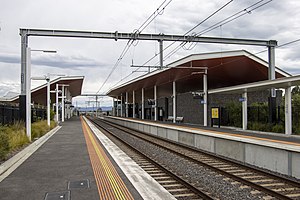
Epping railway station is a commuter railway station on the Mernda line, which is part of the Melbourne railway network, and serves the northern suburb of the same name in Melbourne, Victoria, Australia. It opened on 23 December 1889 and, since 2011, it has been a below-ground, premium station, with an island platform.
Mill Park, Victoria
Suburb of Melbourne, Victoria, Australia
Distance: Approx. 760 meters
Latitude and longitude: -37.671,145.062
Mill Park is a suburb of Melbourne, Victoria, Australia, 18 km north-east of Melbourne's central business district, located within the City of Whittlesea local government area. Mill Park recorded a population of 28,712 at the 2021 census. Mill Park's boundaries are South Morang and Epping to the north, Plenty and the Blossom Park and Rivergum estates to the east, Bundoora and Thomastown to the south and Lalor to the west.

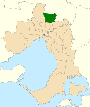
Division of Scullin
Australian federal electoral division
Distance: Approx. 998 meters
Latitude and longitude: -37.663,145.053
The Division of Scullin is an Australian Electoral Division in the state of Victoria. It is located in the outer northern suburbs of Melbourne, including Epping, Lalor, Mill Park, South Morang, Thomastown, Wollert and Bundoora.

South Morang railway station
Railway station in Melbourne, Australia
Distance: Approx. 1721 meters
Latitude and longitude: -37.64916667,145.0675
South Morang railway station is a commuter railway station on the Mernda line, which is part of the Melbourne railway network. It serves the north-eastern suburb of South Morang, in Melbourne, Victoria, Australia. South Morang is a below ground premium station, featuring an island platform with two faces.
Parade College
Private secondary school in Bundoora and Preston, Victoria, Australia
Distance: Approx. 3074 meters
Latitude and longitude: -37.69166667,145.06972222
Parade College is a private Catholic secondary school for boys. It is located across two campuses in the northern suburbs of Melbourne, Victoria, Australia; one at Bundoora; the other, 8 km (5.0 mi) away, at Preston. The school is a member of Edmund Rice Education Australia and the Associated Catholic Colleges.
Westfield Plenty Valley
Shopping mall in Victoria, Australia
Distance: Approx. 1557 meters
Latitude and longitude: -37.6509368,145.0689697
Westfield Plenty Valley is a shopping centre in the suburb of South Morang, Victoria, Australia. Until its expansion in 2008, it was known as Plenty Valley Town Centre and hosted one major store (Coles Supermarket), and approximately 22 specialty stores. Westfield began a re-development program for the centre in 2007, expanding the area to 62,942 square metres (677,500 sq ft), at a cost of approx A$200 million.
Uni Hill Factory Outlets
Shopping mall in Bundoora, Melbourne Australia
Distance: Approx. 2596 meters
Latitude and longitude: -37.685,145.078
Uni Hill Factory Outlets is a shopping precinct located in the University Hill area of Bundoora in the outer north eastern suburbs of Melbourne, Australia. Brand Junction is one of nine precincts anticipated by the Janefield Development Plan, which was approved on 20 July 2004 by the City of Whittlesea and contains a mix of residential, commercial, retail and industry intended to be developed over the next 10–12 years by Melbourne property developer MAB Corporation on a 103.8-hectare (256.5-acre) site which is bounded by Plenty Road to the west, the Metropolitan Ring Road to the south, the Plenty Road Gorge Parklands to the east and RMIT University's Bundoora East Campus to the north. Brand Junction, which was approved by the City of Whittlesea in 2005, has been built by St Hilliers at an expected cost of A$40 million, and is expected to include a Coles supermarket, 28 specialty stores and up to 90 factory outlets in tenancies ranging from 80 square meters to over 500 square meters and offering discounted fashion, footwear, homewares, shopping and lifestyle goods from name brands.
Mill Park Secondary College
Public state-run high school in Victoria, Australia
Distance: Approx. 2071 meters
Latitude and longitude: -37.64583333,145.06277778
Mill Park Secondary College is a government high school located in Epping, Victoria, Australia with its Junior Campus located on Moorhead Drive Mill Park and its Senior Campus located on Civic Drive. The high school was built in the early 1990s for the residents of Mill Park, however due to population growth, a Senior campus was established around 1997 for students entering the years of 10, 11 and 12. In the current day, Mill Park Secondary College has approximately 1,820 students.

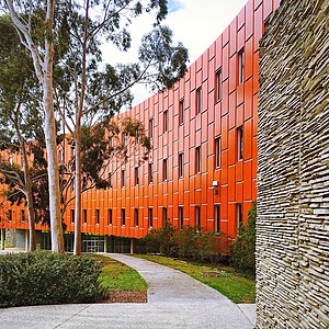
RMIT Building 220
Education in Victoria, Australia
Distance: Approx. 1839 meters
Latitude and longitude: -37.680919,145.064477
The RMIT Building 220 is one of the best known suburban educational buildings in Victoria. Designed by the practice of Wood Marsh, the building was built in 1998 as part of the Royal Melbourne Institute of Technology (RMIT) university Bundoora campus. It is part of RMIT's image campaign where the University is set to become more radical towards a new progressive identity.

Middle Gorge railway station
Railway station in Melbourne, Australia
Distance: Approx. 3312 meters
Latitude and longitude: -37.6443,145.0919
Middle Gorge railway station is a commuter railway station on the Mernda line, part of the Melbourne railway network. It serves the north-eastern Melbourne suburb of South Morang in Victoria, Australia. Middle Gorge is a ground level unstaffed station, featuring two side platforms.

St. Petka Macedonian Orthodox Church, Mill Park
Church in Victoria, Australia
Distance: Approx. 1246 meters
Latitude and longitude: -37.674586,145.070058
St. Petka Macedonian Orthodox Church (Macedonian: Македонска Православна Црква „Св. Петка", Makedonska Pravoslavna Crkva "Sv.

Plenty Gorge Park
Distance: Approx. 2328 meters
Latitude and longitude: -37.6826,145.0772
Plenty Gorge Park is a 1,350-hectare (3,300-acre) metropolitan regional park in the north-eastern Melbourne suburb of Bundoora. The park extends 11km along the Plenty River and encompasses sites including the Hawkstowe and Yarrambat picnic areas, Middle Gorge, Nioka Bush Camp and the Yellow Gum Recreation Area. However, these sites generally operate independently rather than as components of the broader parklands.
Weather in this IP's area
moderate rain
16 Celsius
16 Celsius
15 Celsius
17 Celsius
1011 hPa
88 %
1011 hPa
995 hPa
10000 meters
2.57 m/s
310 degree
75 %
06:01:33
20:06:39