123.51.71.57 - IP Lookup: Free IP Address Lookup, Postal Code Lookup, IP Location Lookup, IP ASN, Public IP
Country:
Region:
City:
Location:
Time Zone:
Postal Code:
IP information under different IP Channel
ip-api
Country
Region
City
ASN
Time Zone
ISP
Blacklist
Proxy
Latitude
Longitude
Postal
Route
Luminati
Country
Region
vic
City
melbourne
ASN
Time Zone
Australia/Melbourne
ISP
Symbio Networks
Latitude
Longitude
Postal
IPinfo
Country
Region
City
ASN
Time Zone
ISP
Blacklist
Proxy
Latitude
Longitude
Postal
Route
IP2Location
123.51.71.57Country
Region
new south wales
City
kempsey
Time Zone
Australia/Sydney
ISP
Language
User-Agent
Latitude
Longitude
Postal
db-ip
Country
Region
City
ASN
Time Zone
ISP
Blacklist
Proxy
Latitude
Longitude
Postal
Route
ipdata
Country
Region
City
ASN
Time Zone
ISP
Blacklist
Proxy
Latitude
Longitude
Postal
Route
Popular places and events near this IP address

Kempsey, New South Wales
Town in New South Wales, Australia
Distance: Approx. 535 meters
Latitude and longitude: -31.08333333,152.83333333
Kempsey is a town in the Mid North Coast region of New South Wales, Australia and is the council seat for Kempsey Shire. It is located roughly 16.5 kilometres inland from the coast of the Pacific Ocean, on the Macleay Valley Way near where the Pacific Highway and the North Coast railway line cross the Macleay River. It is roughly 430 kilometres north of Sydney.

Kempsey Shire
Local government area in New South Wales, Australia
Distance: Approx. 535 meters
Latitude and longitude: -31.08333333,152.83333333
Kempsey Shire is a local government area in the Mid North Coast region of New South Wales, Australia. The shire services an area of 3,380 square kilometres (1,310 sq mi) and is located on the Pacific Highway and the North Coast railway line. Kempsey Shire was formed on 1 October 1975 by the amalgamation of the former Kempsey Municipality and the former Macleay Shire.
St Paul's College, Kempsey
School in Australia
Distance: Approx. 2128 meters
Latitude and longitude: -31.061039,152.823261
St Paul's College is an independent Roman Catholic co-educational secondary day school, located in West Kempsey, New South Wales, Australia. The school caters for students in Year 7 to Year 12.

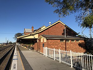
Kempsey railway station
Australian railway station
Distance: Approx. 301 meters
Latitude and longitude: -31.076897,152.832892
Kempsey railway station is located on the North Coast line in New South Wales, Australia. It serves the town of Kempsey, opening on 3 December 1917 when the line was extended from Wauchope. It was the terminus of the line until it was extended to Macksville on 1 July 1919.
Frenchmans Creek (New South Wales)
River in Australia
Distance: Approx. 4739 meters
Latitude and longitude: -31.06666667,152.78333333
Frenchmans Creek is a short tributary of the Darling River in west New South Wales, measuring 7.51 km (5 mi) from its source south of Pooncarie, New South Wales at an elevation of 54.4 m (178 ft) to its confluence into the Darling River at an elevation of 48 metres (157 ft).

St Andrew's Presbyterian Church and Hall, Kempsey
Church in New South Wales, Australia
Distance: Approx. 1137 meters
Latitude and longitude: -31.0784,152.8428
St Andrew's Presbyterian Church and Hall is a heritage-listed former Presbyterian church and church hall, that is now a retail store, located at 67 Smith Street, Kempsey, Kempsey Shire, New South Wales, Australia. It was built from 1890. It was added to the New South Wales State Heritage Register on 2 April 1999.

Kempsey Post Office
Historic site in New South Wales, Australia
Distance: Approx. 1087 meters
Latitude and longitude: -31.0803,152.8422
Kempsey Post Office is a heritage-listed post office at Belgrave Street, Kempsey, Kempsey Shire, New South Wales, Australia. It was designed by the Colonial Architect's Office under James Barnet, and was built by Gabriel and McMorrine, with additions in 1903-04 built by Hocking Brothers. The property is owned by Australia Post.

Macleay River railway bridge, Kempsey
Bridge in New South Wales, Australia
Distance: Approx. 858 meters
Latitude and longitude: -31.0867,152.8314
The Macleay River Railway Bridge is a heritage-listed railway bridge that carries the North Coast railway line across the Macleay River from Kempsey to South Kempsey in New South Wales, Australia.
South Kempsey
Suburb of Kempsey, New South Wales, Australia
Distance: Approx. 4903 meters
Latitude and longitude: -31.12302,152.83253
South Kempsey is a suburb of Kempsey in the Kempsey Shire, New South Wales, Australia. They are separated by the Macleay River. The 2016 census listed 2302 persons within the South Kempsey area.
Macleay Vocational College
Distance: Approx. 1933 meters
Latitude and longitude: -31.0961,152.8274
Macleay Vocational College (MVC), also known as Macleay Valley Workplace Learning Centre Inc., is a secondary school in West Kempsey, New South Wales, Australia. As of 1999, Established in 2001, the Macleay Vocational College (MVC) is part of the Macleay Valley Workplace Learning Centre Inc., a not-for-profit education and training provider. Jann Eason was the developer of the concept and the founding Principal 1999–2012.
West Kempsey
Suburb of Kempsey, New South Wales, Australia
Distance: Approx. 2402 meters
Latitude and longitude: -31.05757,152.82794
West Kempsey is a suburb of Kempsey in the Kempsey Shire, New South Wales, Australia.
East Kempsey
Suburb of Kempsey, New South Wales, Australia
Distance: Approx. 2097 meters
Latitude and longitude: -31.08242,152.85253
East Kempsey is a suburb of Kempsey in the Kempsey Shire, New South Wales, Australia.
Weather in this IP's area
light rain
27 Celsius
27 Celsius
27 Celsius
27 Celsius
1003 hPa
77 %
1003 hPa
1001 hPa
10000 meters
2.68 m/s
2.68 m/s
71 degree
96 %