Country:
Region:
City:
Latitude and Longitude:
Time Zone:
Postal Code:
IP information under different IP Channel
ip-api
Country
Region
City
ASN
Time Zone
ISP
Blacklist
Proxy
Latitude
Longitude
Postal
Route
Luminati
Country
Region
nsw
City
sydney
ASN
Time Zone
Australia/Sydney
ISP
Symbio Networks
Latitude
Longitude
Postal
IPinfo
Country
Region
City
ASN
Time Zone
ISP
Blacklist
Proxy
Latitude
Longitude
Postal
Route
db-ip
Country
Region
City
ASN
Time Zone
ISP
Blacklist
Proxy
Latitude
Longitude
Postal
Route
ipdata
Country
Region
City
ASN
Time Zone
ISP
Blacklist
Proxy
Latitude
Longitude
Postal
Route
Popular places and events near this IP address
Cocoroc, Victoria
Town in Victoria, Australia
Distance: Approx. 5010 meters
Latitude and longitude: -37.967,144.622
Cocoroc is a rural locality in Victoria, Australia, 37 km (23 mi) south-west of Melbourne's Central Business District, located within the City of Wyndham local government area. Cocoroc recorded no population at the 2021 census.

Little River, Victoria
Town in Victoria, Australia
Distance: Approx. 7307 meters
Latitude and longitude: -37.933,144.5
Little River is a town in Victoria, Australia, approximately 44 kilometres (27 mi) south-west of Melbourne's Central Business District, located within the Cities of Greater Geelong and Wyndham local government areas. Little River recorded a population of 1,353 at the 2021 census.

Little River railway station
Railway station in Victoria, Australia
Distance: Approx. 5964 meters
Latitude and longitude: -37.9629,144.4989
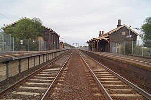
Little River railway station is a regional railway station on the Warrnambool line, part of the Victorian railway network. It serves the town of Little River, in Victoria, Australia. Little River station is a ground level unstaffed station, featuring two side platforms.
Mambourin, Victoria
Town in Victoria, Australia
Distance: Approx. 6998 meters
Latitude and longitude: -37.912,144.549
Mambourin is a newly established urban city in Victoria, Australia, 38 km (24 mi) south-west of Melbourne's Central Business District, located within the City of Wyndham local government area. Mambourin recorded a population of 315 at the 2021 census. The population of Mambourin is experiencing rapid growth, as evidenced by the construction of several thousand new homes annually.

Lake Borrie Wetlands
Distance: Approx. 3487 meters
Latitude and longitude: -38.00416667,144.57361111
Lake Borrie Wetlands is a coastal wetland that is located in the Greater Geelong region of Victoria, Australia. The wetland is situated within the Western Treatment Plant at Werribee; administered by Melbourne Water. Fed by run off from the Little River, the 70-hectare (170-acre) wetland forms part of the Port Phillip Bay (Western Shoreline) and Bellarine Peninsula Ramsar Site as a wetland of international importance.

Western Treatment Plant
Ramsar site and sewage treatment plant in Victoria, Australia
Distance: Approx. 2952 meters
Latitude and longitude: -38,144.56666667
The Western Treatment Plant (formerly the Metropolitan Sewage Farm or, more commonly, the Werribee Sewage Farm) is a 110 km2 (42 sq mi) sewage treatment plant in Cocoroc, Victoria, Australia, 30 km (19 mi) west of Melbourne's central business district, on the coast of Port Phillip Bay. It was completed in 1897 by the Melbourne and Metropolitan Board of Works (MMBW), and is currently operated by Melbourne Water. The plant's land is bordered by the Werribee River to the east, the Princes Freeway to the north, and Avalon Airport to the west.

Manor railway station
Former railway station in Victoria, Australia
Distance: Approx. 4697 meters
Latitude and longitude: -37.93233333,144.57725
Manor is a closed station which was located about halfway between Werribee and Little River stations on the Geelong railway line in Victoria, Australia. A signal box was opened at the site in February 1911, controlling a new crossing loop on the single line between Werribee and Little River. Passenger and goods facilities were provided in August 1914.

Point Wilson, Victoria
Place in Victoria, Australia
Distance: Approx. 6198 meters
Latitude and longitude: -38.02111111,144.52888889
Point Wilson is a locality located on the northern shores of Corio Bay, Victoria. it is approximately 60 kilometres by road from Melbourne, and 25 kilometres by road from Geelong. The locality is bounded by Pousties Road to the west, the Princes Freeway to the north west, Little River to the north east, and Corio Bay to the south.
Werribee Racecourse railway station
Former railway station in Victoria, Australia
Distance: Approx. 9869 meters
Latitude and longitude: -37.90759,144.6407
Werribee Racecourse is a disused station located between Werribee and Little River stations in Werribee, south-west Melbourne, Australia. The station was provided to serve the nearby Werribee Racecourse. When line from Newport to Werribee was electrified in the 1980s, Werribee Racecourse station was originally to be part of the system.
Spit Nature Conservation Reserve
Protected area in Victoria, Australia
Distance: Approx. 9370 meters
Latitude and longitude: -38.04944444,144.51944444
The Spit Nature Conservation Reserve is a 3-kilometer nature reserve on the north-western shore of Port Phillip, a large bay in Victoria, Australia. It consists of public land set aside to conserve and protect species, communities, and habitats of indigenous plants and animals. It is adjacent to the Werribee Sewage Farm and is managed by Parks Victoria.

Werribee and Avalon Important Bird Area
Distance: Approx. 5993 meters
Latitude and longitude: -38.02638889,144.55277778
The Werribee and Avalon Important Bird Area comprises some 37 km2 of coastal land along the northwestern shore of Port Phillip in the state of Victoria, in southeastern Australia. It is important for a wide variety of waterbirds.
Weather in this IP's area
overcast clouds
18 Celsius
17 Celsius
17 Celsius
20 Celsius
1018 hPa
45 %
1018 hPa
1016 hPa
10000 meters
3.6 m/s
300 degree
100 %
06:06:18
20:04:53