123.255.202.59 - IP Lookup: Free IP Address Lookup, Postal Code Lookup, IP Location Lookup, IP ASN, Public IP
Country:
Region:
City:
Location:
Time Zone:
Postal Code:
IP information under different IP Channel
ip-api
Country
Region
City
ASN
Time Zone
ISP
Blacklist
Proxy
Latitude
Longitude
Postal
Route
Luminati
Country
Region
jk
City
jakarta
ASN
Time Zone
Asia/Jakarta
ISP
PT. DATA Utama Dinamika
Latitude
Longitude
Postal
IPinfo
Country
Region
City
ASN
Time Zone
ISP
Blacklist
Proxy
Latitude
Longitude
Postal
Route
IP2Location
123.255.202.59Country
Region
jawa timur
City
pacarkeling
Time Zone
Asia/Jakarta
ISP
Language
User-Agent
Latitude
Longitude
Postal
db-ip
Country
Region
City
ASN
Time Zone
ISP
Blacklist
Proxy
Latitude
Longitude
Postal
Route
ipdata
Country
Region
City
ASN
Time Zone
ISP
Blacklist
Proxy
Latitude
Longitude
Postal
Route
Popular places and events near this IP address

Gelora 10 November Stadium
Football stadium in Indonesia
Distance: Approx. 753 meters
Latitude and longitude: -7.25157,112.755989
Gelora 10 November Stadium (Indonesian: Stadion Gelora 10 November; literally "10 November Sports Arena Stadium"), formerly known as Tambaksari Stadium, is a football stadium located in Tambaksari, Surabaya, East Java, Indonesia. It is currently used mostly for association football matches. Originally a football field named Tambaksari Field (Indonesian: Lapangan Tambaksari), the stadium holds 20,000 people.

Airlangga University
Indonesian university
Distance: Approx. 1521 meters
Latitude and longitude: -7.27166667,112.75805556
Airlangga University (Indonesian: Universitas Airlangga; Javanese: ꦈꦤꦶꦮ꦳ꦼꦂꦱꦶꦠꦱ꧀ꦄꦲꦶꦂꦭꦁꦒ, abbreviated as UNAIR) is the second-oldest university in Indonesia and also a public university located in Surabaya, East Java. Despite being officially established by Indonesian Government Regulation in 1954, Universitas Airlangga was first founded in 1948 as a distant branch of the University of Indonesia, with roots dating back to 1913. It started with a medical school and a school of dentistry.

Battle of Surabaya
Battle between British and Indonesian forces
Distance: Approx. 2038 meters
Latitude and longitude: -7.25972222,112.73972222
The Battle of Surabaya (Indonesian: Pertempuran Surabaya) was a major battle in the Indonesian National Revolution fought between regular infantry and militia of the Indonesian nationalist movement and British and British Indian troops against the re-imposition of Dutch colonial rule. The peak of the battle was in November 1945. The battle was the largest single battle of the revolution and became a national symbol of Indonesian resistance.

Hotel Majapahit
Hotel in East Java, Indonesia
Distance: Approx. 2038 meters
Latitude and longitude: -7.25972222,112.73972222
The Hotel Majapahit is a historic hotel in Surabaya, East Java, Indonesia, opened in 1911. The hotel is currently managed by Accor through its MGallery chain.
BII Tower
Skyscraper in Surabaya, Indonesia
Distance: Approx. 1458 meters
Latitude and longitude: -7.265,112.74694444
BII Tower is a skyscraper building in Surabaya. It is situated in the city center and has a height of 200 meters. It is one of the highest tower in Surabaya.

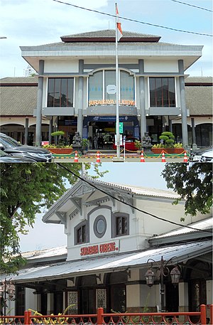
Surabaya Gubeng railway station
Railway station in Indonesia
Distance: Approx. 1038 meters
Latitude and longitude: -7.26527778,112.75222222
Surabaya Gubeng Station, known as Spoorwegstation Goebeng Soerabaja during the Dutch East Indies era, is a railway station located at Gubeng Station Street, Pacarkeling, Tambaksari, Surabaya, East Java, Indonesia. This station is the biggest railway station in Surabaya and East Java, and is a departure from the main railway in Surabaya, especially towards the south and east, while the train that passes through the northern route, such as majors train Jakarta via Semarang, departed from Surabaya Pasar Turi Station. Surabaya Gubeng station was first built on the west side of the railway tracks.
Gubeng, Gubeng, Surabaya
Village in East Java, Indonesia
Distance: Approx. 1922 meters
Latitude and longitude: -7.2729,112.7493
Gubeng is the name of an urban village (kelurahan), which in turn is a part of a district (kecamatan) with the same name in the city of Surabaya, East Java, Indonesia.

Surabaya City Hall
City Hall in Surabaya, Indonesia
Distance: Approx. 1233 meters
Latitude and longitude: -7.259257,112.747003
Surabaya City Hall (Indonesian: Balai Kota Surabaya) is the administrative center of the city of Surabaya. The building was built by Cosman Citroen in the 1920s. The building is one of the example of 20th century buildings designed in a tropical-conscious climate of Indonesia, the style is known as the New Indies Style.

KRI Pasopati
Indonesian Navy submarine, retired 1994
Distance: Approx. 1203 meters
Latitude and longitude: -7.26552,112.75028
KRI Pasopati (410) (ex-Soviet submarine S-290) is a retired Project 613 Whiskey-class submarine of the Indonesian Navy.

Consulate-General of Japan, Surabaya
Consular representation of Japan in Indonesia
Distance: Approx. 2061 meters
Latitude and longitude: -7.272533,112.746539
The Consulate-General of Japan, Surabaya (Japanese: 在スラバヤ日本国総領事館, romanized: Zai Surabaya Nipponkoku sōryōjikan; Indonesian: Konsulat Jenderal Jepang, Surabaya) is a Japanese diplomatic mission to Indonesia in Surabaya, East Java. The first Japanese diplomatic mission in Surabaya was established on 13 March 1920 while the city was under rule of the Dutch East Indies. In 1979, the consulate upgraded its status to Consulate-General.

Surabaya Synagogue
Former synagogue in Surabaya, Indonesia
Distance: Approx. 1371 meters
Latitude and longitude: -7.266626,112.749239
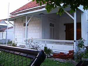
The Surabaya Synagogue, officially the Beth Shalom Synagogue, was a former Jewish congregation and synagogue, located in Surabaya, Java, Indonesia. It is generally said to have been the only synagogue in the country during the years it operated, although since then Sha'ar Hashamayim has opened in Sulawesi. The Surabaya Synagogue building was a former private residence purchased by the Israelitische Gemeente Soerabaia congregation in 1948.

Balai Pemuda
Building in Surabaya
Distance: Approx. 1560 meters
Latitude and longitude: -7.2639219,112.74529301
Balai Pemuda or Alun-Alun Surabaya is a rich historical site in Surabaya. The site serves as a hub for cultural and artistic activities.
Weather in this IP's area
few clouds
27 Celsius
30 Celsius
26 Celsius
27 Celsius
1010 hPa
89 %
1010 hPa
1009 hPa
7000 meters
3.09 m/s
270 degree
20 %