123.200.200.6 - IP Lookup: Free IP Address Lookup, Postal Code Lookup, IP Location Lookup, IP ASN, Public IP
Country:
Region:
City:
Location:
Time Zone:
Postal Code:
IP information under different IP Channel
ip-api
Country
Region
City
ASN
Time Zone
ISP
Blacklist
Proxy
Latitude
Longitude
Postal
Route
Luminati
Country
ASN
Time Zone
Australia/Sydney
ISP
iseek Communications Pty Ltd
Latitude
Longitude
Postal
IPinfo
Country
Region
City
ASN
Time Zone
ISP
Blacklist
Proxy
Latitude
Longitude
Postal
Route
IP2Location
123.200.200.6Country
Region
victoria
City
port melbourne
Time Zone
Australia/Melbourne
ISP
Language
User-Agent
Latitude
Longitude
Postal
db-ip
Country
Region
City
ASN
Time Zone
ISP
Blacklist
Proxy
Latitude
Longitude
Postal
Route
ipdata
Country
Region
City
ASN
Time Zone
ISP
Blacklist
Proxy
Latitude
Longitude
Postal
Route
Popular places and events near this IP address

Albert Park, Victoria
Suburb of Melbourne, Victoria, Australia
Distance: Approx. 728 meters
Latitude and longitude: -37.842,144.95
Albert Park is an inner suburb of Melbourne, Victoria, Australia, 4 km (2.5 mi) south of Melbourne's Central Business District. The suburb is named after Albert Park, a large lakeside urban park located within the City of Port Phillip local government area. Albert Park recorded a population of 6,044 at the 2021 census.

Station Pier
Historic Australian pier on Port Phillip, in Port Melbourne, Victoria
Distance: Approx. 1120 meters
Latitude and longitude: -37.8444,144.9311
Station Pier is a historic Australian pier on Port Phillip, in Port Melbourne, Victoria. Opened in 1854, the pier is Melbourne's primary passenger terminal, servicing interstate ferries and cruise ships, and is listed on the Victorian Heritage Register.

St Vincent Gardens
Distance: Approx. 1163 meters
Latitude and longitude: -37.8389,144.9555
St Vincent Gardens in the Melbourne suburb of Albert Park, is an Australian park of national significance. It is an example of nineteenth century residential development around a large landscaped square. Development occurred as a result of a boom following the Victorian gold rush.

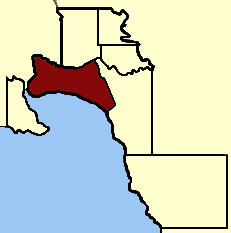
Electoral district of Albert Park
State electoral district of Victoria, Australia
Distance: Approx. 972 meters
Latitude and longitude: -37.83333333,144.95
The electoral district of Albert Park is one of the electoral districts of Victoria, Australia, for the Victorian Legislative Assembly. It covers an area of 21 square kilometres (8.1 sq mi) in inner suburban Melbourne, and includes the suburbs of Albert Park, Middle Park, Port Melbourne, St Kilda West, Southbank, South Melbourne, South Wharf, and parts of St Kilda. It lies within the Southern Metropolitan Region of the upper house, the Legislative Council.

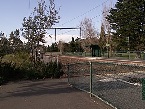
Graham Street light rail station
Light rail station in Melbourne, Victoria
Distance: Approx. 515 meters
Latitude and longitude: -37.83694444,144.9375
Graham Street is light rail station and former railway station on the former Port Melbourne railway line, in the inner Melbourne suburb of Port Melbourne, Victoria, Australia. Located to the north of Graham Street, between Evans Street and Station Street, the station has been demolished since 1987, and is now served by route 109 trams, stopping at a pair of low level platforms.

Beacon Cove light rail station
Light rail station in Melbourne, Victoria
Distance: Approx. 827 meters
Latitude and longitude: -37.8407,144.933
Beacon Cove is a light rail station in the Melbourne suburb of Port Melbourne located on the former Port Melbourne line, the first significant railway in Australia. The station used to be called Port Melbourne, and was opened in 1854 to carry passengers arriving at Station Pier to Flinders Street station. The railway line was closed in 1987 to be converted to light rail, currently route 109.

North Port Oval
Sports stadium in Melbourne, Australia
Distance: Approx. 976 meters
Latitude and longitude: -37.83083333,144.94222222
North Port Oval, also known as the Port Melbourne Cricket Ground or by the sponsored name ETU Stadium, is an Australian rules football and cricket stadium located in Port Melbourne, Australia. The capacity of the venue is 6,000 people. It is home to both the Port Melbourne Cricket Club and the Port Melbourne Football Club.

St Vincent Place
Distance: Approx. 1118 meters
Latitude and longitude: -37.83916667,144.955
St Vincent Place is a heritage precinct in Albert Park, Victoria, Australia. St Vincent Place is bounded by Park Street, Cecil Street, Bridport Street, Cardigan Place and Nelson Road. It is bisected by Montague Street, allowing the passage of trams on route 1.
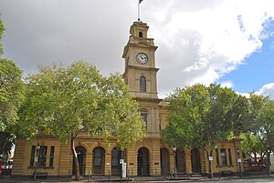
Port Melbourne Town Hall
Town hall in Melbourne, Australia
Distance: Approx. 472 meters
Latitude and longitude: -37.835708,144.944429
The Port Melbourne Town Hall was erected in 1882. The Town Hall is an important element in the historic Bay Street streetscape of inner city Port Melbourne. After the amalgamation of the City of Port Melbourne with the City of South Melbourne and the City of St Kilda in 1994 to form the City of Port Phillip, the Town Hall now functions as secondary offices for the Port Phillip City Council of the new City of Port Phillip.

Electoral district of South Melbourne
Australian electorate
Distance: Approx. 972 meters
Latitude and longitude: -37.83333333,144.95
Electoral district of South Melbourne was an electoral district of the Legislative Assembly in the British colony of Victoria (Australia). Its area was defined by the Victoria Constitution Act as: "Bounded on the North by the Yarra Yarra River, from its Junction with the Saltwater River to Princes’ Bridge, on the East by the Road bearing Southeast to the Northern Angle of Section No. 46, St.

Albert Park College
Public school in Albert Park, Victoria, Australia
Distance: Approx. 739 meters
Latitude and longitude: -37.84472,144.94765
Albert Park College is a public, co-educational high school located in Albert Park, Victoria, Australia. In 2018, the school had 1036 enrolments and 79 teaching staff. Construction of the new school was completed in late 2010 and it opened in February 2011.

North Port light rail station
Light rail station in Melbourne, Victoria
Distance: Approx. 703 meters
Latitude and longitude: -37.83333333,144.94333333
North Port is a light rail station and a former railway station on Port Melbourne railway line, first significant railway in Melbourne, Australia. The station is located in the inner Melbourne suburb of Port Melbourne, Victoria, Australia. Though it was closed in 1987 for conversion to light rail, Melbourne tram route 109 now runs through the station with newly built low-floor platforms.
Weather in this IP's area
clear sky
13 Celsius
12 Celsius
11 Celsius
15 Celsius
1022 hPa
79 %
1022 hPa
1021 hPa
10000 meters
4.7 m/s
7.78 m/s
174 degree
6 %
