Country:
Region:
City:
Latitude and Longitude:
Time Zone:
Postal Code:
IP information under different IP Channel
ip-api
Country
Region
City
ASN
Time Zone
ISP
Blacklist
Proxy
Latitude
Longitude
Postal
Route
Luminati
Country
ASN
Time Zone
Asia/Singapore
ISP
A-STAR
Latitude
Longitude
Postal
IPinfo
Country
Region
City
ASN
Time Zone
ISP
Blacklist
Proxy
Latitude
Longitude
Postal
Route
db-ip
Country
Region
City
ASN
Time Zone
ISP
Blacklist
Proxy
Latitude
Longitude
Postal
Route
ipdata
Country
Region
City
ASN
Time Zone
ISP
Blacklist
Proxy
Latitude
Longitude
Postal
Route
Popular places and events near this IP address

Jurong East MRT station
Mass Rapid Transit station in Singapore
Distance: Approx. 682 meters
Latitude and longitude: 1.333415,103.742119
Jurong East MRT station is an elevated Mass Rapid Transit (MRT) interchange station on the North–South (NSL) and East–West (EWL) lines in Jurong East, Singapore. Situated along Jurong Gateway Road, the station is located within the vicinity of Jem, Westgate, IMM, Ng Teng Fong General Hospital, Jurong East Bus Interchange and Jurong Town Hall Bus Interchange. The station is operated by SMRT Trains.

Jurong East
Planning Area and Regional Centre in West Region, Singapore
Distance: Approx. 649 meters
Latitude and longitude: 1.32888333,103.73994722
Jurong East is a planning area and residential town situated in the West Region of Singapore. It borders Jurong West and Boon Lay to the west, Clementi to the east, Tengah and Bukit Batok to the north and Selat Jurong to the south. First developed in the 1970s, it is located approximately 15 km (9.3 miles) west of the Downtown Core district.

Jurong East Bus Interchange
Distance: Approx. 692 meters
Latitude and longitude: 1.335,103.74194444
Jurong East Bus Interchange is a bus interchange located in Jurong East, Singapore. An open-air single-level bus terminal, it is connected to the adjacent Jurong East MRT station via a link bridge.
Jurong Regional Library
Regional library in Singapore
Distance: Approx. 401 meters
Latitude and longitude: 1.33269167,103.739575
Jurong Regional Library (Chinese: 裕廊区域图书馆; Malay: Perpustakaan Wilayah Jurong) is a public library located in Jurong East, Singapore. It is located next to JCube and is within walking distances of Jurong East Bus Interchange and Jurong East MRT station. It is the third regional library to be completed after the Tampines and Woodlands regional libraries and is currently the largest public library under the National Library Board network of public libraries.
Jurong Entertainment Centre
Defunct Singapore shopping mall
Distance: Approx. 443 meters
Latitude and longitude: 1.33331944,103.739975
Jurong Entertainment Centre was an entertainment centre once located at Jurong East, Singapore.
Snow City
Singapore's first indoor snow centre located within the Science Centre Singapore
Distance: Approx. 240 meters
Latitude and longitude: 1.33516667,103.73519444
Snow City is Singapore's first indoor snow center located within the Science Centre Singapore area, beside the Omni-Theatre in Jurong East.
Omni-Theatre, Science Centre Singapore
Distance: Approx. 175 meters
Latitude and longitude: 1.33455556,103.73525
The Omni-Theatre is an observatory and large-format film theatre located at the Science Centre Singapore (formerly Singapore Science Centre) in Jurong East, Singapore.

Japanese Garden, Singapore
Park in Jurong East, Singapore
Distance: Approx. 660 meters
Latitude and longitude: 1.33596111,103.73076944
Japanese Garden (Japanese: 日本庭園) is a park and garden located in Jurong East, Singapore. Built in 1974 by JTC Corporation, it covers 13.5 hectares (135,000 m2) of land. It is built on an artificial island in Jurong Lake and is connected to the adjacent Chinese Garden island by bridge named the Bridge of Double Beauty.

JCube
Former shopping mall in Singapore
Distance: Approx. 443 meters
Latitude and longitude: 1.33331944,103.739975
JCube was a shopping centre located in Jurong East, Singapore, that operated from 2 April 2012 to 6 August 2023. It used to house an Olympic-size ice rink and Singapore's first IMAX theatre in the suburbs. It was built on the former site of the Jurong Entertainment Centre.

Jurong Town Hall Road
Road in Jurong East, Singapore
Distance: Approx. 613 meters
Latitude and longitude: 1.33108056,103.7411
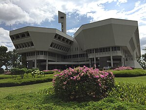
Jurong Town Hall Road (Chinese: 裕廊镇大会堂路) is a road in Jurong East, Singapore that connects the Pan Island Expressway and West Coast Road. It was built in 1969 through Jalan Bahru Selatan so that Route 143 could connect to the Jurong Road 10-milestone market. It was named after the Jurong Town Hall, built between May 1971 and March 1974 as the headquarters for the Jurong Town Corporation (now JTC Corporation) which had been formed in June 1968 to develop and manage industrial estates in Jurong.
Singapore National Academy of Science
Distance: Approx. 279 meters
Latitude and longitude: 1.3333,103.7335
Singapore National Academy of Science (SNAS) is a government funded body in Singapore founded in 1967 and re-purposed in 1976 when some functions were invested into the Singapore Association for the Advancement of Science (SAAS). Since 2011, SNAS has begun to elect her own fellows.

Jurong Lake District MRT station
Future Mass Rapid Transit station in Singapore
Distance: Approx. 743 meters
Latitude and longitude: 1.327245,103.73908
Jurong Lake District MRT station is a future underground Mass Rapid Transit (MRT) station on the Cross Island line (CRL) located in Jurong East, Singapore. First announced in September 2022, the station is expected to be completed in 2032 along with the other CRL Phase 2 stations.
Weather in this IP's area
moderate rain
32 Celsius
35 Celsius
31 Celsius
32 Celsius
1008 hPa
53 %
1008 hPa
1007 hPa
10000 meters
1.54 m/s
360 degree
75 %
06:48:16
18:51:39


