Country:
 India
IndiaRegion:
City:
Latitude and Longitude:
Time Zone:
Postal Code:
IP information under different IP Channel
ip-api
Country
Region
City
ASN
Time Zone
ISP
Blacklist
Proxy
Latitude
Longitude
Postal
Route
IPinfo
Country
Region
City
ASN
Time Zone
ISP
Blacklist
Proxy
Latitude
Longitude
Postal
Route
MaxMind
Country
Region
City
ASN
Time Zone
ISP
Blacklist
Proxy
Latitude
Longitude
Postal
Route
Luminati
Country
INASN
Time Zone
Asia/Kolkata
ISP
NTT COMMUNICATIONS INDIA NETWORK SERVICES PRIVATE LIMITED
Latitude
Longitude
Postal
db-ip
Country
Region
City
ASN
Time Zone
ISP
Blacklist
Proxy
Latitude
Longitude
Postal
Route
ipdata
Country
Region
City
ASN
Time Zone
ISP
Blacklist
Proxy
Latitude
Longitude
Postal
Route
Popular places and events near this IP address
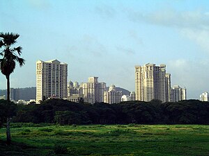
Powai
Suburb in Mumbai Suburban, Maharashtra, India
Distance: Approx. 2140 meters
Latitude and longitude: 19.12,72.91
Powai (Pronunciation: [pəʋəiː]) is a residential suburb located in central Mumbai, Maharashtra, India. It is situated on the banks of Powai Lake, and is bound by the hills of Vikhroli Parksite to the south-east, Chandivali to the south-west, the L.B.S. Marg (old Mumbai-Agra road) to the north-east and the Sanjay Gandhi National Park to the north beyond the lake. The Jogeshwari-Vikhroli Link Road, one of the city's busiest thoroughfares linking the western and eastern suburbs, passes through Powai.
Vikhroli
Suburb in Mumbai Suburban, Maharashtra, India
Distance: Approx. 1451 meters
Latitude and longitude: 19.11,72.94
Vikhroli (Marathi pronunciation: [ʋikʰɾoɭiː]) is a suburb of Mumbai located on the northeastern side of the city. The suburb has a railway station by the name Vikhroli on the Central Railway line. It is also home to one of the largest mangrove forests in Maharashtra, India.
Mumbai North East Lok Sabha constituency
Lok Sabha constituency in Maharashtra
Distance: Approx. 2425 meters
Latitude and longitude: 19.13,72.93
Mumbai North East Lok Sabha constituency is a Lok Sabha parliamentary constituency of Maharashtra.
Amrut Nagar
Neighbourhood in Mumbai Suburban, Maharashtra, India
Distance: Approx. 1587 meters
Latitude and longitude: 19.102077,72.912835
Amrut Nagar is a neighbourhood in Ghatkopar, a suburb of Mumbai in India. Amrut Nagar borders Ghatkopar (West), and is adjacent to Parksite, Vikhroli. It has the pincode 400086.
Kendriya Vidyalaya, IIT Powai
Distance: Approx. 2436 meters
Latitude and longitude: 19.1291,72.9185
Kendriya Vidyalaya, IIT Powai (also known as Kendriya Vidyalaya, IIT Bombay and KV Powai), is an Indian Institute of Technology (IIT) secondary school affiliated to Central Board of Secondary Education (CBSE) board in Mumbai, India. It was established on 15 December 1964. It is part of the Kendriya Vidyalaya Sangathan.
July 2003 Mumbai bombing
Distance: Approx. 1953 meters
Latitude and longitude: 19.095213,72.914178
At 21:15 on 28 July 2003 a bomb placed under a seat of a B.E.S.T. bus exploded on the busy Lal Bahadur Shastri Marg in Ghatkopar. The bomb was placed in the rear of the bus, killing four people and injuring 32. A man who was riding a motorcycle behind the bus and a woman who was in a rickshaw travelling near the bus were among those killed.

Vikhroli Assembly constituency
Constituency of the Maharashtra legislative assembly in India
Distance: Approx. 423 meters
Latitude and longitude: 19.11,72.93
Vikhroli Assembly constituency is one of the 288 Vidhan Sabha (Legislative Assembly) constituencies of Maharashtra state in western India.
Centre for Excellence in Telecom Technology and Management
Distance: Approx. 1634 meters
Latitude and longitude: 19.118936,72.91538
Centre for Excellence in Telecom Technology and Management (CETTM) located in Hiranandani Gardens, Powai, Mumbai is the telecom training centre of MTNL, the incumbent operator of Government of India (GOI). It was founded in 2003 as one of the largest telecom training centres in India and amongst the biggest in Asia. The Centre provides extensive training to corporate employees, students, and MTNL's internal employees in telecom switching, transmission, wireless communication, telecom operations and management .

Udayachal High School
Private school in Mumbai, Maharashtra, India
Distance: Approx. 753 meters
Latitude and longitude: 19.10194444,72.92805556
Udayachal High School is an English-medium school situated in Vikhroli East, Mumbai, India. Udayachal means "eastern mountains". It is affiliated with the International School Award that is awarded to elite schools by the British Council.
Maharashtra National Law University, Mumbai
National Law University located at Mumbai, Maharashtra, India
Distance: Approx. 1657 meters
Latitude and longitude: 19.119103,72.915244
Maharashtra National Law University, Mumbai (MNLU, Mumbai or NLU, Mumbai ) is a National Law University located at Mumbai, Maharashtra, India. MNLU Mumbai, was the countries 18th and Maharashtra's 1st NLU but even after being a new NLU in comparison to the other top NLUs and law colleges of India which were established years or even decades ago, NLU Mumbai, has shown a tremendous growth in terms of placements, college ranking and various other academic and non-academic areas and today it has surpassed many colleges in almost every field and is ranked one among the TOP 10 Law colleges of India. One of the main reason for the excellent growth of NLU/MNLU Mumbai, and its market value can be attributed to its locational advantage which attracts many great placements and PPOs towards itself as Mumbai has the headquarters and offices of various law firms, corporate houses, MNCs and other companies.

Hiranandani Gardens, Mumbai
Township in Maharashtra, India
Distance: Approx. 1923 meters
Latitude and longitude: 19.118986,72.911767
Hiranandani Gardens (known popularly as Hiranandani) is an upmarket township consisting of condominiums, penthouses, bungalows and commercial complexes in Powai in the city of Mumbai. Hiranandani was constructed by the Hiranandani Group and can be accessed by JVLR from the North and LBS Marg from the South. Hiranandani consists of residential buildings, office buildings, hospital, schools, gardens, community centre, sports club, banks, shopping malls, film studio, bus garage, hotels, restaurants, pubs and swimming pools.
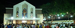
Holy Trinity Church, Powai
Church in Mumbai, India
Distance: Approx. 2407 meters
Latitude and longitude: 19.12963889,72.92147222
Holy Trinity Church or the Most Holy Trinity is a Roman Catholic church in Powai, a suburb of Mumbai. It was built during the Portuguese era by the Jesuits in 1557 and belongs to the Archdiocese of Bombay.
Weather in this IP's area
thunderstorm with rain
24 Celsius
25 Celsius
24 Celsius
24 Celsius
1011 hPa
88 %
1011 hPa
1009 hPa
1500 meters
2.57 m/s
360 degree
75 %
06:33:35
18:12:33