Country:
Region:
City:
Latitude and Longitude:
Time Zone:
Postal Code:
IP information under different IP Channel
ip-api
Country
Region
City
ASN
Time Zone
ISP
Blacklist
Proxy
Latitude
Longitude
Postal
Route
Luminati
Country
Region
wgn
City
wellington
ASN
Time Zone
Pacific/Auckland
ISP
Spark New Zealand Trading Ltd.
Latitude
Longitude
Postal
IPinfo
Country
Region
City
ASN
Time Zone
ISP
Blacklist
Proxy
Latitude
Longitude
Postal
Route
db-ip
Country
Region
City
ASN
Time Zone
ISP
Blacklist
Proxy
Latitude
Longitude
Postal
Route
ipdata
Country
Region
City
ASN
Time Zone
ISP
Blacklist
Proxy
Latitude
Longitude
Postal
Route
Popular places and events near this IP address

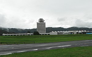
GNS Science
New Zealand research institute
Distance: Approx. 2072 meters
Latitude and longitude: -41.195565,174.933175
GNS Science (Māori: Te Pū Ao), officially registered as the Institute of Geological and Nuclear Sciences Limited, is a New Zealand Crown Research Institute. It focuses on geology, geophysics (including seismology and volcanology), and nuclear science (particularly ion-beam technologies, isotope science and carbon dating).

Naenae
Suburb of Lower Hutt, New Zealand
Distance: Approx. 743 meters
Latitude and longitude: -41.2002,174.9525
Naenae (, occasionally spelled NaeNae) is a suburb of Lower Hutt, New Zealand. It lies on the eastern edge of the floodplain of the Hutt River, four kilometres from the Lower Hutt Central business district. A small tributary of the Hutt, the Waiwhetū Stream, flows through the suburb.
Avalon, New Zealand
Suburb of Lower Hutt, New Zealand
Distance: Approx. 1480 meters
Latitude and longitude: -41.1931,174.9404
Avalon is a suburb of Lower Hutt, in the Wellington Region of New Zealand. It was formed as a private residential development in the 1970s on land formerly occupied by market-gardens on the left (eastern) bank of the Hutt River. It features mostly California-inspired designed houses, often split-level, with 3 or 4 bedrooms.
Taitā, New Zealand
Suburb of Lower Hutt, New Zealand
Distance: Approx. 1668 meters
Latitude and longitude: -41.18,174.96
Taitā () is one of the northernmost suburbs of the city of Lower Hutt in New Zealand, situated toward the northern end of the city. It lies considerably south of the Taitā Gorge which separates Lower Hutt City from Upper Hutt City, and to the west of the Taitā Cemetery in the suburb of Naenae. The historic Christ Church, erected in 1853, is the oldest surviving church building in the Wellington region.
Wingate, New Zealand
Suburb of Lower Hutt, New Zealand
Distance: Approx. 871 meters
Latitude and longitude: -41.188,174.953
Wingate is a mixed residential and industrial neighbourhood of Lower Hutt, in the Wellington Region of New Zealand's North Island. Served by Wingate Railway Station, the area comprises parts of the suburbs of Taitā, Avalon and Naenae. The area is home to many of Lower Hutt's manufacturing and export-oriented businesses.
Kimi Ora School
School
Distance: Approx. 1288 meters
Latitude and longitude: -41.1973361,174.9428642
Kimi Ora School Wellington is a special needs school in Wellington, New Zealand, for students with disabilities. Kimi ora is Maori for "seeking well-being in health" or "to be made whole". Kimi Ora Specialist School caters for High and Very high special needs pupils of primary and secondary school age to adulthood, or ages 5 to 21, and draws pupils from the Wellington region, up to the Kapiti Coast and the Hutt Valley.

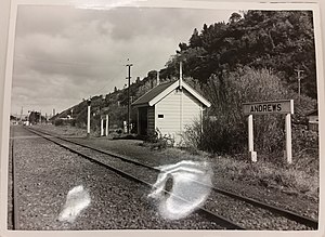
Andrews railway station
Defunct railway station in New Zealand
Distance: Approx. 1908 meters
Latitude and longitude: -41.18306944,174.941425
Andrews Railway Station was a station on the Hutt Valley Line section of the Wairarapa Line in New Zealand. The line ran up the western side of the valley until 28 February 1954 when the Melling-Belmont section of the line closed. Andrews was north of Melling and the Belmont stations, but south of Gosse & Co’s siding, on the closed section of line.
Pitcaithly's railway station
Defunct railway station in New Zealand
Distance: Approx. 1926 meters
Latitude and longitude: -41.1809,174.9444
Pitcaithly’s railway station and siding was a station on the Hutt Valley Line section of the Wairarapa Line in New Zealand north of Melling, which ran up the western side of the valley until 1954. It was replaced by Andrews railway station in 1938.
Christ Church, Taita
Church in New Zealand
Distance: Approx. 1438 meters
Latitude and longitude: -41.18212,174.96042
Christ Church is a heritage-listed Anglican church located in Taitā, Lower Hutt in the Wellington region of New Zealand. The church is the oldest surviving church in the Wellington region.
Naenae College
School
Distance: Approx. 1398 meters
Latitude and longitude: -41.1968,174.9414
Naenae College, is a state-run coeducational secondary school located in north-central Lower Hutt, New Zealand. It is situated on a 12-hectare (30-acre) site in the suburb of Avalon. The school was founded in 1953 to serve the Naenae state housing development, although the school is located in the suburb of Avalon.
Television New Zealand Archive
Archive
Distance: Approx. 1352 meters
Latitude and longitude: -41.1874,174.9452
The Television New Zealand Archive collection contains over 600,000 hours of television spanning almost 55 years of New Zealand's public television history. It includes New Zealand content such as documentaries, dramas, sports programmes and every TVNZ news broadcast from December 1986 to 2014. The archive only holds titles that have previously been broadcast – raw footage is not included.
Fraser Park
Distance: Approx. 1360 meters
Latitude and longitude: -41.18466667,174.94904167
Fraser Park is Lower Hutt's largest recreational sportsground, at 27 hectares it is the biggest sporting ground in the lower North Island. It is home to the Ricoh Sports Centre, a multi-use venue, as well as sports like rugby, rugby league, football, touch football, cricket, kilikiti (Samoan cricket) and softball.
Weather in this IP's area
light rain
18 Celsius
18 Celsius
18 Celsius
19 Celsius
1016 hPa
78 %
1016 hPa
1011 hPa
10000 meters
11.83 m/s
18.52 m/s
350 degree
75 %
05:57:46
20:10:16

