Country:
Region:
City:
Latitude and Longitude:
Time Zone:
Postal Code:
IP information under different IP Channel
ip-api
Country
Region
City
ASN
Time Zone
ISP
Blacklist
Proxy
Latitude
Longitude
Postal
Route
Luminati
Country
ASN
Time Zone
Asia/Jakarta
ISP
PT PC24 Telekomunikasi Indonesia
Latitude
Longitude
Postal
IPinfo
Country
Region
City
ASN
Time Zone
ISP
Blacklist
Proxy
Latitude
Longitude
Postal
Route
db-ip
Country
Region
City
ASN
Time Zone
ISP
Blacklist
Proxy
Latitude
Longitude
Postal
Route
ipdata
Country
Region
City
ASN
Time Zone
ISP
Blacklist
Proxy
Latitude
Longitude
Postal
Route
Popular places and events near this IP address

Blok M, Jakarta
Shopping and entertainment quarter in Jakarta, Indonesia
Distance: Approx. 507 meters
Latitude and longitude: -6.244554,106.800676
Blok M is a business and shopping quarter located in Kebayoran Baru, South Jakarta, Indonesia. It runs east from Iskandarsyah street to Bulungan street in the west. North from Falatehan street to Melawai street in the south.

Perusahaan Listrik Negara
Indonesian state-owned electricity distribution company
Distance: Approx. 639 meters
Latitude and longitude: -6.24055556,106.80336111
PT Perusahaan Listrik Negara (Persero) (lit. 'State Electricity Company', abbreviated as PLN) is an Indonesian government-owned corporation which has a monopoly on electric power distribution in Indonesia and generates the majority of the country's electrical power, producing 176.4 TWh in 2015. It was included in the Fortune Global 500 lists of 2014 and 2015. It has large debts due to expensive coal power contracts.
PTIK Stadium
Football stadium in Indonesia
Distance: Approx. 235 meters
Latitude and longitude: -6.244878,106.806761
PTIK Stadium is a football stadium in the City of South Jakarta, Indonesia. The stadium has a capacity of 3,000 people. The stadium is owned by the Indonesian National Police.

Al-Azhar Great Mosque
Mosque in Kebayoran Baru, Jakarta, Indonesia
Distance: Approx. 1366 meters
Latitude and longitude: -6.2351614,106.7993264
Al-Azhar Great Mosque (Indonesian: Masjid Agung Al-Azhar) is a mosque located in Jalan Sisingamangaraja, Kebayoran Baru, Jakarta. The mosque was constructed between 1953 and 1958. It was originally known simply as Mesjid Agung (Great Mosque).
Peruri 88
Skyscraper in Jakarta, Indonesia
Distance: Approx. 624 meters
Latitude and longitude: -6.242573,106.800585
Peruri 88 is an under construction skyscraper at Kebayoran Baru, Jakarta, Indonesia. The skyscraper will be 389 meters (1,276 ft) high at the tip and will have 88 floors above, 6 floors below the ground. It is a mixed use development, with a hotel, offices, and residential apartments.

Kemang Village
Shopping mall in Jakarta, Indonesia
Distance: Approx. 1651 meters
Latitude and longitude: -6.259418,106.811473
Kemang Village is an integrated development of vertical residences with a shopping mall named Lippo Mall Kemang, hotel, hospital, school, country club, and spa, located at Mampang Prapatan, South Jakarta, Indonesia. The complex has a land area of about 15.5 hectares (38 acres), which is developed by Lippo Group.

ASEAN MRT station
MRT station in Jakarta, Indonesia
Distance: Approx. 1051 meters
Latitude and longitude: -6.239085,106.7985954
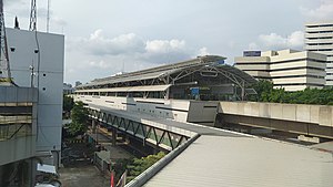
ASEAN Station (formerly Sisingamangaraja Station) is a rapid transit station on the North-South Line of the Jakarta MRT in Jakarta, Indonesia. The station is located in the Gunung area, Kebayoran Baru, South Jakarta and is built on Jalan Sisingamangaraja XII. This station is the northernmost elevated station for the first phase of the Jakarta MRT project before entering the underground line. It is located between Senayan and Blok M BCA stations, and has the station code SSM. It is connected to the TransJakarta at the .

Blok M BCA MRT station
MRT station in Jakarta, Indonesia
Distance: Approx. 770 meters
Latitude and longitude: -6.2445265,106.7982103
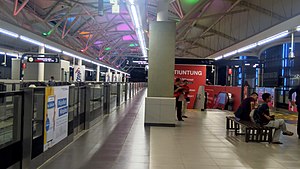
Blok M MRT Station (or Blok M BCA MRT Station, with BCA granted for naming rights) is a rapid transit station on the North-South Line of the Jakarta MRT in Jakarta, Indonesia. The station is located on Jalan Panglima Polim Raya, Melawai, Kebayoran Baru, South Jakarta, between ASEAN and Blok A stations. Unlike other stations on the MRT network, it has three tracks, with two island platforms.

Blok A MRT station
MRT station in Jakarta, Indonesia
Distance: Approx. 1372 meters
Latitude and longitude: -6.2555837,106.797134
Blok A Station is a rapid transit station on the North-South Line of the Jakarta MRT in Jakarta, Indonesia. The station is located on Jalan RS Fatmawati 58, Pulo, Kebayoran Baru, South Jakarta, between Blok M BCA and Haji Nawi stations, and has the station code BLA. The station is close to Blok A of Kebayoran Baru, as well as Blok A market (Pasar Blok A).

Indonesian National Police headquarters shooting
Distance: Approx. 865 meters
Latitude and longitude: -6.23916667,106.80138889
On 31 March 2021, at around 16:30 Western Indonesia Time (UTC+7), a shooting occurred at the Indonesian National Police headquarters in South Jakarta, Jakarta, Indonesia. A female assailant attacked police headquarters with a handgun and was shot dead after firing several rounds. The shooting happened three days after the cathedral bombing in Makassar.

CSW-ASEAN TOD
Public transit interchange station in Jakarta, Indonesia
Distance: Approx. 1051 meters
Latitude and longitude: -6.239085,106.7985954
CSW-ASEAN TOD is a public transit interchange station and transit-oriented development zone between four Transjakarta BRT stations and the ASEAN MRT station on the old Centrale Stichting Wederopbouw (lit. 'Central Foundation for Reconstruction') or CSW intersection at Kebayoran Baru, Jakarta, Indonesia. This building is a circular crossing bridge with an art-deco architecture that connects four Transjakarta BRT stations located to the west, east and south of the intersection and the ASEAN MRT station to the north of the intersection. This building began to open on December 22, 2021 as an operational trial for the integration of integrated highway bus services and integrated highway modes.

Blok M Bus Terminal
Bus terminal in Kebayoran Baru, Jakarta, Indonesia
Distance: Approx. 456 meters
Latitude and longitude: -6.2434937,106.8017898
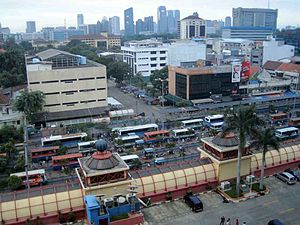
Blok M Terminal is a type-B bus terminal located within the commercial and entertainment quarter of Blok M in Kebayoran Baru, Jakarta, Indonesia. It only serves city transport buses that connects several regions in Jakarta and its surrounding cities. The terminal primarily serves Transjakarta's BRT corridors and feeder routes.
Weather in this IP's area
haze
32 Celsius
37 Celsius
31 Celsius
33 Celsius
1009 hPa
61 %
1009 hPa
1006 hPa
4000 meters
2.57 m/s
120 degree
40 %
05:25:31
17:49:07