Country:
Region:
City:
Latitude and Longitude:
Time Zone:
Postal Code:
IP information under different IP Channel
ip-api
Country
Region
City
ASN
Time Zone
ISP
Blacklist
Proxy
Latitude
Longitude
Postal
Route
Luminati
Country
Region
38
City
saijo
ASN
Time Zone
Asia/Tokyo
ISP
STNet, Incorporated
Latitude
Longitude
Postal
IPinfo
Country
Region
City
ASN
Time Zone
ISP
Blacklist
Proxy
Latitude
Longitude
Postal
Route
db-ip
Country
Region
City
ASN
Time Zone
ISP
Blacklist
Proxy
Latitude
Longitude
Postal
Route
ipdata
Country
Region
City
ASN
Time Zone
ISP
Blacklist
Proxy
Latitude
Longitude
Postal
Route
Popular places and events near this IP address
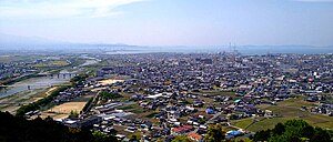
Saijō, Ehime
City in Shikoku, Japan
Distance: Approx. 1968 meters
Latitude and longitude: 33.91666667,133.18333333
Saijō (西条市, Saijō-shi) is a city in Ehime Prefecture, Japan. As of 1 September 2022, the city had an estimated population of 106,016 in 58,803 households and a population density of 210 persons per km2. The total area of the city is 509.98 square kilometres (196.90 sq mi).

Iyo-Saijō Station
Railway station in Saijō, Ehime Prefecture, Japan
Distance: Approx. 2485 meters
Latitude and longitude: 33.9129,133.1873
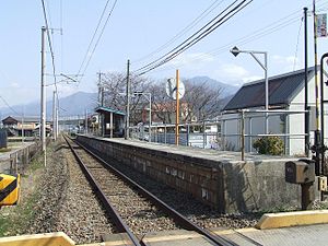
Iyo-Saijō Station (伊予西条駅, Iyo-Saijō-eki) is a passenger railway station located in the city of Saijō, Ehime Prefecture, Japan. It is operated by JR Shikoku and has the station number "Y31". It is the main station of the city of Saijō and a major terminal on the Yosan Line with many train services beginning or ending here.
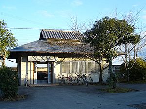
Ishizuchiyama Station
Distance: Approx. 3142 meters
Latitude and longitude: 33.8961,133.158
Ishizuchiyama Station (石鎚山駅, Ishizuchiyama-eki) is a passenger railway station located in the city of Saijō, Ehime Prefecture, Japan. It is operated by JR Shikoku and has the station number "Y32". It is the main station of the city of Saijō and a major terminal on the Yosan Line with many train services beginning or ending here.
Iyo-Himi Station
Railway station in Saijō, Ehime Prefecture, Japan
Distance: Approx. 4288 meters
Latitude and longitude: 33.8968,133.1309
Iyo-Himi Station (伊予氷見駅, Iyo-Himi-eki) is a passenger railway station located in the city of Saijō, Ehime Prefecture, Japan. It is operated by JR Shikoku and has the station number "Y33".
Iyo-Komatsu Station
Railway station in Saijō, Japan
Distance: Approx. 5250 meters
Latitude and longitude: 33.8975,133.1168
Iyo-Komatsu Station (伊予小松駅, Iyo-Komatsu-eki) is a passenger railway station located in the city of Saijō, Ehime Prefecture, Japan. It is operated by JR Shikoku and has the station number "Y34".
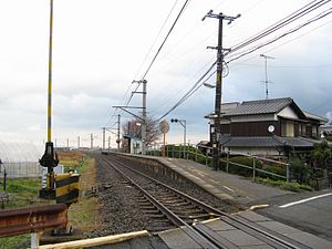
Tamanoe Station
Railway station in Saijō, Ehime Prefecture, Japan
Distance: Approx. 6114 meters
Latitude and longitude: 33.9127,133.0991
Tamanoe Station (玉之江駅, Tamanoe-eki) is a passenger railway station located in the city of Saijō, Ehime Prefecture, Japan. It is operated by JR Shikoku and has the station number "Y35".
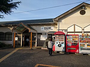
Nyūgawa Station (Ehime)
Railway station in Saijō, Ehime Prefecture, Japan
Distance: Approx. 7258 meters
Latitude and longitude: 33.9295,133.0856
Nyūgawa Station (壬生川駅, Nyūgawa-eki) is a passenger railway station located in the city of Saijō, Ehime Prefecture, Japan. It is operated by JR Shikoku and has the station number "Y36".
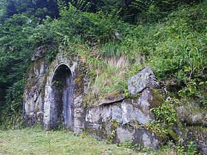
Ichinokawa Mine
Mine in Saijō, Ehime Prefecture, Japan
Distance: Approx. 5338 meters
Latitude and longitude: 33.89166667,133.20666667
The Ichinokawa antimony mine (市之川鉱山, Ichinokawa kōzan) was a prominent source of antimony in Saijō, Ehime Prefecture, Japan. Prized high-quality stibnite crystals produced at the mine can be found in museums and private collections around the world.
Oji-ike Dam
Dam in Ehime Prefecture, Japan
Distance: Approx. 7041 meters
Latitude and longitude: 33.91555556,133.23944444
Oji-ike Dam is an earthfill dam located in Ehime Prefecture in Japan. The dam is used for irrigation. The catchment area of the dam is 5.6 km2.
Shironotani-ike Dam
Dam in Ehime Prefecture, Japan
Distance: Approx. 5474 meters
Latitude and longitude: 33.88527778,133.12722222
Shironotani-ike Dam is an earthfill dam located in Ehime Prefecture in Japan. The dam is used for irrigation. The catchment area of the dam is 2.1 km2.
Hōan-ji temple ruins
Asuka period Buddhist temple ruins
Distance: Approx. 7362 meters
Latitude and longitude: 33.89972222,133.08972222
Hōanji temple ruins (法安寺跡) is an archaeological site with the ruins of a Hakuho period Buddhist temple located in the Komatsu neighbourhood of what is now the city of Saijō, Ehime, Japan. The actual name of the temple is unknown, as it does not appear in historical records, and the site takes its name from a later Shingon temple named Hōan-ji which was built on top its ruins. The Asuka period temple remnants were designated as a National Historic Site in 1944, with the area under designation expanded in 1969.

Isono Shrine
Shinto shrine in Saijo, Japan
Distance: Approx. 3979 meters
Latitude and longitude: 33.89375278,133.18703889
Isono Shrine (伊曽乃神社) is a Shinto shrine located in Saijō, Shikoku, Ehime Prefecture, Japan. It is a Beppyo shrine. It is notable for two different festivals: Saijo Matsuri, and Isono Jinja Sairei.
Weather in this IP's area
overcast clouds
14 Celsius
14 Celsius
14 Celsius
14 Celsius
1024 hPa
72 %
1024 hPa
1023 hPa
10000 meters
1.72 m/s
2.28 m/s
78 degree
100 %
06:34:58
17:07:39
