122.144.28.156 - IP Lookup: Free IP Address Lookup, Postal Code Lookup, IP Location Lookup, IP ASN, Public IP
Country:
Region:
City:
Location:
Time Zone:
Postal Code:
IP information under different IP Channel
ip-api
Country
Region
City
ASN
Time Zone
ISP
Blacklist
Proxy
Latitude
Longitude
Postal
Route
Luminati
Country
ASN
Time Zone
Asia/Bangkok
ISP
True International Gateway Co., Ltd.
Latitude
Longitude
Postal
IPinfo
Country
Region
City
ASN
Time Zone
ISP
Blacklist
Proxy
Latitude
Longitude
Postal
Route
IP2Location
122.144.28.156Country
Region
krung thep maha nakhon
City
din daeng
Time Zone
Asia/Bangkok
ISP
Language
User-Agent
Latitude
Longitude
Postal
db-ip
Country
Region
City
ASN
Time Zone
ISP
Blacklist
Proxy
Latitude
Longitude
Postal
Route
ipdata
Country
Region
City
ASN
Time Zone
ISP
Blacklist
Proxy
Latitude
Longitude
Postal
Route
Popular places and events near this IP address

Royal Thai Army Stadium
Multi-purpose football stadium in Bangkok, Thailand
Distance: Approx. 1734 meters
Latitude and longitude: 13.782661,100.556185
The Royal Thai Army Stadium (Thai: สนามกีฬากองทัพบก) is a multi-purpose stadium on Vibhavadi Rangsit Road in the Phaya Thai of north Bangkok, Thailand. It is currently used mostly for football matches. The stadium holds 20,000 and has a single stand with covered seating on one side and terracing on three sides.
University of the Thai Chamber of Commerce
Private non-profit higher education institution in Bangkok, Thailand
Distance: Approx. 1699 meters
Latitude and longitude: 13.778638,100.56008
The University of the Thai Chamber of Commerce (UTCC) (Thai: มหาวิทยาลัยหอการค้าไทย) is a private non-profit higher education institution in Bangkok, Thailand. The university's origin dates back to 1940, with the foundation of the College of Commerce in Bangkok. In 1984, the college was granted full university status under its present name.
National Defence College of Thailand
Distance: Approx. 1827 meters
Latitude and longitude: 13.779832,100.557165
The National Defence College of Thailand or NDC (Thai: วิทยาลัยป้องกันราชอาณาจักร; RTGS: Witthayalai Pongkan Ratcha-anachak) is an education organization that provides advanced training for both senior military officers and civilians. It is operated by the Royal Thai Armed Forces Headquarters of the Ministry of Defence.
Suan Lum Night Bazaar Ratchadaphisek
Shopping mall in Bangkok, Thailand
Distance: Approx. 1665 meters
Latitude and longitude: 13.8047,100.5746
Suan Lum Night Bazaar Ratchadaphisek or The Bazaar Ratchadaphisek (Thai: สวนลุมไนท์บาซาร์ รัชดาภิเษก) is a mixed-use complex comprising The Bazaar Hotel that accommodates up to 800 rooms, Podstel Hostel Bangkok that hosts over 100 beds, offices, municipal shops, restaurants, a 24-hour supermarket and convenience stores, street food stalls, Bangkok Sky Gym and pool, Top Fight Muay Thai gyms, and a 450-seat theater. Upon completion, the building is one of the longest in length in Bangkok, stretching 1.5 kilometres.
Radio Thailand
National radio broadcaster of Thailand
Distance: Approx. 1451 meters
Latitude and longitude: 13.782137,100.559715
Radio Thailand (Thai: สถานีวิทยุกระจายเสียงแห่งประเทศไทย) is the public broadcasting radio station in Thailand owned by the National Broadcasting Services of Thailand based in Bangkok. The station has six FM national radio, 65 FM provincial radio, three AM national radio, 46 AM provincial radio and World Service. Some Radio Thailand provincial radio stations can be received in neighbor countries of Thailand like Malaysia, Laos, Cambodia and Myanmar.

Huai Khwang MRT station
MRT station on Blue Line in Bangkok, Thailand
Distance: Approx. 1380 meters
Latitude and longitude: 13.7786,100.574
Huai Khwang station (Thai: สถานีห้วยขวาง, pronounced [sā.tʰǎː.nīː hûa̯j kʰwǎːŋ]; code BL18) is a MRT station on the Blue Line in Bangkok, Thailand. It is located under Ratchadaphisek Road, near the MRT Depot. Before the station's opening, the plan was to name it Pracha Rat Bamphen.

Sutthisan MRT station
Mass Rapid Transit station in Thailand
Distance: Approx. 424 meters
Latitude and longitude: 13.79,100.574
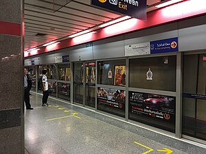
Sutthisan station (Thai: สถานีสุทธิสาร, code BL17) is a Bangkok MRT station on the Blue Line located under Ratchadaphisek Road, near Sutthisan neighbourhood, Bangkok, Thailand. The station's symbol color is red.

Ratchadaphisek MRT station
MRT station in Bangkok
Distance: Approx. 1104 meters
Latitude and longitude: 13.7991,100.575
Ratchadaphisek station (Thai: สถานีรัชดาภิเษก) is a Bangkok MRT station on the Blue Line, located under Ratchadaphisek Road, in Bangkok, Thailand. During construction, the station had been named Ratchada but MRTA changed to Ratchadaphisek, referring to the road of the same name. The station's symbol color is pink.

Lat Phrao MRT station
Subway station in Bangkok, Thailand
Distance: Approx. 1808 meters
Latitude and longitude: 13.8064,100.573
Lat Phrao station (Thai: สถานีลาดพร้าว, pronounced [sā.tʰǎː.nīː lâːt pʰráːw]) is the name of two Bangkok MRT stations, on the Blue Line and Yellow Line, located at the intersection of Ratchadaphisek Road and Lat Phrao Road. It is the northern terminus of the Yellow Line. Although the station's name is Lat Phrao, it is located in Chatuchak district, not Lat Phrao district and Central Plaza Lat Phrao is nearer to Phahon Yothin station.
Asian Network for Free Elections
Independent and nonpartisan non-governmental organization
Distance: Approx. 990 meters
Latitude and longitude: 13.7898237,100.57924245
The Asian Network for Free Elections (ANFREL) is an independent and nonpartisan non-governmental organization working to ensure free and fair elections in Asia, on the basis of universal and equal suffrage. ANFREL is based in Bangkok, Thailand. The alliance was established in November 1997, and includes 27 member organizations across 17 Asian nations, including Afghanistan, Bangladesh, Cambodia, India, Indonesia, Maldives, Mongolia, Myanmar, Nepal, Pakistan, Philippines, Singapore, South Korea, Sri Lanka, Taiwan, Thailand, and Timor-Leste.

Sutthisan Winitchai Road
Road in Bangkok
Distance: Approx. 157 meters
Latitude and longitude: 13.789332,100.569146
Sutthisan Winitchai Road (Thai: ถนนสุทธิสารวินิจฉัย), commonly referred to as Sutthisan Road (ถนนสุทธิสาร) is a road in form of soi (side-street) in downtown Bangkok and is the name of the neighbourhood that the road runs through.

Huai Khwang subdistrict, Bangkok
Khwaeng in Thailand
Distance: Approx. 1756 meters
Latitude and longitude: 13.77819444,100.58038889
Huai Khwang (Thai: ห้วยขวาง, pronounced [hûa̯j kʰwǎːŋ]) is a khwaeng (subdistrict) of Huai Khwang district, downtown Bangkok.
Weather in this IP's area
few clouds
29 Celsius
29 Celsius
28 Celsius
31 Celsius
1009 hPa
45 %
1009 hPa
1008 hPa
10000 meters
3.6 m/s
310 degree
20 %