122.129.203.192 - IP Lookup: Free IP Address Lookup, Postal Code Lookup, IP Location Lookup, IP ASN, Public IP
Country:
Region:
City:
Location:
Time Zone:
Postal Code:
ISP:
ASN:
language:
User-Agent:
Proxy IP:
Blacklist:
IP information under different IP Channel
ip-api
Country
Region
City
ASN
Time Zone
ISP
Blacklist
Proxy
Latitude
Longitude
Postal
Route
db-ip
Country
Region
City
ASN
Time Zone
ISP
Blacklist
Proxy
Latitude
Longitude
Postal
Route
IPinfo
Country
Region
City
ASN
Time Zone
ISP
Blacklist
Proxy
Latitude
Longitude
Postal
Route
IP2Location
122.129.203.192Country
Region
kepulauan riau
City
tanjungpinang
Time Zone
Asia/Jakarta
ISP
Language
User-Agent
Latitude
Longitude
Postal
ipdata
Country
Region
City
ASN
Time Zone
ISP
Blacklist
Proxy
Latitude
Longitude
Postal
Route
Popular places and events near this IP address

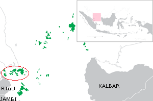
Riau Archipelago
Indonesian archipelago
Distance: Approx. 1859 meters
Latitude and longitude: 0.9,104.45
The Riau Archipelago is a geographic term (as opposed to administrative region) for the core group of islands within the Riau Islands Province in Indonesia, and located south of Singapore and east of Riau on Sumatra. Before the province of Riau Islands was formed, there was no ambiguity in term; however, in Indonesian language, both the archipelago and administrative province are referred to simply as "Kepulauan Riau". The province may have the word "Provinsi" preceding it for clarity.

Tanjungpinang
City and capital of Riau Islands, Indonesia
Distance: Approx. 645 meters
Latitude and longitude: 0.918773,104.455415
Tanjungpinang, also colloquially written as Tanjung Pinang, is the capital city of the Indonesian province of Riau Islands. It covers a land area of 144.56 km2, mainly in the southern part of Bintan Island, as well as other smaller islands such as Dompak Island and Penyengat Island. With a population of 227,663 at the 2020 Census, it is the second largest city of the province, after Batam; the official estimate as at mid 2023 was 234,840 (comprising 118,600 males and 116,250 females).
Grand Mosque of the Sultan of Riau
Mosque in Bintan, Riau Islands, Indonesia
Distance: Approx. 3588 meters
Latitude and longitude: 0.92944444,104.42038889
The Grand Mosque of the Sultan of Riau (Indonesian: Masjid Raya Sultan Riau) on Penyengat Island is located outside Tanjung Pinang on Bintan island, Indonesia. The mosque was built in 1844 and is today one of Tanjung Pinang's most popular attractions for visitors.

Senggarang, Indonesia
Distance: Approx. 6686 meters
Latitude and longitude: 0.96666667,104.41666667
Senggarang is the name of a small village on the island of Bintan, Indonesia, which houses the oldest temple in the Kepri region. Locals believe Senggarang was the first home for Chinese immigrants a long time ago, who then spread throughout the other island of Kepri.
Raja Haji Fisabilillah Airport
Airport in Tanjingpinang, Riau Islands, Indonesia
Distance: Approx. 9175 meters
Latitude and longitude: 0.9225,104.53222222
Raja Haji Fisabilillah Airport (IATA: TNJ, ICAO: WIDN), formerly Kijang Airport, is a domestic airport located in Tanjungpinang, Riau Islands, Indonesia. It is the second largest airport in Riau Islands, after the Hang Nadim International Airport in Batam.

Penyengat Island
Island in Riau Islands, Indonesia
Distance: Approx. 3822 meters
Latitude and longitude: 0.92777778,104.4175
Penyengat Island (Indonesian: Pulau Penyengat, lit. 'wasp island') is an island in Tanjung Pinang, capital of the Riau Islands, Indonesia. It lies just off Bintan Island, close to the downtown of Tanjung Pinang. The island has historical significance, dating back to the 18th century, when it was established as a fort as part of the Sultanate of Johor-Riau by the Bugis people.
Weather in this IP's area
moderate rain
24 Celsius
25 Celsius
24 Celsius
24 Celsius
1011 hPa
90 %
1011 hPa
1009 hPa
10000 meters
3.48 m/s
6.63 m/s
6 degree
100 %
