122.129.125.77 - IP Lookup: Free IP Address Lookup, Postal Code Lookup, IP Location Lookup, IP ASN, Public IP
Country:
 Malaysia
Region:
City:
Location:
Time Zone:
Postal Code:
ISP:
ASN:
language:
User-Agent:
Proxy IP:
Blacklist:
IP information under different IP Channel
ip-api
Country
Region
City
ASN
Time Zone
ISP
Blacklist
Proxy
Latitude
Longitude
Postal
Route
db-ip
Country
Region
City
ASN
Time Zone
ISP
Blacklist
Proxy
Latitude
Longitude
Postal
Route
IPinfo
Country
Region
City
ASN
Time Zone
ISP
Blacklist
Proxy
Latitude
Longitude
Postal
Route
IP2Location
122.129.125.77Country
myRegion
negeri sembilan
City
tampin
Time Zone
Asia/Kuala_Lumpur
ISP
Language
User-Agent
Latitude
Longitude
Postal
ipdata
Country
Region
City
ASN
Time Zone
ISP
Blacklist
Proxy
Latitude
Longitude
Postal
Route
Popular places and events near this IP address

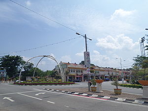
Tampin (town)
Town and district capital in Negeri Sembilan, Malaysia
Distance: Approx. 2330 meters
Latitude and longitude: 2.48972222,102.2375
Tampin is a town in Tampin District, Negeri Sembilan, Malaysia, which borders Pulau Sebang town in Alor Gajah District, Malacca. It is situated at the southern tip of the longest mountain range in Malaysia, the Titiwangsa Mountains. Tampin is located around 60 km south of the state capital city of Seremban and 30 km northwest of Malacca City, Malacca.

Naning
District and former chiefdom in Malacca, Malaysia
Distance: Approx. 6857 meters
Latitude and longitude: 2.4590696,102.1695444
Naning is a district and a former chiefdom in northern Malacca, Malaysia. It is part of the Masjid Tanah constituency and is adjacent to Pulau Sebang. Naning had historically been part of Negeri Sembilan but it was annexed by the British into Malacca in 1832 via the Naning War.
Kota, Negeri Sembilan
Distance: Approx. 8756 meters
Latitude and longitude: 2.517,102.167
Kota (Negeri Sembilan Malay: Koto, Jawi: كوتا) is a small town in Rembau District, Negeri Sembilan, Malaysia, situated along Federal Route 1. The postcode for this small town is 71350. This small town contains a few villages (kampung) such as Kampung Legong Ulu, Kampung Gadong, Kampung Sri Kendong, Kampung Sawah Raja and a few others.

Simpang Ampat (Malacca)
Town in Malaysia in Malacca
Distance: Approx. 6627 meters
Latitude and longitude: 2.43333333,102.18333333
Simpang Ampat or Simpang Empat or Sempang Ampat is a small town in Alor Gajah District, Malacca, Malaysia.

Pulau Sebang
Mukim in Malacca, Malaysia
Distance: Approx. 517 meters
Latitude and longitude: 2.46666667,102.23333333
Pulau Sebang (Negeri Sembilan Malay: Pulau Sobang, Jawi: ڤولاو سبڠ)is a mukim and town in Alor Gajah District, Malacca, Malaysia, which borders Tampin town of Tampin District, Negeri Sembilan.

A' Famosa Resort
Resort in Alor Gajah, Melaka, Malaysia
Distance: Approx. 7321 meters
Latitude and longitude: 2.40505278,102.22051111
A' Famosa Resort Malaysia is a family resort located in Alor Gajah, Malacca, Malaysia, near the Simpang Ampat exit on the North–South Expressway. It was named after the 16th century Portuguese fort of the same name which was once stood near the harbour of Malacca city. The logo of the resort also incorporates a stylized silhouette of the fort's gateway in the background.

Pulau Sebang/Tampin railway station
Railway station in Melaka, Malaysia
Distance: Approx. 836 meters
Latitude and longitude: 2.46333333,102.22694444
The Pulau Sebang/Tampin railway station (formerly Tampin railway station) is a Malaysian train station on the West Coast Line located near and named after the bordering towns of Pulau Sebang, Malacca and Tampin, Negeri Sembilan. The station itself is situated in Malaccan territory, being one of the two stations on the West Coast Line that serves the state of Malacca, the other being Batang Melaka. The station is served by the KTM ETS and KTM Komuter's Seremban Line.

Alor Gajah Square
Square in Alor Gajah, Malacca, Malaysia
Distance: Approx. 9945 meters
Latitude and longitude: 2.38313889,102.20972222
Alor Gajah Square (Malay: Dataran Alor Gajah) or Keris Square (Malay: Dataran Keris) is the town square of Alor Gajah in the Malaysian state of Malacca which features a large bronze sculpture of a kris.

Gadek Hot Spring
Hot spring in Alor Gajah, Melaka, Malaysia
Distance: Approx. 6923 meters
Latitude and longitude: 2.40852778,102.23894444
The Gadek Hot Spring (Malay: Kolam Air Panas Gadek) is a hot spring in Alor Gajah, Melaka, Malaysia.
Alor Gajah
Town and district capital in Malacca, Malaysia
Distance: Approx. 9775 meters
Latitude and longitude: 2.38333333,102.21666667
Alor Gajah is a town and district seat of Alor Gajah District in the Malaysian state of Malacca. It is governed by Alor Gajah Municipal Council (Malay: Majlis Perbandaran Alor Gajah), which was formerly known as Alor Gajah District Council (Malay: Majlis Daerah Alor Gajah) from 1 July 1978 until 1 May 2003.

Mount Tampin
Mountain in Tampin, Negeri Sembilan, Malaysia
Distance: Approx. 4754 meters
Latitude and longitude: 2.5086,102.2117
Mount Tampin (Malay: Gunung Tampin; Jawi: ڬونڠ تمڤين) is a mountain in Tampin District, Negeri Sembilan, Malaysia, close to the border with Malacca. It is the Hausberg of the nearby namesake town, which also serve as the district capital, as well as Pulau Sebang on the Malaccan side.
Weather in this IP's area
overcast clouds
27 Celsius
31 Celsius
27 Celsius
28 Celsius
1008 hPa
83 %
1008 hPa
996 hPa
10000 meters
0.57 m/s
0.71 m/s
353 degree
98 %