122.129.124.158 - IP Lookup: Free IP Address Lookup, Postal Code Lookup, IP Location Lookup, IP ASN, Public IP
Country:
 Malaysia
Region:
City:
Location:
Time Zone:
Postal Code:
ISP:
ASN:
language:
User-Agent:
Proxy IP:
Blacklist:
IP information under different IP Channel
ip-api
Country
Region
City
ASN
Time Zone
ISP
Blacklist
Proxy
Latitude
Longitude
Postal
Route
db-ip
Country
Region
City
ASN
Time Zone
ISP
Blacklist
Proxy
Latitude
Longitude
Postal
Route
IPinfo
Country
Region
City
ASN
Time Zone
ISP
Blacklist
Proxy
Latitude
Longitude
Postal
Route
IP2Location
122.129.124.158Country
myRegion
johor
City
kampung pasir gudang baru
Time Zone
Asia/Kuala_Lumpur
ISP
Language
User-Agent
Latitude
Longitude
Postal
ipdata
Country
Region
City
ASN
Time Zone
ISP
Blacklist
Proxy
Latitude
Longitude
Postal
Route
Popular places and events near this IP address

Masai, Johor
Suburb of Johor Bahru in Johor, Malaysia
Distance: Approx. 1749 meters
Latitude and longitude: 1.48666667,103.885
Masai is an area in Pasir Gudang, Johor Bahru District, Johor, Malaysia, and is the oldest neighbourhood of the city of Johor Bahru. It is located 25 km (15.53 mi) from the Johor Bahru city centre. Masai is located on Jalan Masai Lama (Johor state route J10) which leads to Kong Kong, a fishing village along Johor River.

Pasir Gudang Energy
Malaysian gas turbine power station
Distance: Approx. 2669 meters
Latitude and longitude: 1.4489,103.8816
Sultan Iskandar Power Station (Malay: Stesen Janaelektrik Sultan Iskandar) is a Malaysian gas turbine power station located in Pasir Gudang, Johor.

Pasir Gudang Jamek Mosque
Mosque in Johor Bahru, Johor, Malaysia
Distance: Approx. 2760 meters
Latitude and longitude: 1.47541667,103.90263889
The Pasir Gudang Jamek Mosque (Malay: Masjid Jamek Pasir Gudang) is the first mosque to have been built in Pasir Gudang, Johor, Malaysia. It is located near the lake gardens.
Sembawang Park
Park in Singapore
Distance: Approx. 4792 meters
Latitude and longitude: 1.46104722,103.83652222
Sembawang Park (Chinese: 三巴旺公园; Malay: Taman Sembawang) is a 15-hectare park situated in Sembawang, in the north of Singapore facing the Straits of Johor overlooking Malaysia. It is located at the end of Sembawang Road, where the former Sembawang Road End Bus Terminal was.
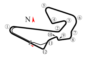
Johor Circuit
Motorsport race track in Johor, Malaysia
Distance: Approx. 3678 meters
Latitude and longitude: 1.48277778,103.90944444
The Johor Circuit was a race track located in Pasir Gudang Johor, Malaysia.

Pasir Gudang Corporation Stadium
Distance: Approx. 2531 meters
Latitude and longitude: 1.461967,103.898102
The Pasir Gudang Corporation Stadium (Malay: Stadium Perbadanan Pasir Gudang) is a multi-use stadium in Pasir Gudang, Johor Bahru District, Johor, Malaysia. It has both an indoor stadium and an outdoor stadium within its compound. The outdoor stadium can hold a maximum of 15,000 people and is currently used mostly for football matches, serving as the home stadium to Johor Darul Ta'zim II F.C. in the Malaysia Premier League.

Bandar Seri Alam
Suburb in Johor Bahru, Johor, Malaysia
Distance: Approx. 4283 meters
Latitude and longitude: 1.51106381,103.87704
Bandar Seri Alam is a township in Mukim Plentong, Johor Bahru District, Johor, Malaysia. It is an initiative by Seri Alam Properties Sdn Bhd, a subsidiary of United Malayan Land Bhd. The township covers approximately 15 square kilometers and houses an ecology educational facilities from school age to campuses of some universities.
Pulau Seletar
Island in Singapore
Distance: Approx. 3759 meters
Latitude and longitude: 1.44255,103.86258983
Pulau Seletar (or Seletar Island) is an island in Singapore waters, in the Straits of Johor off the northern coast. It has an area of 38.5 hectares. It is in a bay into which several streams flow, including the waters of mainland Singapore's only hot spring.

Kite Museum (Johor)
Museum in Johor Bahru, Johor, Malaysia
Distance: Approx. 3170 meters
Latitude and longitude: 1.47497222,103.90638889
The Kite Museum (Malay: Muzium Layang-Layang) is a museum about kites in Pasir Gudang, Johor Bahru District, Johor, Malaysia.
Sungei Simpang Kiri
River in Singapore
Distance: Approx. 3970 meters
Latitude and longitude: 1.4588,103.8451
Sungei Simpang Kiri is a river located in eastern part of Sembawang, Singapore. The river starts near Canberra Link and discharges into the Straits of Johor.

Beaulieu House, Singapore
Distance: Approx. 4695 meters
Latitude and longitude: 1.46339,103.83683
Beaulieu House is a bungalow on Beaulieu Road in Sembawang, Singapore. Initially the holiday residence of a local Jewish family, it later served as the residence of Vice-Admiral Geoffrey Layton.

Sembawang Malay Settlement Mosque
Historic mosque in Singapore
Distance: Approx. 4293 meters
Latitude and longitude: 1.4589456,103.8419259
Masjid Petempatan Melayu Sembawang, also referred to as the Sembawang Malay Settlement Mosque, is a mosque located in Sembawang, in the North Region, Singapore. It was formerly known as the Masjid Kampong Tengah. The mosque is regarded as the last of its kind in Singapore due to it being built in the traditional style of Malay architecture used in older villages (kampong).
Weather in this IP's area
broken clouds
25 Celsius
26 Celsius
23 Celsius
26 Celsius
1010 hPa
80 %
1010 hPa
1007 hPa
10000 meters
3.09 m/s
40 degree
75 %