Country:
Region:
City:
Latitude and Longitude:
Time Zone:
Postal Code:
IP information under different IP Channel
ip-api
Country
Region
City
ASN
Time Zone
ISP
Blacklist
Proxy
Latitude
Longitude
Postal
Route
Luminati
Country
City
singapore
ASN
Time Zone
Asia/Singapore
ISP
StarHub Ltd
Latitude
Longitude
Postal
IPinfo
Country
Region
City
ASN
Time Zone
ISP
Blacklist
Proxy
Latitude
Longitude
Postal
Route
db-ip
Country
Region
City
ASN
Time Zone
ISP
Blacklist
Proxy
Latitude
Longitude
Postal
Route
ipdata
Country
Region
City
ASN
Time Zone
ISP
Blacklist
Proxy
Latitude
Longitude
Postal
Route
Popular places and events near this IP address
Yishun
Planning Area and HDB Town in North Region, Singapore
Distance: Approx. 579 meters
Latitude and longitude: 1.43,103.835
Yishun ( EE-shoon), formerly known as Nee Soon, is a residential town located in the northeastern corner of the North Region of Singapore, bordering Simpang and Sembawang to the north, Mandai to the west, the Central Water Catchment to its southwest, Ang Mo Kio to its south, as well as Seletar and Sengkang to its east and southeast respectively.

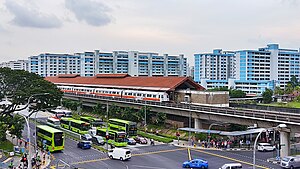
Yishun MRT station
Mass Rapid Transit station in Singapore
Distance: Approx. 639 meters
Latitude and longitude: 1.42946389,103.83523889
Yishun MRT station is an above-ground Mass Rapid Transit (MRT) station on the North South line (NSL) in Yishun, Singapore. The station is located at the junction of Yishun Avenue 2 and Yishun Avenue 5, and is currently one of the two MRT stations that serve Yishun New Town; the other being Khatib station. Yishun station was the terminus of the NSL upon its completion on 20 December 1988, until the Woodlands Extension of the NSL was completed and opened on 10 February 1996.
GV Yishun
Distance: Approx. 714 meters
Latitude and longitude: 1.42988889,103.83641667
GV Yishun, formerly Yishun 10, is Asia's first multiplex.

Northpoint City
Shopping mall in Yishun, Singapore
Distance: Approx. 809 meters
Latitude and longitude: 1.42816667,103.83611111
Northpoint City, formerly known as Northpoint Shopping Centre, is a suburban shopping mall in Yishun, Singapore. Located opposite Yishun MRT station, the mall houses the Nee Soon Central Community Club, Yishun Public Library as well as the Yishun Bus Interchange, which forms part of the Yishun Integrated Transport Hub (ITH). The mall was first opened in 1992, and was renovated and expanded in 2008.

Yishun Bus Interchange
Bus interchange in Yishun, Singapore
Distance: Approx. 840 meters
Latitude and longitude: 1.42758333,103.83588889
Yishun Bus Interchange is a bus interchange primarily serving residents in Yishun in northern Singapore, integrated with the Northpoint City shopping mall. The interchange, also referred to as “Yishun Integrated Transport Hub (ITH)” opened on 8 September 2019.
Church of Our Lady Star of the Sea
Distance: Approx. 683 meters
Latitude and longitude: 1.4372963,103.8356825
The Church of Our Lady Star of the Sea is a Roman Catholic church in Singapore and comes under the jurisdiction of the Archdiocese of Singapore. The church is located at Yishun Street 22.
Chong Pang Camp
Distance: Approx. 652 meters
Latitude and longitude: 1.43215278,103.82526389
Chong Pang Camp is located in the northern side of Singapore, within Sembawang Air Base and opposite Chong Pang City in Yishun. Established in 2002, the camp is operated by the Republic of Singapore Air Force (RSAF). The camp houses elements from Air Defence Operations Command (HQ ADOC, 165 Squadron, 809 and 819 Squadrons and 9 Air Engineering and Logistics Group) and Participation Command (HQ PC, 3DA, 6/9 DA and 18 DA Battalions, 105 Squadron and 1 Medical Squadron).

Masjid Darul Makmur
Mosque in Yishun, Singapore
Distance: Approx. 533 meters
Latitude and longitude: 1.4368,103.8343
The Darul Makmur Mosque (Malay: Masjid Darul Makmur) is a mosque located at Yishun Avenue 2 in Yishun, Singapore. It was constructed in the early 1980s.
Yishun Public Library
Public library in Singapore
Distance: Approx. 809 meters
Latitude and longitude: 1.42816667,103.83611111
Yishun Public Library (Simplified Chinese: 义顺社区图书馆), is a public library located in Yishun in the North Region of Singapore. It is currently located at Level 4, North Wing of Northpoint City and serves the areas of Yishun, Khatib and Canberra. The target community includes residents of Chong Pang, Nee Soon Central, Nee Soon East and Nee Soon South.
Ahmad Ibrahim Secondary School
Government school in Singapore
Distance: Approx. 341 meters
Latitude and longitude: 1.43611111,103.82972222
Ahmad Ibrahim Secondary School (AISS) is a co-educational government secondary school in Singapore. Founded in 1962, it was the second integrated school to be established in Singapore. The school is named after Ahmad Ibrahim, Singapore's first Health Minister who was remembered for "garnering the support of all races at a time when communal relations were sensitive and volatile".
Yishun Neighbourhood Park
Park located in Yishun, Singapore
Distance: Approx. 560 meters
Latitude and longitude: 1.4379,103.8331
Yishun Neighbourhood Park is a park located in Yishun, Singapore. The 7.7 hectares park was developed on an old rubber estate and features a hill with an open lawn, ideal for picnics. Facilities include children's playground and fitness equipment.

Sir Manasseh Meyer International School
International school in Singapore
Distance: Approx. 875 meters
Latitude and longitude: 1.43703,103.82406
Sir Manasseh Meyer International School (SMMIS) is a not-for-profit co-educational international school in Singapore for children aged 18 months to 16 years. The Sir Manasseh Meyer Trust supports the school with an annual grant.
Weather in this IP's area
broken clouds
26 Celsius
27 Celsius
25 Celsius
27 Celsius
1011 hPa
92 %
1011 hPa
1008 hPa
10000 meters
1.03 m/s
40 degree
75 %
06:46:18
18:50:05
