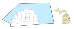
Country:
Region:
City:
Latitude and Longitude:
Time Zone:
Postal Code:
IP information under different IP Channel
ip-api
Country
Region
City
ASN
Time Zone
ISP
Blacklist
Proxy
Latitude
Longitude
Postal
Route
Luminati
Country
Region
mi
City
pigeon
ASN
Time Zone
America/Detroit
ISP
AGRI-VALLEY
Latitude
Longitude
Postal
IPinfo
Country
Region
City
ASN
Time Zone
ISP
Blacklist
Proxy
Latitude
Longitude
Postal
Route
db-ip
Country
Region
City
ASN
Time Zone
ISP
Blacklist
Proxy
Latitude
Longitude
Postal
Route
ipdata
Country
Region
City
ASN
Time Zone
ISP
Blacklist
Proxy
Latitude
Longitude
Postal
Route
Popular places and events near this IP address

Brookfield Township, Huron County, Michigan
Civil township in Michigan, United States
Distance: Approx. 9194 meters
Latitude and longitude: 43.7325,-83.28694444
Brookfield Township is a civil township of Huron County in the U.S. state of Michigan. As of the 2020 census, the township population was 739.

Elkton, Michigan
Village in Michigan, United States
Distance: Approx. 7104 meters
Latitude and longitude: 43.81888889,-83.18111111
Elkton is a village in Huron County in the U.S. state of Michigan. The population was 796 at the 2020 census. The village is within Oliver Township, along the Pinnebog River.

McKinley Township, Huron County, Michigan
Civil township in Michigan, United States
Distance: Approx. 7075 meters
Latitude and longitude: 43.87305556,-83.30222222
McKinley Township is a civil township of Huron County in the U.S. state of Michigan. The population was 401 at the 2020 census.

Oliver Township, Huron County, Michigan
Civil township in Michigan, United States
Distance: Approx. 7153 meters
Latitude and longitude: 43.81555556,-83.18027778
Oliver Township is a civil township of Huron County in the U.S. state of Michigan. The population was 1,419 at the 2020 census.

Owendale, Michigan
Village in Michigan, United States
Distance: Approx. 9455 meters
Latitude and longitude: 43.72916667,-83.26805556
Owendale is a village in Huron County of the U.S. state of Michigan. The population was 241 at the 2010 census. The village is within Brookfield Township.

Pigeon, Michigan
Village in Michigan, United States
Distance: Approx. 1752 meters
Latitude and longitude: 43.82972222,-83.27194444
Pigeon is a village in Huron County in the U.S. state of Michigan. The population was 1,208 at the 2010 census. The village is within Winsor Township.

Winsor Township, Michigan
Civil township in Michigan, United States
Distance: Approx. 1018 meters
Latitude and longitude: 43.81472222,-83.28194444
Winsor Township is a civil township of Huron County in the U.S. state of Michigan. The population was 1,960 at the 2020 census.

Bay Port, Michigan
Census-designated place & unincorporated community in Michigan, United States
Distance: Approx. 9201 meters
Latitude and longitude: 43.84916667,-83.37305556
Bay Port is an unincorporated community and census-designated place (CDP) in Huron County in the U.S. state of Michigan. The population was 582 at the 2020 census. As an unincorporated community, Bay Port has no legal autonomy of its own but does have its own post office with the 48720 ZIP Code.
Kilmanagh, Michigan
Unincorporated community in Michigan, United States
Distance: Approx. 9554 meters
Latitude and longitude: 43.75611111,-83.35694444
Kilmanagh is an unincorporated community in Huron County in the U.S. state of Michigan.

Bay Port Historic Commercial Fishing District
United States historic place
Distance: Approx. 9475 meters
Latitude and longitude: 43.85388889,-83.37361111
The Bay Port Historic Commercial Fishing District is a commercial fishing historic district located on Lakeside Drive and First Street adjacent to Saginaw Bay in Bay Port, Michigan. The district was listed on the National Register of Historic Places in 1977.
Weather in this IP's area
overcast clouds
6 Celsius
2 Celsius
6 Celsius
7 Celsius
1018 hPa
78 %
1018 hPa
995 hPa
10000 meters
6.92 m/s
14.07 m/s
136 degree
100 %
07:25:43
17:09:22