Country:
 South Korea
Region:
City:
Latitude and Longitude:
Time Zone:
Postal Code:
IP information under different IP Channel
ip-api
Country
Region
City
ASN
Time Zone
ISP
Blacklist
Proxy
Latitude
Longitude
Postal
Route
IPinfo
Country
Region
City
ASN
Time Zone
ISP
Blacklist
Proxy
Latitude
Longitude
Postal
Route
MaxMind
Country
Region
City
ASN
Time Zone
ISP
Blacklist
Proxy
Latitude
Longitude
Postal
Route
Luminati
Country
KRRegion
11
City
gwangjingu
ASN
Time Zone
Asia/Seoul
ISP
DLIVE
Latitude
Longitude
Postal
db-ip
Country
Region
City
ASN
Time Zone
ISP
Blacklist
Proxy
Latitude
Longitude
Postal
Route
ipdata
Country
Region
City
ASN
Time Zone
ISP
Blacklist
Proxy
Latitude
Longitude
Postal
Route
Popular places and events near this IP address
Achasanseong
Distance: Approx. 1289 meters
Latitude and longitude: 37.55617778,127.10470556
Achasanseong Fortress is an earthen mountain fortress dating from the Korean Three Kingdoms period. Originally built by Baekje, it was occupied in turn by each of the Three Kingdoms. It stands on Achasan Mountain, in Gwangjin-gu, Seoul, South Korea, at an altitude of 200 meters above sea level.

Guui station
Train station in South Korea
Distance: Approx. 1329 meters
Latitude and longitude: 37.53805556,127.08583333
Guui Station (Korean: 구의역) is a station on the Seoul Subway Line 2. Because of its proximity to the Gwangjin District Office (close to exit number 1), it is also known as Gwangjin-gu Office Station.

Konkuk University
University in South Korea
Distance: Approx. 1803 meters
Latitude and longitude: 37.54194444,127.07638889
Konkuk University (Korean: 건국대학교; Hanja: 建國大學校) is a South Korean private university founded in 1931 and it is one of the top universities in South Korea. The university was founded based on three virtues: sincerity, fidelity, and righteousness. Konkuk University gives comprehensive education in agricultural and life science research to around 30,000 students, plus 2,500 international students.
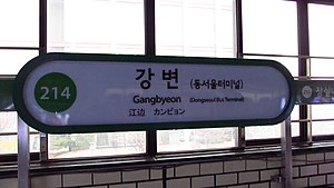
Gangbyeon station
Train station in South Korea
Distance: Approx. 1339 meters
Latitude and longitude: 37.535,127.09472222
Gangbyeon Station (Korean: 강변역) is a station on the Seoul Subway Line 2. The name of this station literally means "riverside," pertaining to its proximity to the Han River.
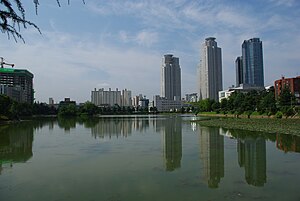
Gwangjin District
Autonomous district in Seoul, South Korea
Distance: Approx. 1650 meters
Latitude and longitude: 37.537,127.082
Gwangjin District (Korean: 광진구; Hanja: 廣津區; RR: Gwangjin-gu) is one of the 25 districts of Seoul, South Korea. It is located on the north bank of the Han River on the eastern end of Seoul. The district was split from the neighboring Seongdong District in 1995.
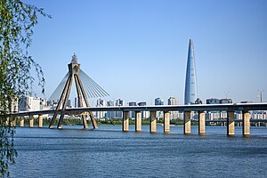
Olympic Bridge
Bridge in Seoul, South Korea
Distance: Approx. 1614 meters
Latitude and longitude: 37.534,127.1039
The Olympic Bridge (Korean: 올림픽대교), also known as the Grand Olympic Bridge, is a bridge over the Han River in Seoul, South Korea. The bridge links the Gwangjin and Songpa districts.

Achasan station
Station of the Seoul Metropolitan Subway
Distance: Approx. 778 meters
Latitude and longitude: 37.551983,127.089626
Achasan (Korean: 아차산; Hanja: 峨嵯山), also known as Rear Entrance to Seoul Children's Grand Park, is a subway station on Line 5 of the Seoul Metropolitan Subway. Located in Gwangjin-gu, in Seoul, South Korea the station is near the rear entrance of Seoul Children's Grand Park.

Gwangnaru station
Train station in South Korea
Distance: Approx. 716 meters
Latitude and longitude: 37.54527778,127.10361111
Gwangnaru Station is a station on the Seoul Subway Line 5 in Gwangjin-gu, Seoul. Its station subname is Presbyterian Univ. & Theological Seminary, where said university is nearby Exit 2.

Gwangjin Bridge
Bridge in Seoul, South Korea
Distance: Approx. 1544 meters
Latitude and longitude: 37.54472222,127.11305556
The Gwangjin Bridge (Korean: 광진교) crosses the Han River in South Korea and connects the districts of Gwangjin-gu and Gangdong-gu. The original bridge was completed in 1936, but because of deteriorating conditions, it was rebuilt and reopened in November 2003.

Cheonho Bridge
Bridge in Seoul, South Korea
Distance: Approx. 1508 meters
Latitude and longitude: 37.54287778,127.11207222
The Cheonho Bridge crosses the Han River in Seoul, South Korea. It connects Gangdong District and Gwangjin District. The bridge was completed on July 5, 1976.

Children's Grand Park, Seoul
Family leisure facility in South Korea
Distance: Approx. 1399 meters
Latitude and longitude: 37.546,127.08
Children's Grand Park (Korean: 어린이대공원) or Seoul Children's Grand Park is a park complex in Gwangjin-gu, Seoul, South Korea. Facilities at Children's Grand Park include hills and hiking trails, Zoo, garden, and an amusement park. Children's Grand Park is a leisure facility for families, offering a botanical garden, amusement facilities, and diverse performance events.
International Mongolia School
Distance: Approx. 273 meters
Latitude and longitude: 37.5455,127.09824
The International Mongolia School (Korean: 재한 몽골 학교) is a Mongolian international school in Gwangjin-gu, Seoul, South Korea. It serves levels primary school through high school.
Weather in this IP's area
broken clouds
24 Celsius
25 Celsius
22 Celsius
25 Celsius
1016 hPa
86 %
1016 hPa
1011 hPa
10000 meters
0.6 m/s
0.68 m/s
88 degree
64 %
06:15:11
18:37:17