121.59.17.136 - IP Lookup: Free IP Address Lookup, Postal Code Lookup, IP Location Lookup, IP ASN, Public IP
Country:
 Kazakhstan
Region:
City:
Location:
Time Zone:
Postal Code:
ISP:
ASN:
language:
User-Agent:
Proxy IP:
Blacklist:
IP information under different IP Channel
ip-api
Country
Region
City
ASN
Time Zone
ISP
Blacklist
Proxy
Latitude
Longitude
Postal
Route
db-ip
Country
Region
City
ASN
Time Zone
ISP
Blacklist
Proxy
Latitude
Longitude
Postal
Route
IPinfo
Country
Region
City
ASN
Time Zone
ISP
Blacklist
Proxy
Latitude
Longitude
Postal
Route
IP2Location
121.59.17.136Country
kzRegion
almaty oblysy
City
kaskelen
Time Zone
Asia/Almaty
ISP
Language
User-Agent
Latitude
Longitude
Postal
ipdata
Country
Region
City
ASN
Time Zone
ISP
Blacklist
Proxy
Latitude
Longitude
Postal
Route
Popular places and events near this IP address
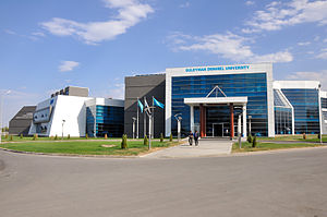
Suleyman Demirel University
Distance: Approx. 3340 meters
Latitude and longitude: 43.208,76.67
SDU University is an international and private university in Kaskelen, Almaty, Kazakhstan. It is named after Süleyman Demirel, the former prime minister and president of Turkey. The university was established in 1996, by the initiatives of the former president of Kazakhstan, Nursultan Nazarbayev, and the former president of Turkey, Süleyman Demirel.

Karasay District
District in Almaty Region, Kazakhstan
Distance: Approx. 779 meters
Latitude and longitude: 43.1994,76.6215
Karasay District (Kazakh: Қарасай ауданы, Qarasay awdany; Russian: Карасайский район, former Kaskelen District) is a district of Almaty Region in Kazakhstan. The administrative center of the district is the town of Kaskelen. Population: 280,939 (2013 estimate); 247,616 (2009 Census results); 154,602 (1999 Census results).

Kaskelen
Town in Almaty Region, Kazakhstan
Distance: Approx. 910 meters
Latitude and longitude: 43.2,76.62
Kaskelen (Kazakh: Қаскелең, Qaskeleñ) is a town and seat of Karasay District in Almaty Region of south-eastern Kazakhstan. Population: 58,418 (2009 Census results); 37,221 (1999 Census results). The city contains Suleyman Demirel University.

Aeroflot Flight 5463
1983 aviation accident
Distance: Approx. 6360 meters
Latitude and longitude: 43.1689,76.6981
Aeroflot Flight 5463 was a Soviet domestic passenger flight from Chelyabinsk to Almaty which crashed on 30 August 1983 while approaching Almaty. The Tupolev Tu-134A collided with the western slope of Dolan Mountain at an altitude of 690 m (2,260 ft). As a result of the accident, all ninety people on board were killed.
Äitei, Almaty
Village in Almaty, Kazakhstan
Distance: Approx. 4620 meters
Latitude and longitude: 43.23222222,76.598
Äitei (Kazakh: Әйтей), known as Internatsional (Интернационал) until 1992, is a village in the Karasay District of the Almaty Region in Kazakhstan. It is located about 5 km northwest of Kaskelen.
Weather in this IP's area
overcast clouds
1 Celsius
-2 Celsius
1 Celsius
1 Celsius
1031 hPa
93 %
1031 hPa
893 hPa
10000 meters
2.28 m/s
3.18 m/s
72 degree
100 %