Country:
Region:
City:
Latitude and Longitude:
Time Zone:
Postal Code:
IP information under different IP Channel
ip-api
Country
Region
City
ASN
Time Zone
ISP
Blacklist
Proxy
Latitude
Longitude
Postal
Route
Luminati
Country
ASN
Time Zone
Asia/Tokyo
ISP
SECOM Trust Systems Co.,Ltd.
Latitude
Longitude
Postal
IPinfo
Country
Region
City
ASN
Time Zone
ISP
Blacklist
Proxy
Latitude
Longitude
Postal
Route
db-ip
Country
Region
City
ASN
Time Zone
ISP
Blacklist
Proxy
Latitude
Longitude
Postal
Route
ipdata
Country
Region
City
ASN
Time Zone
ISP
Blacklist
Proxy
Latitude
Longitude
Postal
Route
Popular places and events near this IP address
Mitaka, Tokyo
City in Kantō, Japan
Distance: Approx. 606 meters
Latitude and longitude: 35.68355556,139.55952778
Mitaka (三鷹市, Mitaka-shi) is a city in the Western Tokyo region of Tokyo Metropolis, Japan. As of 1 March 2021, the city had an estimated population of 190,403, and a population density of 12,000 persons per km2. The total area of the city was 16.42 square kilometres (6.34 sq mi).

Ghibli Museum
Art museum in Mitaka, Tokyo, Japan
Distance: Approx. 1169 meters
Latitude and longitude: 35.69623333,139.57043056
The Ghibli Museum (三鷹の森ジブリ美術館, Mitaka no Mori Jiburi Bijutsukan, Mitaka Forest Ghibli Museum) is a museum showcasing the work of the Japanese animation studio Studio Ghibli. It is located in Inokashira Park in Mitaka, a western city of Tokyo, Japan. The museum combines features of a children's museum, technology museum, and a fine arts museum, and is dedicated to the art and technique of animation.

Inokashira Park
Park in Tokyo, Japan
Distance: Approx. 1778 meters
Latitude and longitude: 35.70083333,139.57416667
Inokashira Park (井の頭恩賜公園, Inokashira Onshi Kōen) is a park which straddles Musashino and Mitaka in western Tokyo, Japan. Inokashira Pond (井の頭池) and the Kanda River water source (神田上水, Kanda jōsui), established during the Edo period, are the primary sources of the Kanda River. The land was given to Tokyo in 1913.

Mitaka Station
Railway station in Mitaka, Tokyo, Japan
Distance: Approx. 1829 meters
Latitude and longitude: 35.70277778,139.56083333
Mitaka Station (三鷹駅, Mitaka-eki) is a passenger railway station located in the city of Mitaka, Tokyo, Japan, operated by the East Japan Railway Company (JR East). Part of the station (north of the Tamagawa Aqueduct) is located in the Nakacho neighborhood of Musashino, Tokyo.
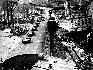
Mitaka incident
1949 railway accident in Tokyo, Japan
Distance: Approx. 1829 meters
Latitude and longitude: 35.70277778,139.56083333
The Mitaka incident (三鷹事件, Mitaka jiken) was an incident that took place in Tokyo, Japan on July 15, 1949, when an unmanned 63 series train with its operating handle tied down drove into Mitaka Station on the Chūō Line, killing six people and injuring 20. The incident remains a mystery, as do the Shimoyama and Matsukawa incidents which occurred around the same time. The government indicted ten people on a charge of train sabotage resulting in death of the victims, as well as the train's conductor, Keisuke Takeuchi, who was not in the train when it derailed.

Inokashira-kōen Station
Railway station in Mitaka, Tokyo, Japan
Distance: Approx. 2002 meters
Latitude and longitude: 35.6975,139.5827
Inokashira-kōen Station (井の頭公園駅, Inokashira-kōen-eki) is a passenger railway station located in the city of Mitaka, Tokyo, Japan, operated by the private railway operator Keio Corporation.

Kichijōji Station
Railway station in Musashino, Tokyo, Japan
Distance: Approx. 2230 meters
Latitude and longitude: 35.70277778,139.57972222
Kichijōji Station (吉祥寺駅, Kichijōji-eki) is an interchange passenger railway station serving Kichijōji in the city of Musashino, Tokyo, Japan, operated by East Japan Railway Company (JR East) and the private railway operator Keio Corporation.
Kyorin University
Distance: Approx. 1089 meters
Latitude and longitude: 35.67694444,139.56583333
Kyorin University (杏林大学, Kyōrin daigaku) is a private university in the western part of Tokyo, Japan. Its three campuses are in Mitaka and Hachiōji, Tokyo. It was established in 1970.

St. Margaret's Junior College
Women's junior college in Tokyo
Distance: Approx. 2228 meters
Latitude and longitude: 35.69338889,139.58822222
St.Margaret's Junior College (立教女学院短期大学, Rikkyō jogakuin tanki daigaku) was a private women's junior college in Suginami, Tokyo, Japan. It was abolished in 2020.
Chofu Aerospace Center
Development facility of JAXA
Distance: Approx. 1057 meters
Latitude and longitude: 35.6787,139.5587
Chōfu Aerospace Center (調布航空宇宙センター, Chōfu Kōkū-uchū senta) is the headquarters and main development facility for the Japan Aerospace Exploration Agency (JAXA). The Chōfu Aerospace Center concentrates on aerospace engineering research and development, and is equipped with test facilities including several wind tunnels, materials test facilities, flight simulators, engine test stands and a supercomputer.
Musashi International School Tokyo
Private co-educational school
Distance: Approx. 471 meters
Latitude and longitude: 35.6879,139.56
Musashi International School Tokyo (MIST), formerly Little Angels International School and Academy (LAIS リトルエンジェルス・インターナショナルスクール; formerly リトルエンジェルス学園 Ritoru Enjerusu Gakuen), is an international school, kindergarten, English school, and adult business school with two campuses located in Mitaka, Tokyo, Japan. It was designed to cater to Japanese children, whereas other Indian international schools in Japan were established mainly for Indian children.

Inokashira Park Zoo
Zoo in Tokyo, Japan
Distance: Approx. 1722 meters
Latitude and longitude: 35.70083306,139.57275
Inokashira Park Zoo (Japanese: いのかしらしぜんぶんかえん; Kanji: 井の頭自然文化園) is a city zoo in Musashino, Tokyo. It is in a corner of Inokashira Park near the Ghibli Museum. A branch of the zoo is in Mitaka.
Weather in this IP's area
overcast clouds
15 Celsius
15 Celsius
14 Celsius
16 Celsius
1022 hPa
87 %
1022 hPa
1015 hPa
10000 meters
4.19 m/s
9 m/s
42 degree
98 %
06:18:37
16:34:38


