Country:
 Australia
Region:
City:
Latitude and Longitude:
Time Zone:
Postal Code:
IP information under different IP Channel
ip-api
Country
Region
City
ASN
Time Zone
ISP
Blacklist
Proxy
Latitude
Longitude
Postal
Route
IPinfo
Country
Region
City
ASN
Time Zone
ISP
Blacklist
Proxy
Latitude
Longitude
Postal
Route
MaxMind
Country
Region
City
ASN
Time Zone
ISP
Blacklist
Proxy
Latitude
Longitude
Postal
Route
Luminati
Country
AURegion
wa
City
perth
ASN
Time Zone
Australia/Perth
ISP
Pentanet Limited
Latitude
Longitude
Postal
db-ip
Country
Region
City
ASN
Time Zone
ISP
Blacklist
Proxy
Latitude
Longitude
Postal
Route
ipdata
Country
Region
City
ASN
Time Zone
ISP
Blacklist
Proxy
Latitude
Longitude
Postal
Route
Popular places and events near this IP address

Marangaroo, Western Australia
Suburb of Perth, Western Australia
Distance: Approx. 2151 meters
Latitude and longitude: -31.828,115.836
Marangaroo is a suburb of Perth, Western Australia. It is located approximately 18 km north of Perth City, within the City of Wanneroo. Marangaroo's borders comprise Wanneroo Road, Hepburn Avenue, Mirrabooka Avenue and Marangaroo Drive.

Division of Cowan
Australian federal electoral division
Distance: Approx. 3229 meters
Latitude and longitude: -31.782,115.846
The Division of Cowan () is an Australian Electoral Division in Western Australia. Cowan is an inner-northern Perth seat lying generally between Morley Drive and Hepburn Avenue, extending from the Mitchell Freeway in the west to the Tonkin Highway and Lord Street in the east. Cowan is a marginal seat that leans toward the Australian Labor Party.

Alexander Heights, Western Australia
Suburb of Perth, Western Australia
Distance: Approx. 2900 meters
Latitude and longitude: -31.827,115.871
Alexander Heights is a suburb of Perth, Western Australia within the City of Wanneroo. Originally named in 1977 as "Alinjarra", an Aboriginal word for "north", this suburb was renamed Alexander Heights in 1987. The name is derived from Alexander Drive, the main arterial road into the area, which forms the suburb's eastern boundary.
Darch, Western Australia
Suburb of Perth, Western Australia
Distance: Approx. 135 meters
Latitude and longitude: -31.812,115.846
Darch is a suburb of Perth, Western Australia, located within the City of Wanneroo approximately 17 kilometres (11 mi) north of the central business district. Previously part of Landsdale, much of the suburb was rural in character until the late 1990s. It was named after an early settler family in the area, with the name being approved in 1997.
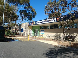
Girrawheen, Western Australia
Suburb of Perth, Western Australia
Distance: Approx. 3115 meters
Latitude and longitude: -31.836,115.832
Girrawheen is a northern suburb of Perth, the capital city of Western Australia. Its local government area is the City of Wanneroo.
Koondoola, Western Australia
Suburb of Perth, Western Australia
Distance: Approx. 3639 meters
Latitude and longitude: -31.842,115.859
Koondoola is a suburb of Perth, Western Australia, located within the City of Wanneroo. Its postcode is 6064. Most of Koondoola's infrastructure was built in the 1970s.
Landsdale, Western Australia
Suburb of Perth, Western Australia
Distance: Approx. 771 meters
Latitude and longitude: -31.809,115.839
Landsdale is a northern suburb of Perth, Western Australia located within the local government area of the City of Wanneroo. It is mixed use, with residential, commercial and light manufacturing areas.

Madeley, Western Australia
Suburb of Perth, Western Australia
Distance: Approx. 1778 meters
Latitude and longitude: -31.811,115.828
Madeley is a suburb of Perth, the capital city of Western Australia 20 kilometres (12 mi) north of Perth's central business district. Its local government area is the City of Wanneroo. Previously part of Landsdale, much of the suburb was rural in character until the 1990s, with market gardening a common activity.

Wangara, Western Australia
Suburb of Perth, Western Australia
Distance: Approx. 2792 meters
Latitude and longitude: -31.791,115.829
Wangara is a light industrial suburb of Perth, Western Australia, located within the City of Wanneroo. Wangara is one of Perth's busiest industrial areas. It is situated roughly 20 km north of the central business district, and is the industrial hub of the north side of Perth.

Swan Coastal Plain
Bioregion in Western Australia
Distance: Approx. 1191 meters
Latitude and longitude: -31.82,115.84
The Swan Coastal Plain in Western Australia is the geographic feature which contains the Swan River as it travels west to the Indian Ocean. The coastal plain continues well beyond the boundaries of the Swan River and its tributaries, as a geological and biological zone, one of Western Australia's Interim Biogeographic Regionalisation for Australia regions. It is also one of the distinct physiographic provinces of the larger West Australian Shield division.
Ashdale Secondary College
School in Perth, Western Australia
Distance: Approx. 530 meters
Latitude and longitude: -31.8112,115.8412
Ashdale Secondary College is an Independent Public secondary school in the Perth suburb of Darch, Western Australia. Established in 2009, the school has specialist programs for Information and Communication Technology (ICT) and for Autism Extension (AEP).
Girrawheen Senior High School
School in Australia
Distance: Approx. 2924 meters
Latitude and longitude: -31.83694444,115.84194444
Girrawheen Senior High School is an independent public co-educational high day school, located in the Perth suburb of Girrawheen, Western Australia.
Weather in this IP's area
broken clouds
23 Celsius
23 Celsius
23 Celsius
25 Celsius
1014 hPa
66 %
1014 hPa
1008 hPa
10000 meters
5.14 m/s
270 degree
75 %
05:32:15
18:30:34