Country:
 Malaysia
Region:
City:
Latitude and Longitude:
Time Zone:
Postal Code:
IP information under different IP Channel
ip-api
Country
Region
City
ASN
Time Zone
ISP
Blacklist
Proxy
Latitude
Longitude
Postal
Route
IPinfo
Country
Region
City
ASN
Time Zone
ISP
Blacklist
Proxy
Latitude
Longitude
Postal
Route
MaxMind
Country
Region
City
ASN
Time Zone
ISP
Blacklist
Proxy
Latitude
Longitude
Postal
Route
Luminati
Country
MYRegion
10
City
petalingjaya
ASN
Time Zone
Asia/Kuala_Lumpur
ISP
Binariang Berhad
Latitude
Longitude
Postal
db-ip
Country
Region
City
ASN
Time Zone
ISP
Blacklist
Proxy
Latitude
Longitude
Postal
Route
ipdata
Country
Region
City
ASN
Time Zone
ISP
Blacklist
Proxy
Latitude
Longitude
Postal
Route
Popular places and events near this IP address
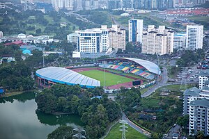
Petaling Jaya Stadium
Distance: Approx. 2425 meters
Latitude and longitude: 3.098709,101.593768
The Petaling Jaya Stadium, also known as the MBPJ Stadium is a multi-purpose stadium in the suburb of Kelana Jaya in Petaling Jaya, Selangor, Malaysia. The stadium was opened in 1996 and has a capacity of 25,000. It was built in time for the 1998 Commonwealth Games and hosted the Games' rugby union matches.

Kelana Jaya LRT station
Railway station in Malaysia
Distance: Approx. 1265 meters
Latitude and longitude: 3.1125,101.60388889
Kelana Jaya LRT station is a light rail station on the Kelana Jaya Line. It was the former western terminus for passenger services on the line. It is the start of the LRT Extension Project which extended the current terminus to Putra Heights station.

Taman Paramount LRT station
Distance: Approx. 1060 meters
Latitude and longitude: 3.10444444,101.62305556
Taman Paramount LRT station is an LRT station in Petaling Jaya that is served by rapidKL's Kelana Jaya Line. This station is located in Taman Paramount, Petaling Jaya, Selangor, Malaysia. Neighbourhoods surrounding the station include Sections 14, 20, 21 and 22 as well as Kampung Tunku in section SS1 Petaling Jaya.

Taman Bahagia LRT station
Distance: Approx. 415 meters
Latitude and longitude: 3.11055556,101.6125
Taman Bahagia LRT station is a 2-storey LRT train station with a car park in Petaling Jaya, Malaysia that is served by rapidKL's Kelana Jaya Line. The station was constructed between 1995 and 1998 on a piece of land that was previously occupied by the Taman Gelora row of 25 single-storey terraced houses. The owners and residences started to move out of their homes in June 1995.
Wisma FAM
Distance: Approx. 1627 meters
Latitude and longitude: 3.09472222,101.60611111
Wisma FAM is a training facility and the main headquarters for the Football Association of Malaysia located at Kelana Jaya, Selangor, Malaysia. The Facility is founded by the Football Association of Malaysia with it purpose to serve as the Football Association of Malaysia main headquarters and also serves as a training ground for the National Football teams of Malaysia.
Perbadanan Kemajuan Negeri Selangor Sports Complex
Distance: Approx. 2018 meters
Latitude and longitude: 3.09391389,101.60144444
Perbadanan Kemajuan Negeri Selangor Sports Complex (erroneously referred as Perbadanan Kemajuan Negari Selangor by cricket records) is a multi-purpose sports facility in Kelana Jaya, Petaling Jaya, Selangor which is used for cricket and football. It is located near MBPJ Stadium. Its first recorded use for cricket purposes came in 1991 when the ground hosted a match between Malaysia and Singapore in the Saudara Cup.

SS2, Petaling Jaya
Inner Suburb in Petaling Jaya, Selangor, Malaysia
Distance: Approx. 1443 meters
Latitude and longitude: 3.11805556,101.62083333
SS2, Petaling Jaya is an inner suburb in Petaling Jaya, one of the biggest cities in Malaysia's most developed state of Selangor. It is located 4 km northwest of Petaling Jaya's central business district of Seksyen 52 (also known as Petaling Jaya New Town). Its local government is the Petaling Jaya City Council (MBPJ).
UNITAR International University
Malaysian university
Distance: Approx. 1731 meters
Latitude and longitude: 3.0999,101.6001
UNITAR International University (UNITAR) is a private university in Selangor, Malaysia. The university was established in 1997 and its main campus, which has a total built-up area of 280,000 sq ft spanning 15-storeys, is currently located at Kelana Jaya, Selangor. UNITAR is one of the first virtual university in Southeast Asia and among the earliest private universities that was established in Malaysia.
SS1, Petaling Jaya
Inner Suburb in Petaling Jaya, Selangor, Malaysia
Distance: Approx. 1089 meters
Latitude and longitude: 3.09944444,101.62
SS1, Petaling Jaya is an inner suburb in Petaling Jaya, one of the biggest cities in Malaysia's most developed state of Selangor. Also known as Kampung Tunku, it is about 5 km west of the city's central business district. Its local government is the Petaling Jaya City Council (MBPJ; Malay: Majlis Bandaraya Petaling Jaya).
Old Town, Petaling Jaya
Inner Suburb in Petaling Jaya, Selangor, Malaysia
Distance: Approx. 1443 meters
Latitude and longitude: 3.11805556,101.62083333
Old Town is the oldest urban area within the city of Petaling Jaya, a combined area of four inner suburbs within one of the biggest cities in Malaysia's most developed state of Selangor. Once the site a squatter resettlement scheme in the 1950s, the area soon became the beginning of Malaysia's first post-war new town. It is about 1km south of the city's central business district.
Sungai Way
Distance: Approx. 2308 meters
Latitude and longitude: 3.0871607,101.6195746
Sungai Way is a suburb of Petaling Jaya, Petaling District, Selangor, Malaysia. It was established in 1949 during Briggs Plan, as a Chinese new village. After independence, Sungai Way become a populated place and its surroundings.had established new industrial zone (known as Sungai Way industrial zone) prior to the opening of Federal Highway, and also Subang-Sungai Way (Subang Jaya sections) and Bandar Sunway.

Paradigm Mall, Petaling Jaya
Shopping mall in Petaling Jaya, Selangor, Malaysia
Distance: Approx. 2008 meters
Latitude and longitude: 3.10508333,101.59594444
Paradigm Mall is a shopping mall located in Petaling Jaya, Selangor, Malaysia. Own by WCT Group, started operations in 2012. It is the second mall project developed by WCT. The mall has more than 300 retail spaces, 6-levels with 700,000 sqft that is catered for youth and young families.
Weather in this IP's area
few clouds
27 Celsius
31 Celsius
25 Celsius
28 Celsius
1010 hPa
78 %
1010 hPa
1004 hPa
10000 meters
20 %
06:57:10
18:59:31