Country:
 Malaysia
Region:
City:
Latitude and Longitude:
Time Zone:
Postal Code:
IP information under different IP Channel
ip-api
Country
Region
City
ASN
Time Zone
ISP
Blacklist
Proxy
Latitude
Longitude
Postal
Route
IPinfo
Country
Region
City
ASN
Time Zone
ISP
Blacklist
Proxy
Latitude
Longitude
Postal
Route
MaxMind
Country
Region
City
ASN
Time Zone
ISP
Blacklist
Proxy
Latitude
Longitude
Postal
Route
Luminati
Country
MYRegion
14
City
kualalumpur
ASN
Time Zone
Asia/Kuala_Lumpur
ISP
Binariang Berhad
Latitude
Longitude
Postal
db-ip
Country
Region
City
ASN
Time Zone
ISP
Blacklist
Proxy
Latitude
Longitude
Postal
Route
ipdata
Country
Region
City
ASN
Time Zone
ISP
Blacklist
Proxy
Latitude
Longitude
Postal
Route
Popular places and events near this IP address

Cheras, Kuala Lumpur
Suburb and Mukim in Selangor and Federal Territory of Kuala Lumpur, Malaysia
Distance: Approx. 2293 meters
Latitude and longitude: 3.107178,101.71649
Cheras (Chinese: 蕉賴; Jyutping: Ziu1 Laai6; Pe̍h-ōe-jī: Chiau-nāi; Pha̍k-fa-sṳ: Tsiâu-lai) is a suburban and a district, straddling both the Federal Territory of Kuala Lumpur and Hulu Langat District in the state of Selangor, Malaysia. The township is located to the south-east of downtown Kuala Lumpur. Cheras is also adjacent to Ampang to the north and Kajang to the south, both of which are major towns that administer some townships in Cheras such as Taman Segar Perdana, Taman Bukit Segar, Cheras Hartamas and Kampung Cheras Baru.
Cheras Christian Cemetery
Cemetery in Kuala Lumpur, Malaysia
Distance: Approx. 1956 meters
Latitude and longitude: 3.108939,101.73919
The Cheras Christian Cemetery is the largest Christian Cemetery in Malaysia. The cemetery is located in Cheras, Kuala Lumpur and was opened in 1900. The cemetery has a capacity of 22,000 burial plots, all of which were full by January 2012.
Kuala Lumpur Badminton Stadium
Stadium in Cheras, Kuala Lumpur, Malaysia
Distance: Approx. 479 meters
Latitude and longitude: 3.11944444,101.7275
The Kuala Lumpur Badminton Stadium was a now-demolished badminton arena located in Cheras, Kuala Lumpur, Malaysia.
Cochrane Perkasa National Secondary School
Public school in Kuala Lumpur, Federal Territory of Kuala Lumpur, Malaysia
Distance: Approx. 1356 meters
Latitude and longitude: 3.1348,101.7249
Cochrane Perkasa National Secondary School (Malay: Sekolah Menengah Kebangsaan Cochrane Perkasa) is a co-ed secondary school. The school is widely known as SMKCP and the students of SMK Cochrane Perkasa bear the name Cochrane Perkasan. SMKCP is famous for its high achievement in academics, sports and other activities for a new secondary school level in Malaysia.
Alam Shah Science Secondary School
School in Kuala Lumpur, Malaysia
Distance: Approx. 2051 meters
Latitude and longitude: 3.105938,101.72331
Alam Shah Science School (abbreviated as ASiS; Malay: Sekolah Menengah Sains Alam Shah) is a boarding science secondary school located in Bandar Tun Razak, Kuala Lumpur, Malaysia. The school was established on 16 June 2003 at the former site of Sultan Alam Shah School, which was relocated to Putrajaya.
Sekolah Menengah Kebangsaan Aminuddin Baki, Kuala Lumpur
Public (premier school) school in Kuala Lumpur, Federal Territory, Malaysia
Distance: Approx. 1881 meters
Latitude and longitude: 3.140241,101.727777
Aminuddin Baki National Secondary School, Kuala Lumpur (Malay: Sekolah Menengah Kebangsaan Aminuddin Baki, Kuala Lumpur) is a high performance school located along Jalan Kampung Pandan, Kuala Lumpur. Established in 1958, approximately 1200 students from Form 1 to Form 5 pursue their secondary education here. The school is also known by its abbreviation SABKL and its students are known as SABians.
Cheras War Cemetery
Allied war cemetery in Malaysia
Distance: Approx. 1845 meters
Latitude and longitude: 3.107,101.7316
The Cheras War Cemetery (Malay: Tanah Perkuburan Perang Cheras) is the final resting place for Allied personnel who were killed during World War II, particularly the Malayan Campaign and the Japanese occupation of Malaya. Servicemen who died after the war or during their posting in northern Malaya prior to the Malayan Emergency are also interred here. The cemetery is located near Cheras Christian Cemetery, along national highway 1, and was erected and maintained by the Commonwealth War Graves Commission.
Poliklinik Cheras
Hospital in Selangor, Malaysia
Distance: Approx. 1926 meters
Latitude and longitude: 3.106685,101.724744
Poliklinik Cheras (Peng Kuai) or Poliklinik Cahaya was a governmental hospital opened in October 1954 in Cheras, Selangor, Malaysia. The hospital closed down after 30 years of service in 1984.

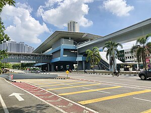
Maluri station
LRT and MRT integrate in Kuala Lumpur, Malaysia
Distance: Approx. 249 meters
Latitude and longitude: 3.12326111,101.72696111
The Maluri station is an integrated light rapid transit (LRT) and mass rapid transit (MRT) located on the eastern fringe of Kuala Lumpur near and named after Taman Maluri (Malay; English: Maluri Garden), a residential housing estate. The station is located along Federal Route 1 Jalan Cheras (English: Cheras Road) opposite the AEON Taman Maluri shopping centre and Sunway Velocity Mall. The Kerayong River also runs beside the station.
Taman Pertama MRT station
MRT station in Kuala Lumpur, Malaysia
Distance: Approx. 1187 meters
Latitude and longitude: 3.11273889,101.72928889
Taman Pertama MRT station is a mass rapid transit (MRT) station on the MRT Kajang Line in Cheras, Kuala Lumpur, Malaysia. It is located along Federal Route 1 Jalan Cheras, which is just right next to where it branches to Jalan Loke Yew, Jalan Yaacob Latif and Jalan Cheras. It was opened on 17 July 2017, along with 18 adjoining stations as part of Phase Two of the MRT SBK line.

Taman Midah MRT station
MRT station in Kuala Lumpur, Malaysia
Distance: Approx. 2130 meters
Latitude and longitude: 3.1045,101.73219444
The Taman Midah MRT station is a mass rapid transit (MRT) station on the MRT Kajang Line, serving the neighbourhood of Taman Midah and the surrounding residential areas in the suburb of Cheras, Kuala Lumpur, Malaysia. It was opened on 17 July 2017. The station is located directly above Federal Route 1 Jalan Cheras near the site of the former Jalan Cheras toll plaza.

Sunway Velocity Mall
Shopping mall in Cheras, Kuala Lumpur, Malaysia
Distance: Approx. 624 meters
Latitude and longitude: 3.12705556,101.72494444
Sunway Velocity Mall is a shopping mall in Cheras, Kuala Lumpur, Malaysia owned by Sunway Group.
Weather in this IP's area
overcast clouds
27 Celsius
27 Celsius
25 Celsius
27 Celsius
1008 hPa
92 %
1008 hPa
1002 hPa
10000 meters
0.8 m/s
1.46 m/s
309 degree
100 %
07:03:52
19:11:29