Country:
 Malaysia
Region:
City:
Latitude and Longitude:
Time Zone:
Postal Code:
IP information under different IP Channel
ip-api
Country
Region
City
ASN
Time Zone
ISP
Blacklist
Proxy
Latitude
Longitude
Postal
Route
IPinfo
Country
Region
City
ASN
Time Zone
ISP
Blacklist
Proxy
Latitude
Longitude
Postal
Route
MaxMind
Country
Region
City
ASN
Time Zone
ISP
Blacklist
Proxy
Latitude
Longitude
Postal
Route
Luminati
Country
MYRegion
14
City
kualalumpur
ASN
Time Zone
Asia/Kuala_Lumpur
ISP
Binariang Berhad
Latitude
Longitude
Postal
db-ip
Country
Region
City
ASN
Time Zone
ISP
Blacklist
Proxy
Latitude
Longitude
Postal
Route
ipdata
Country
Region
City
ASN
Time Zone
ISP
Blacklist
Proxy
Latitude
Longitude
Postal
Route
Popular places and events near this IP address

Malayan Union
Post-war federation of the Malay states and the Straits Settlements of Penang and Malacca
Distance: Approx. 945 meters
Latitude and longitude: 3.13333333,101.7
The Malayan Union (Malay: Kesatuan Malaya;[1] Jawi: كساتوان مالايا) was a union of the Malay states and the Straits Settlements of Penang and Malacca. It was the successor to British Malaya and was conceived to unify the Malay Peninsula under a single government to simplify administration. Following opposition by the ethnic Malays, the union was reorganised as the Federation of Malaya in 1948.
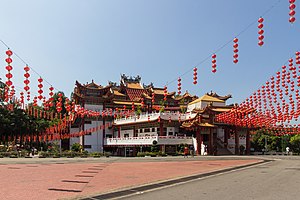
Thean Hou Temple
Chinese temple in Kuala Lumpur, Malaysia
Distance: Approx. 1064 meters
Latitude and longitude: 3.12166667,101.68777778
The Thean Hou Temple (Chinese: 乐圣岭天后宫/樂聖嶺天后宮) is a six-tiered temple of the Chinese sea goddess Mazu located in Kuala Lumpur, Malaysia. It is located on 1.67 acres (6,758 m2) of land atop Robson Heights on Lorong Bellamy, overlooking Jalan Syed Putra. It was completed in 1987 and officially opened in 1989.

Istana Negara, Jalan Istana
Former residence of the Yang di-Pertuan Agong
Distance: Approx. 772 meters
Latitude and longitude: 3.132487,101.695703
The Royal Museum (Malay: Muzium Diraja) along Jalan Istana was the former National Palace (Malay: Istana Negara) and former residence of the Yang di-Pertuan Agong (Supreme King) of Malaysia. It stands on a 13-acre (50,000 m2) site, located on a commanding position on the slope of a hill of Bukit Petaling overlooking the Klang River, along Jalan Syed Putra. It was replaced by the new national palace as the official residence of the king in 2011.

Buddhist Maha Vihara, Brickfields
Theravadin Buddhist temple in Brickfields, Kuala Lumpur, Malaysia
Distance: Approx. 1106 meters
Latitude and longitude: 3.1278875,101.68681306
Buddhist Maha Vihara (Sinhala: මහින්ද්රා බෞද්ධ පන්සල) (also called as the Brickfields Buddhist Temple) is a Sri Lankan temple situated in Brickfields of Kuala Lumpur in Malaysia. The temple became a focal point for the annual Wesak festival within the city suburb.
Bukit Petaling
Distance: Approx. 642 meters
Latitude and longitude: 3.13016667,101.70002778
Bukit Petaling is a location in Kuala Lumpur, Malaysia and is the site of the Istana Negara, or National Palace of Malaysia. Jalan Istana and Jalan Syed Putra are the two major roads servicing this area.

Sri Kandaswamy Kovil, Brickfields
Hindu temple in Kuala Lumpur, Malaysia
Distance: Approx. 969 meters
Latitude and longitude: 3.133694,101.693304
The Sri Kandaswamy Kovil (Malay: Kuil Sri Kandaswamy) is a Hindu temple located along Jalan Scott, Brickfields in Kuala Lumpur, Malaysia. The temple is over a century old. It is one of the most prominent Sri Lankan Tamil or Ceylonese Tamil temples in Malaysia.

Institute of Diplomacy and International Affairs
Affiliated agency of the Ministry of Foreign Affairs of the Republic of China
Distance: Approx. 1131 meters
Latitude and longitude: 3.133471,101.702939
The Institute of Diplomacy and International Affairs (abbreviated IDIA; Chinese: 外交部外交及國際事務學院; pinyin: Wàijiāobù Wàijiāojí Guójì Shìwù Xuéyuàn) is an affiliated agency of the Ministry of Foreign Affairs of the Republic of China (Taiwan). It is responsible for providing professional training to newly recruited and mid-career diplomats and engaging in academic exchanges with other foreign service institutes and policy research institutions. The IDIA is located in Da'an District, Taipei.

Bandar Malaysia
Proposed transit-oriented development in Kuala Lumpur, Malaysia
Distance: Approx. 1067 meters
Latitude and longitude: 3.11958333,101.70397222
Bandar Malaysia was a proposed mixed-use transit-oriented development located in Kuala Lumpur, Malaysia. This project was to be built at the current Sungai Besi Air Base site over 20 years. It was also planned as a central transport hub connecting high-speed rail to Singapore (namely the Kuala Lumpur–Singapore High Speed Rail), Mass Rapid Transit, KTM Komuter, Express Rail Link, and 12 other highways with an estimated gross development value (GDV) of over RM140 billion.
Bandar Malaysia Utara MRT station
Metro station in Kuala Lumpur, Malaysia
Distance: Approx. 1270 meters
Latitude and longitude: 3.11621,101.70299
The Bandar Malaysia Utara MRT station (Working name: Bandar Malaysia North) is a planned Mass Rapid Transit (MRT) underground station on the MRT Putrajaya Line. The station will serve the future development of Bandar Malaysia in Salak Selatan, Kuala Lumpur, Malaysia.

Malaysia Design Archive
Archive in Kuala Lumpur, Malaysia
Distance: Approx. 1367 meters
Latitude and longitude: 3.13786111,101.69713889
The Malaysia Design Archive (MDA) is a non-profit private organization based in Kuala Lumpur oriented towards various projects to document, discuss, and preserve Malaysia's visual culture. Its leading team members are Ezrena Marwan, Jac sm Kee, and Simon Soon. Their core material collection are graphic materials tracing the development of Malaysia from the period before independence (1957) until current times.

Church of the Holy Rosary, Kuala Lumpur
Church in Kuala Lumpur, Malaysia
Distance: Approx. 1290 meters
Latitude and longitude: 3.13665,101.69299
Church of the Holy Rosary is a Catholic church situated at Jalan Tun Sambanthan, Kuala Lumpur, and is considered one of the finest examples of neo-gothic architecture in Malaysia.

Evangelical Lutheran Zion Church, Kuala Lumpur
Church in Kuala Lumpur, Malaysia
Distance: Approx. 1184 meters
Latitude and longitude: 3.12885,101.68636
The Evangelical Lutheran Zion Church is a Protestant Lutheran church situated at Jalan Sultan Abdul Samad, Brickfields, Kuala Lumpur, Malaysia. It was built to serve mainly Tamil labourers from South India many of whom were Lutherans.
Weather in this IP's area
few clouds
27 Celsius
30 Celsius
26 Celsius
28 Celsius
1010 hPa
78 %
1010 hPa
1004 hPa
10000 meters
20 %
06:56:50
18:59:10