Country:
 India
IndiaRegion:
City:
Latitude and Longitude:
Time Zone:
Postal Code:
IP information under different IP Channel
ip-api
Country
Region
City
ASN
Time Zone
ISP
Blacklist
Proxy
Latitude
Longitude
Postal
Route
IPinfo
Country
Region
City
ASN
Time Zone
ISP
Blacklist
Proxy
Latitude
Longitude
Postal
Route
MaxMind
Country
Region
City
ASN
Time Zone
ISP
Blacklist
Proxy
Latitude
Longitude
Postal
Route
Luminati
Country
INRegion
tn
City
karumapuram
ASN
Time Zone
Asia/Kolkata
ISP
National Internet Backbone
Latitude
Longitude
Postal
db-ip
Country
Region
City
ASN
Time Zone
ISP
Blacklist
Proxy
Latitude
Longitude
Postal
Route
ipdata
Country
Region
City
ASN
Time Zone
ISP
Blacklist
Proxy
Latitude
Longitude
Postal
Route
Popular places and events near this IP address
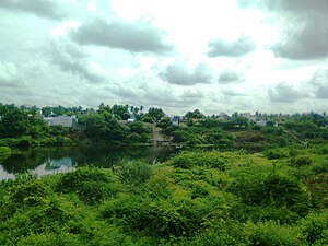
Kolathur, Salem
Town in Tamil Nadu, India
Distance: Approx. 2117 meters
Latitude and longitude: 11.51,77.45
Kolathur is a medium-sized town in Salem district in the Indian state of Tamil Nadu. It is located near Mettur and surrounded by Cavery river.
Kuhalur
Town Panchayat in Tamil Nadu, India
Distance: Approx. 5830 meters
Latitude and longitude: 11.49388889,77.50472222
Kugalur is a panchayat town in Erode district in the Indian state of Tamil Nadu.
Athani, Erode
Town panchayat in Tamil Nadu, India
Distance: Approx. 5474 meters
Latitude and longitude: 11.52305556,77.51194444
Athani is a panchayat town located about 13 km from Gobichettipalayam in Anthiyur taluk of Erode district in the state of Tamil Nadu, India.
Kolathur, Tamil Nadu Assembly constituency
Vidhan Sabha constituency
Distance: Approx. 2117 meters
Latitude and longitude: 11.51,77.45
Kolathur, கொளத்தூர் (புதுக்கோட்டை) (சட்டமன்றத் தொகுதி - 190) was former state assembly constituency in Tamil Nadu. Formed in the year 1977, it was a part of Pudukkottai (Lok Sabha constituency) till the Delimitation of Constituencies, 2008. In 2006 assembly election, it had a total of 1,97,012 voters out of which 97,346 were male and 99,666 were female voters.

Pariyur Kondathu Kaliamman Temple
Temple in Tamil Nadu, India
Distance: Approx. 5335 meters
Latitude and longitude: 11.4775,77.45611111
Kondathu Kaliamman Temple is an Amman temple located at Pariyur near Gobichettipalayam in Tamil Nadu, India. There are other temples, namely Sri Amarapaneeswarar Temple, Sri Adinarayana Perumal Temple and Sri Angalamman Temple nearby.
Pariyur
Panchayat village in India
Distance: Approx. 5335 meters
Latitude and longitude: 11.4775,77.45611111
Pariyur is a panchayat village located near Gobichettipalayam in Erode District of Tamil Nadu state, India. It is located about 3 km from Gobichettipalayam on the way to Anthiyur via Savandapur. It is a religious center with many famous temples including the Pariyur Kondathu Kaliamman temple.
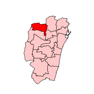
Kolathur Assembly constituency
State Legislative Assembly Constituency in Tamil Nadu
Distance: Approx. 2117 meters
Latitude and longitude: 11.51,77.45
Kolathur State Assembly constituency (Tamil: கொளத்தூர் சட்டமன்றத் தொகுதி) is one of the 234 state legislative assembly constituencies in Tamil Nadu in southern India. Its State Assembly Constituency number is 13. It is also one of the 6 state legislative assembly constituencies included in the Chennai North Lok Sabha constituency.
Kolathur block
Distance: Approx. 2117 meters
Latitude and longitude: 11.51,77.45
Kolathur block is a revenue block of Salem district of the Indian state of Tamil Nadu. This revenue block consist of 14 panchayat villages.

Pudukaraipudur
Town panchayat in Tamil Nadu, India
Distance: Approx. 4873 meters
Latitude and longitude: 11.485,77.47972222
Pudukkaraipudur is a panchayat in Gobichettipalayam taluk in Erode District of Tamil Nadu state, India. It is about 5 km from Gobichettipalayam and 35 km from district headquarters Erode. The village is surrounded by beautiful paddy fields and canals.
Kanakampalayam
Panchayat village in India
Distance: Approx. 1533 meters
Latitude and longitude: 11.52222222,77.44805556
Kanakampalayam is a panchayat village in Gobichettipalayam taluk in Erode District of Tamil Nadu state, India. It is about 10 km from Gobichettipalayam and 47 km from district headquarters Erode. The village is located on the road connecting Gobichettipalayam with Athani, Tamil Nadu.
Kondayampalayam
Panchayat village in India
Distance: Approx. 2917 meters
Latitude and longitude: 11.51694444,77.43638889
Kondayampalayam is a panchayat village in Gobichettipalayam taluk in Erode District of Tamil Nadu state, India. It is about 10 km from Gobichettipalayam and 48 km from district headquarters Erode. The village is located on the road connecting Gobichettipalayam with Athani, Tamil Nadu via Kallipatti.
Perumugai
Panchayat village in India
Distance: Approx. 1720 meters
Latitude and longitude: 11.51805556,77.47583333
Perumugai is a panchayat village in Gobichettipalayam taluk in Erode District of Tamil Nadu state, India. It is about 12 kilometres (7.5 mi) from Gobichettipalayam and 442 kilometres (275 mi) from the district headquarters Erode. The village is located on the road connecting Gobichettipalayam with Athani via Kallipatti.
Weather in this IP's area
clear sky
23 Celsius
23 Celsius
23 Celsius
24 Celsius
1008 hPa
78 %
1008 hPa
985 hPa
10000 meters
0.96 m/s
1.31 m/s
312 degree
5 %
06:09:27
18:18:31