Country:
 India
IndiaRegion:
City:
Latitude and Longitude:
Time Zone:
Postal Code:
IP information under different IP Channel
ip-api
Country
Region
City
ASN
Time Zone
ISP
Blacklist
Proxy
Latitude
Longitude
Postal
Route
IPinfo
Country
Region
City
ASN
Time Zone
ISP
Blacklist
Proxy
Latitude
Longitude
Postal
Route
MaxMind
Country
Region
City
ASN
Time Zone
ISP
Blacklist
Proxy
Latitude
Longitude
Postal
Route
Luminati
Country
INRegion
tn
City
karumapuram
ASN
Time Zone
Asia/Kolkata
ISP
National Internet Backbone
Latitude
Longitude
Postal
db-ip
Country
Region
City
ASN
Time Zone
ISP
Blacklist
Proxy
Latitude
Longitude
Postal
Route
ipdata
Country
Region
City
ASN
Time Zone
ISP
Blacklist
Proxy
Latitude
Longitude
Postal
Route
Popular places and events near this IP address
Tiruchengode
Municipality in Tamil Nadu, India
Distance: Approx. 9328 meters
Latitude and longitude: 11.379,77.8949
Tiruchengode is a selection-grade municipality located in western part of southern Indian state of Tamil Nadu. It is famous for the ancient hilltop Ardhanareeswarar Temple, dedicated to the unique combined male-female form of Lord Shiva and Goddess Parvathi. This important place of pilgrimage is mentioned in the Tamil work Silapathikaram as 'Nedulkundru' and is celebrated in the hymns of Saivite saints.
Tiruchengode Lok Sabha constituency
Defunct parliament constituency in Tamil Nadu, India
Distance: Approx. 9505 meters
Latitude and longitude: 11.38,77.89
Tiruchengode is a former constituency of the Lok Sabha in Tamil Nadu state. After delimitation in 2009, it is now a defunct constituency. The region covered by this constituency is now a part of the Namakkal constituency.

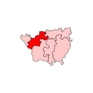
Sangagiri
Town in Tamil Nadu, India
Distance: Approx. 7761 meters
Latitude and longitude: 11.4745,77.8691
Sangagiri is a panchayat town in Salem district in the Indian state of Tamil Nadu. It is situated on the National Highway 544, on the Coimbatore - Salem section. Sangagiri is known for Sangagiri fort, lorries and lorry building industries.
Kumaramangalam
Village in Tamil Nadu, India
Distance: Approx. 9447 meters
Latitude and longitude: 11.367574,77.930017
Kumaramangalam is a village in Namakkal district in Tamil Nadu state in India. Kumaramangalam is an ancient village near Tiruchengodu, located on a busy state highway between Erode and Namakkal. It houses many engineering, Arts and nursing colleges.
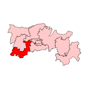
Sangagiri Assembly constituency
State Legislative Assembly Constituency in Tamil Nadu
Distance: Approx. 7521 meters
Latitude and longitude: 11.47,77.87
Sangagiri or 'Sankari' is a state assembly constituency in Salem district, Tamil Nadu, India. Its State Assembly Constituency number is 87. It comprises Sangagiri taluk and a portion of Omalur taluk.
Tiruchengode Assembly constituency
State Legislative Assembly Constituency in Tamil Nadu
Distance: Approx. 9505 meters
Latitude and longitude: 11.38,77.89
Tiruchengode or 'Tiruchengodu' is a state assembly constituency in Namakkal district in Tamil Nadu. Its State Assembly Constituency number is 96. It consists of a portion of Tiruchengodu taluk.
Sangagiri taluk
Distance: Approx. 7887 meters
Latitude and longitude: 11.48,77.87
Sangagiri taluk is a taluk of Salem district of the Indian state of Tamil Nadu. The headquarters of the taluk is the town of Sangagiri.

Mahendra Engineering College
Engineering college in Mallasamudram, Tamil Nadu, India
Distance: Approx. 7465 meters
Latitude and longitude: 11.477815,77.999737
Mahendra Engineering College (Autonomous) is an Engineering College in the Indian state of Tamil Nadu. It teaches engineering subjects for approximately 10,000 students pursuing the Bachelor of Engineering and/or MBAs.
Sangagiri block
Distance: Approx. 7887 meters
Latitude and longitude: 11.48,77.87
Sangagiri block is a revenue block of Salem district of the Indian state of Tamil Nadu. This revenue block consist of 22 panchayat villages. They are: Alathur Devannagoundanur Katheri Koneripatti Morur East Olakkachinnanur Sanyasipatti Agraharam Veerachipalayam Annathanapatti Irugalur Kaveripatti Koneripatti Agrm.
Thangayur
Village in Tamil Nadu, India
Distance: Approx. 9744 meters
Latitude and longitude: 11.52,77.88
Thangayur is a village in the west of Salem District, Tamil Nadu, India.
Sattaiyampudur
Pudur in Tamil Nadu, India
Distance: Approx. 9170 meters
Latitude and longitude: 11.3805,77.895125
Sattaiyampudur (also called Pudur) is a town, on the periphery of Tiruchengode, Namakkal District.
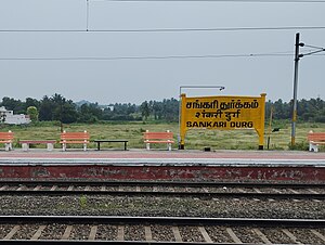
Sankari Durg railway station
Railway station in Tamil Nadu, India
Distance: Approx. 7197 meters
Latitude and longitude: 11.4464,77.8708
Sangagiri Railway Station (officially Sankari Durg railway station)(station code: SGE) is an NSG–5 category Indian railway station in Salem railway division of Southern Railway zone. It located is a station, 3.5 kms south of Sangagiri town of Tamil Nadu, India. It is located between Mavelipalaiyam and Anangur.
Weather in this IP's area
clear sky
23 Celsius
24 Celsius
22 Celsius
23 Celsius
1008 hPa
83 %
1008 hPa
978 hPa
10000 meters
0.67 m/s
1.18 m/s
274 degree
8 %
06:07:33
18:16:36