Country:
 India
IndiaRegion:
City:
Latitude and Longitude:
Time Zone:
Postal Code:
IP information under different IP Channel
ip-api
Country
Region
City
ASN
Time Zone
ISP
Blacklist
Proxy
Latitude
Longitude
Postal
Route
IPinfo
Country
Region
City
ASN
Time Zone
ISP
Blacklist
Proxy
Latitude
Longitude
Postal
Route
MaxMind
Country
Region
City
ASN
Time Zone
ISP
Blacklist
Proxy
Latitude
Longitude
Postal
Route
Luminati
Country
INRegion
tn
City
karumapuram
ASN
Time Zone
Asia/Kolkata
ISP
National Internet Backbone
Latitude
Longitude
Postal
db-ip
Country
Region
City
ASN
Time Zone
ISP
Blacklist
Proxy
Latitude
Longitude
Postal
Route
ipdata
Country
Region
City
ASN
Time Zone
ISP
Blacklist
Proxy
Latitude
Longitude
Postal
Route
Popular places and events near this IP address
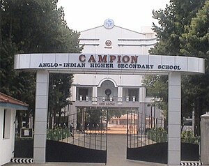
Campion Anglo-Indian Higher Secondary School
Partly-aided secondary school in Tiruchirapalli, India
Distance: Approx. 1077 meters
Latitude and longitude: 10.805475,78.68449
Campion Anglo-Indian Higher Secondary School was started in the year 1934 at Tiruchirapalli, Tamil Nadu, India. The school is named after its patron saint, St. Edmund Campion.
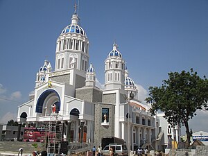
Roman Catholic Diocese of Tiruchirapalli
Roman Catholic diocese in Tamil Nadu, India
Distance: Approx. 615 meters
Latitude and longitude: 10.8047,78.6916
The Roman Catholic Diocese of Tiruchirapalli/Trichy (Latin: Tiruchirapolitan(us)) is a diocese located in the city of Tiruchirapalli in the ecclesiastical province of Madurai in India. The episcopal seat is St. Mary's Cathedral, Tiruchirappalli, also known as the Cathedral of the Mother of Good Health.

Tiruchirappalli Lok Sabha constituency
One of the 39 Parliamentary Constituencies in Tamil Nadu, in India.
Distance: Approx. 1339 meters
Latitude and longitude: 10.8,78.7
Tiruchirappalli is a Lok Sabha (Parliament of India) constituency in Tamil Nadu. Its Tamil Nadu Parliamentary Constituency number is 24 of 39.
Basilica of the Holy Redeemer, Tiruchirappalli
Church in Tamil Nadu, India
Distance: Approx. 526 meters
Latitude and longitude: 10.8103,78.698
The Basilica of the Holy Redeemer, Tiruchirappalli is one of five Roman Catholic minor basilicas in the southern state of Tamil Nadu, India.
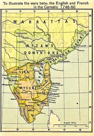
Siege of Trichinopoly (1743)
1743 siege and capture of Trichinopoly by Nizam of Hyderabad
Distance: Approx. 1004 meters
Latitude and longitude: 10.805,78.68555556
The Siege of Trichinopoly (14 March 1743 – 29 August 1743) was part of an extended series of conflicts between the Nizam of Hyderabad and the Maratha Empire for control of the Carnatic region. On 29 August 1743, after a six-month siege, Murari Rao surrendered, giving Nizam ul Mulk (Nizam) the suzerainty of Trichinopoly. By the end of 1743, the Nizam had regained full control of Deccan.
Beema Nagar
Distance: Approx. 332 meters
Latitude and longitude: 10.808736,78.690452
Beema Nagar (Tamil: பீம நகர்) is an area of the city of Tiruchirapalli in the Indian state of Tamil Nadu. The district court and district registrar office are located within the neighborhood.
Gandhi Market
Shopping mall in Tamil Nadu, India
Distance: Approx. 1462 meters
Latitude and longitude: 10.8227047,78.696597
Gandhi Market officially called as Mahatma Gandhi Market, is a wholesale farmers' market in the city of Tiruchirappalli in Tamil Nadu, India.

Tiruchirappalli East Assembly constituency
One of the 234 State Legislative Assembly Constituencies in Tamil Nadu
Distance: Approx. 744 meters
Latitude and longitude: 10.81,78.7
Tiruchirappalli (East) is a constituency of Tamil Nadu Legislative Assembly located in Tiruchirappalli district of Tamil Nadu. Its State Assembly Constituency number is 141. It was called as Tiruchirappalli – II before the constituency delimitations 2008.
Pathalapattai
Village in Tamil Nadu, India
Distance: Approx. 1004 meters
Latitude and longitude: 10.805,78.68555556
Pathalapattai is a village in Tiruchirappalli taluk of Tiruchirappalli district in Tamil Nadu, India.
World War I Memorial (Tiruchirappalli)
World War I Memorial in Tiruchirappalli
Distance: Approx. 722 meters
Latitude and longitude: 10.8155,78.6967
World War I Memorial, located opposite to Gandhi Market, Tiruchirappalli in the state of Tamil Nadu, India, is a war memorial dedicated to the soldiers of Trichinopoly.
Maruti Hospital, Tiruchirappalli
Hospital in Tamil Nadu, India
Distance: Approx. 1425 meters
Latitude and longitude: 10.8099833,78.6801677
Maruti Hospital is a multi-speciality hospital located in Tiruchirappalli, Tamil Nadu, India.
St. Mary's Cathedral, Tiruchirappalli
Church in Tamil Nadu, India
Distance: Approx. 546 meters
Latitude and longitude: 10.805372,78.691547
St. Mary's Cathedral, Tiruchirappalli is a Roman Catholic church situated in Tiruchirappalli district of Tamil Nadu state in the peninsular India. This cathedral is dedicated to St.
Weather in this IP's area
haze
27 Celsius
29 Celsius
27 Celsius
27 Celsius
1007 hPa
74 %
1007 hPa
998 hPa
5000 meters
5.14 m/s
270 degree
20 %
06:04:36
18:13:30