Country:
Region:
City:
Latitude and Longitude:
Time Zone:
Postal Code:
IP information under different IP Channel
ip-api
Country
Region
City
ASN
Time Zone
ISP
Blacklist
Proxy
Latitude
Longitude
Postal
Route
Luminati
Country
Region
tn
City
thanjavur
ASN
Time Zone
Asia/Kolkata
ISP
National Internet Backbone
Latitude
Longitude
Postal
IPinfo
Country
Region
City
ASN
Time Zone
ISP
Blacklist
Proxy
Latitude
Longitude
Postal
Route
db-ip
Country
Region
City
ASN
Time Zone
ISP
Blacklist
Proxy
Latitude
Longitude
Postal
Route
ipdata
Country
Region
City
ASN
Time Zone
ISP
Blacklist
Proxy
Latitude
Longitude
Postal
Route
Popular places and events near this IP address

Thanjavur
Historical city in Tamil Nadu, India
Distance: Approx. 482 meters
Latitude and longitude: 10.787,79.13780556
Thanjavur (Tamil: [t̪aɲdʑaːʋuːɾ]), also known as Thanjai, previously known as Tanjore, is a city in the Indian state of Tamil Nadu. It is the 12th biggest city in Tamil Nadu. Thanjavur is an important center of southern Indian religion, art, and architecture.
Saraswathi Mahal Library
Library located in Thanjavur (Tanjore), Tamil Nadu, India
Distance: Approx. 923 meters
Latitude and longitude: 10.79138889,79.13611111
Saraswathi Mahal Library, also called Thanjavur Maharaja Serfoji's Saraswathi Mahal Library is a library located in Thanjavur (Tanjore), Tamil Nadu, India. It is one of the oldest libraries in Asia established during 16th century by Nayakar kings of Thanjavur and has on display a rare collection of Palm leaf manuscripts and paper written in Tamil and Sanskrit and a few other indigenous languages of india (especially southern regional languages). The collection comprises well over 49,000 volumes, though only a tiny fraction of these are on display.

Great Living Chola Temples
UNESCO World Heritage Site in Tamil Nadu, India
Distance: Approx. 372 meters
Latitude and longitude: 10.78305556,79.1325
The Great Living Chola Temples is a UNESCO World Heritage Site designation for a group of Chola dynasty era Hindu temples in the Indian state of Tamil Nadu. The temple at Thanjavur was added in the list in 1987, while the other two temples were added in 2004.

Thanjavur district
District in Tamil Nadu, India
Distance: Approx. 537 meters
Latitude and longitude: 10.7856,79.1401
Thanjavur district is one of the 38 districts of the state of Tamil Nadu, in southeastern India. Its headquarters is Thanjavur (Tanjore) . The district is located in the delta of the Cauvery River and is mostly agrarian.

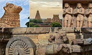
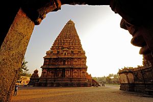
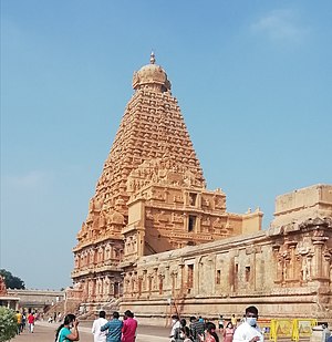
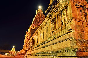
Brihadisvara Temple
11th century temple and UNESCO World Heritage Site
Distance: Approx. 464 meters
Latitude and longitude: 10.78277778,79.13166667
Brihadishvara Temple, called Rajarajesvaram (lit. 'Lord of Rajaraja') by its builder, and known locally as Thanjai Periya Kovil (lit. 'Thanjavur Big Temple') and Peruvudaiyar Kovil, is a Shaivite Hindu temple built in a Chola architectural style located on the south bank of the Cauvery river in Thanjavur, Tamil Nadu, India. It is one of the largest Hindu temples and an exemplar of Tamil architecture. It is also called Dakshina Meru (Meru of the South).
Achampatti
Village in Tamil Nadu, India
Distance: Approx. 697 meters
Latitude and longitude: 10.78481944,79.14202778
Achampatti is a village in the Budhalur taluk of Thanjavur district, Tamil Nadu, India.
Inathukanpatti
Village in Tamil Nadu, India
Distance: Approx. 697 meters
Latitude and longitude: 10.78481944,79.14202778
Inathukanpatti, also known as Inayathukkanpatti, is a village in the Thanjavur taluk of Thanjavur district, Tamil Nadu, India.
Indalur
Metropolitan area in Tamil Nadu, India
Distance: Approx. 697 meters
Latitude and longitude: 10.78481944,79.14202778
Indalur is a village in the Thanjavur taluk of Thanjavur district, Tamil Nadu, India.

Thanjavur Taluk
Distance: Approx. 657 meters
Latitude and longitude: 10.782,79.13
Thanjavur is a taluk of Thanjavur district of the Indian state of Tamil Nadu.

Brihadeeswarar temple fire
Distance: Approx. 464 meters
Latitude and longitude: 10.78277778,79.13166667
Brihadeeswarar temple fire is a fire accident that occurred during the consecration of the Brihadeeswarar Temple on 7 June 1997 in Thanjavur, Tamil Nadu, India. The accident was caused by a spark that caught up the thatch. A stampede occurred due to the panic created, and a total of 48 people were killed and left more than 200 people injured.

Thanjavur Junction railway station
Railway station in Tamil Nadu, India
Distance: Approx. 606 meters
Latitude and longitude: 10.7781,79.1381
Thanjavur Junction (station code: TJ) is an NSG–3 category Indian railway station in Tiruchirappalli railway division of Southern Railway zone. It is a junction railway station in Thanjavur district in the Indian state of Tamil Nadu and serves Thanjavur, earlier known as Tanjore.
Sacred Heart Girls Higher Secondary School
Distance: Approx. 978 meters
Latitude and longitude: 10.7751,79.1396
The Sacred Heart Girls Higher Secondary School in Thanjavur, Tamil Nadu, India, is an educational institute. The administration is under Franciscan Missionaries of Mary. The institution has Kindergarten, Primary school, High School and Higher Secondary.
Weather in this IP's area
overcast clouds
30 Celsius
37 Celsius
29 Celsius
31 Celsius
1008 hPa
82 %
1008 hPa
1001 hPa
10000 meters
4.88 m/s
8.65 m/s
64 degree
100 %
06:06:45
17:47:43
