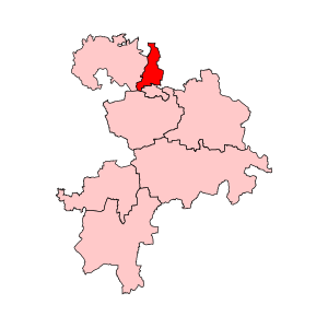
Country:
 India
IndiaRegion:
City:
Latitude and Longitude:
Time Zone:
Postal Code:
IP information under different IP Channel
ip-api
Country
Region
City
ASN
Time Zone
ISP
Blacklist
Proxy
Latitude
Longitude
Postal
Route
IPinfo
Country
Region
City
ASN
Time Zone
ISP
Blacklist
Proxy
Latitude
Longitude
Postal
Route
MaxMind
Country
Region
City
ASN
Time Zone
ISP
Blacklist
Proxy
Latitude
Longitude
Postal
Route
Luminati
Country
INRegion
tn
City
karaikudi
ASN
Time Zone
Asia/Kolkata
ISP
National Internet Backbone
Latitude
Longitude
Postal
db-ip
Country
Region
City
ASN
Time Zone
ISP
Blacklist
Proxy
Latitude
Longitude
Postal
Route
ipdata
Country
Region
City
ASN
Time Zone
ISP
Blacklist
Proxy
Latitude
Longitude
Postal
Route
Popular places and events near this IP address

Thirumuruganpoondi
Town in Tamil Nadu, India
Distance: Approx. 5057 meters
Latitude and longitude: 11.1788,77.3145
Thirumuruganpoondi is a Municipality in Tirupur District in the Indian state of Tamil Nadu. It is about 7 kilometres (4 mi) South from Tirupur city and 38 kilometres (24 mi) west from Coimbatore city.
Andipalayam (Tirupur)
Town in Tamil Nadu, India
Distance: Approx. 5857 meters
Latitude and longitude: 11.09972222,77.31083333
Andipalayam is a census town in Tirupur district in the state of Tamil Nadu, India.
Muruganpalayam
Town in Tamil Nadu, India
Distance: Approx. 5084 meters
Latitude and longitude: 11.09888889,77.32805556
Muruganpalayam is a census town in Tiruppur district in the Indian state of Tamil Nadu.
Neripperichal
Town in Tamil Nadu, India
Distance: Approx. 4414 meters
Latitude and longitude: 11.16666667,77.37416667
Neripperichal is a census town in Tirupur district in the Indian state of Tamil Nadu.
Thottipalayam
Census town in Tamil Nadu, India
Distance: Approx. 2554 meters
Latitude and longitude: 11.1475,77.365
Thottipalayam is a suburb Tiruppur in the Indian state of Tamil Nadu.
Velampalayam
Town in Tamil Nadu, India
Distance: Approx. 4197 meters
Latitude and longitude: 11.14527778,77.30388889
Velampalayam is a third grade municipality in Tiruppur district in the Indian state of Tamil Nadu. As of 2011, the town had a population of 87,427.
Tiruppur Assembly constituency
Former constituency in Tamil Nadu, India
Distance: Approx. 4097 meters
Latitude and longitude: 11.11,77.36
Tiruppur is the legislative assembly, that includes the city, Tiruppur. Tiruppur assembly constituency was part of Coimbatore parliamentary constituency. It was a two-member constituency in 1952 election.
Tiruppur North Assembly constituency
One of the 234 State Legislative Assembly Constituencies in Tamil Nadu, in India
Distance: Approx. 1246 meters
Latitude and longitude: 11.146,77.353
Tiruppur North or 'Tiruppur (North)' is a state assembly constituency in Tiruppur district in Tamil Nadu, India newly formed after constituency delimitations 2008. Its State Assembly Constituency number is 113. It is included in the Tiruppur parliamentary constituency.
Anupparpalayam
Distance: Approx. 2684 meters
Latitude and longitude: 11.143024,77.317631
Anupparpalayam is a small town located within Tirupur Corporation limits. Also called the "metal town of the Kongu region". It is another business zone in Tiruppur district is located 42 km distance to east from Coimbatore city and 7 km north from Tirupur Bus stand.
Tiruppur railway station
Railway station in Tamil Nadu, India
Distance: Approx. 3772 meters
Latitude and longitude: 11.1086,77.3397
Tiruppur railway station (station code: TUP) is an NSG–3 category Indian railway station in Salem railway division of Southern Railway zone. It is a railway station serving the city of Tiruppur.
Thirumuruganatheeswar Temple
Hindu temple in Tamil Nadu, India
Distance: Approx. 4202 meters
Latitude and longitude: 11.165,77.31138889
Thirumuruganatheeswarar Temple (also called Thirumuruganpoondi temple) in Thirumuruganpoondi, a panchayat town in Tiruppur district in the South Indian state of Tamil Nadu, is dedicated to the Hindu god Shiva. Constructed in the Dravidian style of architecture, the present structure of the temple is believed to have been built during the Kongu Cholas period in the 10th century. Shiva is worshipped as Thirumuruganatheeswarar and his consort Parvathi as Avudainayagi.
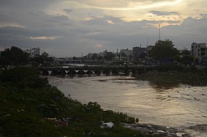
Tiruppur
City in Tamil Nadu, India
Distance: Approx. 3776 meters
Latitude and longitude: 11.1085,77.3411
Tiruppur or Tirupur ([t̪ɪɾɨppuːr] ), is a city in the Indian state of Tamil Nadu. It is located on the banks of the Noyyal river and is the fourth largest urban agglomeration in Tamil Nadu. It is the administrative capital of Tiruppur district and is administered by the Tiruppur Municipal Corporation which was established in 2008.
Weather in this IP's area
few clouds
24 Celsius
24 Celsius
24 Celsius
24 Celsius
1008 hPa
85 %
1008 hPa
974 hPa
10000 meters
4.37 m/s
7.23 m/s
246 degree
15 %
06:09:58
18:18:57