Country:
 India
IndiaRegion:
City:
Latitude and Longitude:
Time Zone:
Postal Code:
IP information under different IP Channel
ip-api
Country
Region
City
ASN
Time Zone
ISP
Blacklist
Proxy
Latitude
Longitude
Postal
Route
IPinfo
Country
Region
City
ASN
Time Zone
ISP
Blacklist
Proxy
Latitude
Longitude
Postal
Route
MaxMind
Country
Region
City
ASN
Time Zone
ISP
Blacklist
Proxy
Latitude
Longitude
Postal
Route
Luminati
Country
INRegion
tn
City
chennai
ASN
Time Zone
Asia/Kolkata
ISP
National Internet Backbone
Latitude
Longitude
Postal
db-ip
Country
Region
City
ASN
Time Zone
ISP
Blacklist
Proxy
Latitude
Longitude
Postal
Route
ipdata
Country
Region
City
ASN
Time Zone
ISP
Blacklist
Proxy
Latitude
Longitude
Postal
Route
Popular places and events near this IP address
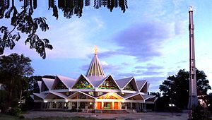
Vellore
City in Tamil Nadu, India
Distance: Approx. 461 meters
Latitude and longitude: 12.9165,79.1325
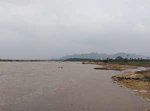
Vellore (English: VAY-loor), also natively spelt as Velur, is a sprawling city and the administrative headquarters of Vellore district in the Indian state of Tamil Nadu. It is located on the banks of the Palar River in the northeastern part of Tamil Nadu and is separated into four zones that are further subdivided into 60 wards, covering an area of 87.915 km2 and housing a population of 423,425 as reported by the 2001 census. It is located about 137.20 kilometres (85 mi) west of Chennai, and about 213.20 kilometres (132 mi) east of Bangalore.

Christian Medical College Vellore
Medical institutions in and around Vellore, Tamil Nadu
Distance: Approx. 780 meters
Latitude and longitude: 12.924815,79.136013
Christian Medical College, Vellore, widely known as CMC, Vellore, is a private, Christian minority community-run medical college and hospital in Vellore, Tamil Nadu, India. This institute includes a network of primary, secondary and tertiary care hospitals. The institute, constituent college is affiliated with the Tamil Nadu Dr.
Vellore district
District of Tamil Nadu in India
Distance: Approx. 1175 meters
Latitude and longitude: 12.91111111,79.13611111
Vellore district (Tamil: [ʋeːluːɾ]) is one of the 38 districts in the Tamil Nadu state of India. It is one of the eleven districts that form the north region of Tamil Nadu. Vellore city is the headquarters of this district.
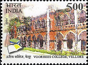
Voorhees College, Vellore
Distance: Approx. 1092 meters
Latitude and longitude: 12.91048611,79.13199722
Voorhees College is a college in Vellore, Tamil Nadu, India. It was founded in 1898 as Arcot Mission College, when Arcot Mission High School was amalgamated to the University of Madras. The college is named after its benefactors, Mr.
Thorapadi, Vellore
Neighbourhood in Vellore District, Tamil Nadu, India
Distance: Approx. 1093 meters
Latitude and longitude: 12.93,79.13
Thorapadi is a part of Vellore Corporation. It is a prominent area in the city of Vellore. Thorapadi is well known for its Vellore Central Prison, Academy of Prisons and Correctional Administration (APCA), Warder's Training Institute, Women's Jail, Christian Medical College (ranked one of the two best Medical Colleges of India by India Today), Parade Grounds and Thanthai Periyar Govt.

Vellore Fort
16th-century fort in India
Distance: Approx. 256 meters
Latitude and longitude: 12.9208333,79.1283333
Vellore Fort is a large 16th-century fort situated in heart of the Vellore city, in the state of Tamil Nadu, India built by the Emperors of Vijayanagara. The fort was at one time the imperial capital of the Aravidu Dynasty of the Vijayanagara Empire. The fort is known for its grand ramparts, wide moat and robust masonry.

Vellore Lok Sabha constituency
One of the 39 Parliamentary Constituencies in Tamil Nadu, India.
Distance: Approx. 294 meters
Latitude and longitude: 12.920219,79.133306
Vellore Lok Sabha constituency is one of the 39 Lok Sabha (parliamentary) constituencies in the present state of Tamil Nadu in Southern India. Its Tamil Nadu Parliamentary Constituency number is 8. The 2019 lok sabha election was scheduled to be held on 18 April in this constituency but the President of India rescinded polling on 16 April after Election Commission of India sent a report stating recovery of huge amount of unaccounted cash allegedly from Dravida Munnetra Kazhagam candidate's office.

Vellore Assembly constituency
State Legislative Assembly Constituency in Tamil Nadu
Distance: Approx. 294 meters
Latitude and longitude: 12.920219,79.133306
Vellore is a legislative assembly constituency in the Indian state of Tamil Nadu. Its State Assembly Constituency number is 43. It includes the city of Vellore and forms a part of the Vellore Lok Sabha constituency for national elections to the Parliament of India.
Ponnam Mangalam
Village in Tamil Nadu, India
Distance: Approx. 516 meters
Latitude and longitude: 12.921349,79.135208
Ponnammangalam is a village that is located in the administrative division of Arcot taluk in Vellore district of the Indian state of Tamil Nadu.
Mettukulam
Distance: Approx. 294 meters
Latitude and longitude: 12.920219,79.133306
Mettukulam Village is situated in the fort city of Vellore, India. The village lies between Vellore (10 km) and Chitoor (26 km) and the temple towns of Thiruvannamalai and Tirupati. Nearby are several colleges, ancient temples and the Christian Medical College and Hospital.
St. John's Church, Vellore
Church in Vellore Fort
Distance: Approx. 278 meters
Latitude and longitude: 12.9201289,79.1280345
St. John’s Church is located inside the Vellore Fort, Tamil Nadu State, India. The Church was raised in 1846 by the Government of Madras for the officers and men of the East India Company military station.

Jalakandeswarar Temple, Vellore
Shiva temple in Vellore, India
Distance: Approx. 295 meters
Latitude and longitude: 12.9206477,79.1279232
Jalakandeswarar Temple is a temple dedicated to Lord Shiva which is located in the Vellore Fort, in heart of the Vellore city, in the state of Tamil Nadu, India.
Weather in this IP's area
clear sky
24 Celsius
25 Celsius
24 Celsius
24 Celsius
1007 hPa
67 %
1007 hPa
983 hPa
10000 meters
2.26 m/s
2.58 m/s
285 degree
8 %
06:02:37
18:12:00