Country:
Region:
City:
Latitude and Longitude:
Time Zone:
Postal Code:
IP information under different IP Channel
ip-api
Country
Region
City
ASN
Time Zone
ISP
Blacklist
Proxy
Latitude
Longitude
Postal
Route
Luminati
Country
Region
tn
City
chennai
ASN
Time Zone
Asia/Kolkata
ISP
National Internet Backbone
Latitude
Longitude
Postal
IPinfo
Country
Region
City
ASN
Time Zone
ISP
Blacklist
Proxy
Latitude
Longitude
Postal
Route
db-ip
Country
Region
City
ASN
Time Zone
ISP
Blacklist
Proxy
Latitude
Longitude
Postal
Route
ipdata
Country
Region
City
ASN
Time Zone
ISP
Blacklist
Proxy
Latitude
Longitude
Postal
Route
Popular places and events near this IP address

Arunachalesvara Temple
Hindu temple in Tiruvannamalai, Tamil Nadu, India
Distance: Approx. 1012 meters
Latitude and longitude: 12.2316,79.0672
Arunachalesvara Temple (also called Annamalaiyar Temple), is a Hindu temple dedicated to the god Shiva and goddess Parvati. located at the base of Arunachala hill in the town of Tiruvannamalai in Tamil Nadu, India. It is significant to the Hindu sect of Shaivism as one of the temples associated with the five elements, the Pancha Bhuta Sthalas, and specifically the element of fire, or Agni.

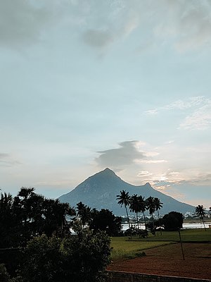
Arunachala
Hill and holy site in Tamil Nadu, India
Distance: Approx. 2452 meters
Latitude and longitude: 12.24111111,79.05722222
Arunachala (IAST: Aruṇācalam [əɾʊˈɳaːtʃələ], 'Red Mountain') is a hill in Tiruvannamalai district, Tamil Nadu, and one of the five main Shaiva holy places in South India. The Arunachalesvara Temple to Shiva is located at the base of the hill. The hill is also known by the names Annamalai, Arunagiri, Arunachalam, Arunai, Sonagiri, and Sonachalam.
SKP Engineering College
College in Tamil Nadu, India
Distance: Approx. 323 meters
Latitude and longitude: 12.22,79.07
SKP Engineering College (SKPEC) is an engineering college in Chinnakangiyanur, Tiruvannamalai, Tamil Nadu, India, founded in 1999 with the aim of providing a technical education to rural citizens in and around Tiruvannamalai. S.K.P Engineering College is a self-financing college, sponsored by Sri. S. Kuppusaamy Memorial Educational Trust.
Vengikkal
Thiruvannamalai Metro in Tamil Nadu, India
Distance: Approx. 2549 meters
Latitude and longitude: 12.2,79.07
Vengikkal is the Suburb of Tiruvannamalai city and a census town in the Tiruvannamalai district of Tamil Nadu state of Indian sub-continent. It lies north to the world famous Tiruvannamalai city. The Divisional and District Government offices of Tiruvannamalai including Tiruvannamalai district collectorate, Tiruvannamalai Transport division headquarters of TNSTC and Tirvannamalai Medical college, government hospital are present in Vengikkal municipal limits.
Adi Annamalai
Suburb in Tiruvannamalai, Tamil Nadu, India
Distance: Approx. 2767 meters
Latitude and longitude: 12.2,79.06
Adhi Annamalai is a suburb of Thiruvannaamalai and selection grade town Panchayat in Thiruvannamalai Taluk.
Athiyandal, Tiruvannamalai
Athiyandal panchayat in Tamil Nadu, India
Distance: Approx. 2883 meters
Latitude and longitude: 12.24,79.05
Athiyandal is a village in Tiruvannamalai taluk, Tiruvannamalai district, Tamil Nadu State. Athiyandal is 0.6 kilometres (0.37 mi) from its district main city, Tiruvannamalai. It is 157 kilometres (98 mi) from its stat main city, Chennai.

Arahanthgiri Jain Math
Distance: Approx. 323 meters
Latitude and longitude: 12.22,79.07
Arahanthgiri Jain Math is a Jain Matha established near Tirumalai in August 1998. The Math is headed by Bhattaraka Dhavalakeerthi.

Government Tiruvannamalai Medical College and Hospital
Hospital in Tamil Nadu, India
Distance: Approx. 539 meters
Latitude and longitude: 12.225987,79.066088
Government Tiruvannamalai Medical College and Hospital (GTMCH) (அரசினர் திருவண்ணாமலை மருத்துவ கல்லூரி மற்றும் மருத்துவமனை) is a medical college operated by the Government of Tamil Nadu, India. It is situated in Thiruvannamalai Outer Ring Road in Vengikkal New town at Thirinjapuram Union, Thiruvannamalai District, Tamil Nadu. The college emerged from the 1 April 2012 transfer of the 440-bed Tiruvannamalai Government District Headquarters Hospital (which had started as a government Taluk hospital in 1950) to the Department of Medical Education who then relaunched it as a teaching hospital offering 100 undergraduate places, the first of whom commenced studies in the 2013-2014 year.
Government Arts College, Thiruvannamalai
Distance: Approx. 1884 meters
Latitude and longitude: 12.222924,79.052585
Government Arts College, Thiruvannamalai, is a general degree college located in Thiruvannamalai, Tamil Nadu. It was established in 1966. It is affiliated with Thiruvalluvar University.
Pancharai Gram Panchayat
Village Panchayat in Tamil Nadu, India
Distance: Approx. 1670 meters
Latitude and longitude: 12.23544,79.07832
Pancharai Village Panchayat (Pancharai Gram Panchayat), It is located in Tellar district in Thiruvannamalai district of Tamil Nadu. This panchayat falls under Vandavasi Assembly Constituency and Arani Lok Sabha Constituency. This panchayat has a total of 7 panchayat constituencies.
Poosimalaikuppam Gram Panchayat
Village Panchayat in Tamil Nadu, India
Distance: Approx. 1670 meters
Latitude and longitude: 12.23544,79.07832
Poosimalaikuppam Village Panchayat (Poosimalaikuppam Gram Panchayat), is a panchayat located in Arani district in Tiruvannamalai district of Tamil Nadu. The panchayat falls under Arani Assembly Constituency and Arani Lok Sabha Constituency. The panchayat has a total of 7 panchayat constituencies.
Kallayee Gram Panchayat
Village Panchayat in Tamil Nadu, India
Distance: Approx. 1670 meters
Latitude and longitude: 12.23544,79.07832
Kallayee Village Panchayat (Kallayee Gram Panchayat), It is located in Kilipennathur locality in Tiruvannamalai district of Tamil Nadu. This panchayat falls under Kilibennathur Assembly Constituency and Thiruvannamalai Lok Sabha Constituency. This panchayat has a total of 7 panchayat constituencies.
Weather in this IP's area
broken clouds
31 Celsius
32 Celsius
31 Celsius
31 Celsius
1009 hPa
46 %
1009 hPa
989 hPa
10000 meters
4.79 m/s
5.25 m/s
37 degree
52 %
06:08:47
17:46:13
