Country:
 The Philippines
Region:
City:
Latitude and Longitude:
Time Zone:
Postal Code:
IP information under different IP Channel
ip-api
Country
Region
City
ASN
Time Zone
ISP
Blacklist
Proxy
Latitude
Longitude
Postal
Route
IPinfo
Country
Region
City
ASN
Time Zone
ISP
Blacklist
Proxy
Latitude
Longitude
Postal
Route
MaxMind
Country
Region
City
ASN
Time Zone
ISP
Blacklist
Proxy
Latitude
Longitude
Postal
Route
Luminati
Country
PHRegion
03
City
angelescity
ASN
Time Zone
Asia/Manila
ISP
Converge ICT Solutions Inc.
Latitude
Longitude
Postal
db-ip
Country
Region
City
ASN
Time Zone
ISP
Blacklist
Proxy
Latitude
Longitude
Postal
Route
ipdata
Country
Region
City
ASN
Time Zone
ISP
Blacklist
Proxy
Latitude
Longitude
Postal
Route
Popular places and events near this IP address
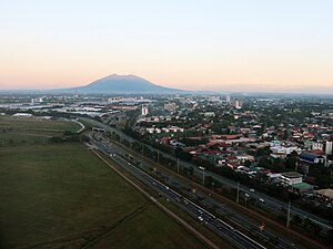
Angeles City
Highly urbanized city in Pampanga, Philippines
Distance: Approx. 573 meters
Latitude and longitude: 15.147181,120.584733
Angeles (locally [ˈaŋhɛlɛs]), officially the City of Angeles (Kapampangan: Lakanbalen ning Angeles; Filipino: Lungsod ng Angeles), is a 1st class highly urbanized city in the Central Luzon region of the Philippines. According to the 2020 census, it has a population of 462,928 people. While Angeles City is politically independent from the province of Pampanga, it is usually grouped with it for statistical purposes by the Philippine Statistics Authority and also it is the largest city of that province.

Balibago
Barangay in Angeles City, Philippines
Distance: Approx. 1880 meters
Latitude and longitude: 15.1687,120.5895
Balibago is a barangay of Angeles City, Philippines. It is located around 50 miles north of the nation's capital, Manila. Within its border to the former U.S. Clark Air Base.
Systems Plus College Foundation
Private college in Angeles, Philippines
Distance: Approx. 1054 meters
Latitude and longitude: 15.15821,120.59379
Systems Plus College Foundation (SPCF) is a private, non-Sectarian basic and higher education institution in Angeles, Pampanga, Philippines.

Angeles City Science High School
Public high school in Angeles, Philippines
Distance: Approx. 1075 meters
Latitude and longitude: 15.145002,120.593077
The Angeles City Science High School (Filipino: Mataas na Paaralang Pang-Agham ng Lungsod ng Angeles) is a Secondary Public Science High School system located on Doña Aurora St., Lourdes Sur East, Angeles City, Philippines. It was founded in 2006. It is a DepEd-recognized science high school.

SM City Clark
Shopping mall in Angeles, Philippines
Distance: Approx. 1935 meters
Latitude and longitude: 15.16845,120.58018
SM City Clark is a large shopping mall owned and operated by SM Prime Holdings, Inc. It is located along M.A. Roxas Highway in Clark Freeport, Angeles City, Philippines. It is the second SM supermall in the province of Pampanga after SM City Pampanga in City of San Fernando and Mexico, Pampanga.
Angeles University Foundation
Roman Catholic university in Angeles, Philippines
Distance: Approx. 1308 meters
Latitude and longitude: 15.145,120.596
The Angeles University Foundation (Filipino: Pundasyong Pamantasan ng Angeles) also referred to by its acronym AUF, is a private Roman Catholic non-stock, non-profit educational institution run by lay persons in Angeles City. It was established on May 25, 1962, by Agustin P. Angeles, Barbara Yap-Angeles, and their family. The university was granted autonomous status and certified with the Institutional Quality Assurance Monitoring and Evaluation (IQuAME) by the Commission of Higher Education.

Apung Mamacalulu
Distance: Approx. 1266 meters
Latitude and longitude: 15.14130556,120.59
Apung Mamacalulu (Merciful Lord, Our Lord of Great Mercy) or the Santo Entierro (Holy Burial) of Angeles City, is a statue depicting the burial of Jesus Christ and is enshrined at the Archdiocesan Shrine of Christ our Lord of the Holy Sepulchre in Lourdes Sur, Angeles City in the Philippines. Thousands flock to hear the special Holy Mass celebrated every Friday at the shrine. Apu, as the lying statue of Jesus is fondly called by devotees, has become a symbol of hope for people longing for a connection to the divine especially when all else failed.

Holy Rosary Parish Church (Angeles City)
Roman Catholic church in Angeles, Philippines
Distance: Approx. 2030 meters
Latitude and longitude: 15.134274,120.590265
Holy Rosary Parish Church, also known as Santo Rosario Church or the Pisamban Maragul (transl. Big Church), is a Roman Catholic church in Angeles City in the Philippines. It is under the jurisdiction of the Archdiocese of San Fernando. The church stands in the epicenter of the old Angeles town (formerly Barrio Culiat of San Fernando, Pampanga), now known as Angeles City.

Bayanihan Park
Distance: Approx. 1821 meters
Latitude and longitude: 15.168459,120.586597
Bayanihan Park is a park in Clark Freeport Zone, Angeles City, Philippines.
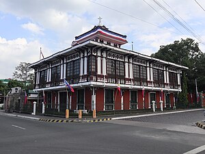
Pamintuan Mansion
Mansion and museum in Angeles, Philippines
Distance: Approx. 1908 meters
Latitude and longitude: 15.13571,120.59151
The Pamintuan Mansion is a historic building in Angeles City, Philippines built by the Pamintuan family in the 1880s. It was briefly used by the Katipunan during the Philippine-American War. It currently hosts a social science museum.

Museo ning Angeles
Museum in Angeles City, Philippines
Distance: Approx. 1992 meters
Latitude and longitude: 15.13479,120.59101
The Museo ning Angeles (Kapampangan for "Museum of Angeles") is a museum in Angeles City, Philippines. It is run by the Kuliat Foundation.

AUF Sports and Cultural Center
University gymnasium in Angeles, Philippines
Distance: Approx. 1284 meters
Latitude and longitude: 15.14436111,120.59516667
The AUF Sports and Cultural Center (AUF–SCC), also known as the AUF Gymnasium, is an indoor arena in Angeles, Philippines. Owned by the Angeles University Foundation, the venue has served various regional and international sports competitions.
Weather in this IP's area
scattered clouds
31 Celsius
38 Celsius
31 Celsius
31 Celsius
1009 hPa
70 %
1009 hPa
998 hPa
10000 meters
2.06 m/s
180 degree
40 %
05:48:02
17:42:05