12.7.31.211 - IP Lookup: Free IP Address Lookup, Postal Code Lookup, IP Location Lookup, IP ASN, Public IP
Country:
Region:
City:
Location:
Time Zone:
Postal Code:
ISP:
ASN:
language:
User-Agent:
Proxy IP:
Blacklist:
IP information under different IP Channel
ip-api
Country
Region
City
ASN
Time Zone
ISP
Blacklist
Proxy
Latitude
Longitude
Postal
Route
db-ip
Country
Region
City
ASN
Time Zone
ISP
Blacklist
Proxy
Latitude
Longitude
Postal
Route
IPinfo
Country
Region
City
ASN
Time Zone
ISP
Blacklist
Proxy
Latitude
Longitude
Postal
Route
IP2Location
12.7.31.211Country
Region
georgia
City
atlanta
Time Zone
America/New_York
ISP
Language
User-Agent
Latitude
Longitude
Postal
ipdata
Country
Region
City
ASN
Time Zone
ISP
Blacklist
Proxy
Latitude
Longitude
Postal
Route
Popular places and events near this IP address

Gresham Park, Georgia
Place in Georgia, United States
Distance: Approx. 2242 meters
Latitude and longitude: 33.70333333,-84.31444444
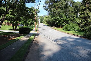
Gresham Park is an unincorporated community and census-designated place (CDP) in DeKalb County, Georgia, United States. The population was 7,700 at the 2020 census.
East Atlanta
Distance: Approx. 2767 meters
Latitude and longitude: 33.74001,-84.34546
East Atlanta is a neighborhood on the east side of Atlanta, Georgia, United States. The name East Atlanta Village primarily refers to the neighborhood's commercial district.
Burns Club Atlanta
Association which celebrates Robert Burns and Scottish literature
Distance: Approx. 2772 meters
Latitude and longitude: 33.72691667,-84.35551667
The Burns Club of Atlanta, officially organized in 1896, is a private social club and literary and cultural society commemorating the works and spirit of the 18th century national poet of Scotland, Robert Burns. In addition to holding monthly meetings, the club has held a Burns supper celebration on the anniversary of Burns' birthday every year since 1898. Club events are held in the Atlanta Burns Cottage, a 1911 replica of poet Robert Burns' birthplace in Alloway, Ayrshire, Scotland.
WJZA (AM)
Radio station in Hapeville, Georgia
Distance: Approx. 955 meters
Latitude and longitude: 33.72861111,-84.32222222
WJZA (1100 kHz) is a commercial AM radio station licensed to Hapeville, Georgia and serving the Atlanta metropolitan area. Owned by Greg Davis, through licensee Davis Broadcasting of Atlanta, LLC, the station airs an urban adult contemporary/talk/sports radio format, with some hours of the broadcast day being paid brokered programming. WJZA is considered as a Class D station according to the Federal Communications Commission.
Burns Cottage (Atlanta)
United States historic place
Distance: Approx. 2776 meters
Latitude and longitude: 33.72694444,-84.35555556
The Burns Cottage in Atlanta, Georgia (USA), is a replica of the birthplace of Robert Burns in Scotland. The Atlanta cottage was built by the Burns Club Atlanta in 1911, using measurements of the original cottage. The interior was adapted for club use, with a meeting room replacing the barn and byre.
East Lake Commons Conservation Community
Distance: Approx. 2476 meters
Latitude and longitude: 33.73694444,-84.30811111
The East Lake Commons Conservation Community in Atlanta, Georgia is a residential project which is award-winning for its sustainable design. It was awarded the World Habitat Award by the United Nations in 2001. Designers of the project include architects Charles Durrett and Kathryn McCamant.

The EARL
Distance: Approx. 2884 meters
Latitude and longitude: 33.741,-84.346
The EARL is an alternative music venue in Atlanta, Georgia, located on Flat Shoals Avenue in the neighborhood of East Atlanta.

Alonzo A. Crim Open Campus High School
Public school in Atlanta, Georgia , United States
Distance: Approx. 2769 meters
Latitude and longitude: 33.74540556,-84.33089722
Alonzo A. Crim Open Campus High School (COCHS) was a public high school in Atlanta, Georgia, United States that closed in 2020. It replaced Alonzo A. Crim Comprehensive High School after it closed in 2005. Part of Atlanta Public Schools, it is located at 256 Clifton Street SE in southeast Atlanta, in the Kirkwood neighborhood.

McNair High School (Georgia)
Public school in DeKalb County, Georgia, United States
Distance: Approx. 1727 meters
Latitude and longitude: 33.7053,-84.3258
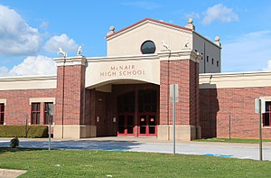
Ronald E. McNair High School is a public school in unincorporated DeKalb County, Georgia, United States, located at 1804 Bouldercrest Road SE, Atlanta, GA 30316. It is in the Gresham Park census-designated place, southeast of Atlanta. The school was originally named Walker High School, but was renamed to McNair High School in 1987 .
Charlie Yates Golf Course
Golf course in Atlanta, Georgia, U.S.
Distance: Approx. 2667 meters
Latitude and longitude: 33.743005,-84.315685
In 1998 East Lake Golf Club's No. 2 golf course was transformed into the Charlie Yates Golf Course, a 9-hole "executive" public course that also provides golf education to children living in the city of Atlanta. The course was rated one of the top 10 short range courses in America by Golf Range Magazine and all profits from the course go to benefit the East Lake Foundation.
Madison Theatre (Atlanta)
Distance: Approx. 2834 meters
Latitude and longitude: 33.7407,-84.3456
Madison Theater is a historic 1927 theater building in East Atlanta, Georgia. It was designed by Daniell & Beutell in a Moorish Revival architecture style and opened with 600 seats. It is at 496 Flat Shoals Avenue.

Old Atlanta Prison Farm
Abandoned prison complex in Atlanta, Georgia
Distance: Approx. 2740 meters
Latitude and longitude: 33.69722222,-84.335
The Old Atlanta Prison Farm is an abandoned, city-owned prison complex in southwest DeKalb County in the U.S. state of Georgia. From approximately 1920 to 1990, the farm was worked by prisoners to produce food for the region's prison system. There are limited historical records detailing the operation of the farm, especially after 1965.
Weather in this IP's area
clear sky
1 Celsius
1 Celsius
-0 Celsius
3 Celsius
1031 hPa
48 %
1031 hPa
996 hPa
10000 meters
