Country:
Region:
City:
Latitude and Longitude:
Time Zone:
Postal Code:
IP information under different IP Channel
ip-api
Country
Region
City
ASN
Time Zone
ISP
Blacklist
Proxy
Latitude
Longitude
Postal
Route
Luminati
Country
Region
il
City
decatur
ASN
Time Zone
America/Chicago
ISP
INS-AS
Latitude
Longitude
Postal
IPinfo
Country
Region
City
ASN
Time Zone
ISP
Blacklist
Proxy
Latitude
Longitude
Postal
Route
db-ip
Country
Region
City
ASN
Time Zone
ISP
Blacklist
Proxy
Latitude
Longitude
Postal
Route
ipdata
Country
Region
City
ASN
Time Zone
ISP
Blacklist
Proxy
Latitude
Longitude
Postal
Route
Popular places and events near this IP address
Macon County, Illinois
County in Illinois, United States
Distance: Approx. 2101 meters
Latitude and longitude: 39.86,-88.96
Macon County is a county located in the U.S. state of Illinois. According to the 2020 United States Census, it had a population of 103,998. Its county seat and most populous city is Decatur.

Staley Field
Sporting venue in the United States
Distance: Approx. 1836 meters
Latitude and longitude: 39.84666667,-88.92638889
Staley Field in Decatur, Illinois, United States, was the home of the Decatur Staleys club of the American Professional Football Association in 1920, coached and managed by the young George Halas, who also played for the team. The team was owned by the A. E. Staley Manufacturing Company, for which Staley Field was the company athletic field. Staley Field was also used by the company baseball team during the summer months, and Halas also played on that team.

Area codes 217 and 447
Area codes in west and central Illinois, United States
Distance: Approx. 1361 meters
Latitude and longitude: 39.8666667,-88.95
Area codes 217 and 447 are telephone area codes in the North American Numbering Plan (NANP) for much of the central part of the U.S. state of Illinois. The numbering plan area (NPA) includes the state capital, Springfield, and Champaign, Urbana, Decatur, Taylorville, Lincoln, Danville, Effingham, Quincy, Rantoul, and Jacksonville. 217 was one of the original North American area codes created in 1947 and 447 was added to the same area in 2021 to form an all-services overlay.

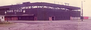
Fans Field (Decatur)
Former minor league baseball park in Decatur, IL, USA
Distance: Approx. 35 meters
Latitude and longitude: 39.861518,-88.935893
Fans Field was a minor league baseball park in Decatur, IL. It was the home of the Decatur Commodores, of the Three-I League, Mississippi-Ohio Valley League and Midwest League, from 1927 through 1974. It was at the southeast corner of East Garfield Avenue (left field) and North Woodford Street (third base). During late 1974 and early 1975, the city debated what to do with the abandoned ballpark.

St. Teresa High School (Decatur, Illinois)
Private school in Decatur, Illinois, United States
Distance: Approx. 1985 meters
Latitude and longitude: 39.8725,-88.95388889
St. Teresa High School is a private, Roman Catholic high school in Decatur, Illinois. It is located in the Roman Catholic Diocese of Springfield in Illinois.

Stephen Decatur High School (Decatur, Illinois)
Former school in Illinois
Distance: Approx. 2323 meters
Latitude and longitude: 39.8452,-88.9523
Stephen Decatur High School was a public high school in Decatur, Illinois, United States, which existed from 1862 to 2000. Stephen Decatur High School was simply known as Decatur High School until 1957, when the city's only high school was joined by Lakeview High School (a small rural district absorbed by consolidation), and MacArthur and Eisenhower High Schools, which were newly constructed to accommodate the student population that was exploding as a result of the post-World War 2 "baby boom". The school, like the city, was named after Stephen Decatur, Jr.
Elwin, Illinois
Census-designated place in Illinois, United States
Distance: Approx. 1331 meters
Latitude and longitude: 39.85166667,-88.94416667
Elwin is an unincorporated community and census-designated place (CDP) in South Wheatland Township, Macon County, Illinois, United States. It was first listed as a CDP in 2020, with a population of 119.
WSOY (AM)
Radio station in Decatur, Illinois
Distance: Approx. 1920 meters
Latitude and longitude: 39.87805556,-88.94222222
WSOY (1340 kHz) is a commercial AM radio station broadcasting a Talk radio format. Licensed to Decatur, Illinois, the station is owned by Neuhoff Corp., through licensee Neuhoff Media Decatur, LLC. Neuhoff owns four other local radio stations, WCZQ, WDZ, WDZQ and WSOY-FM. Studios and offices are located on North Water Street and the transmitter site is near St. Louis Bridge Road, sharing the same tower as WDZ. WSOY operates at 1,000 watts, day and night, using a non-directional antenna.
Transfer House (Decatur, Illinois)
United States historic place
Distance: Approx. 2616 meters
Latitude and longitude: 39.8425,-88.95333333
The Transfer House is a historic building located in Central Park in Decatur, Illinois. Built in 1896, the building originally served as a transfer point for Decatur's electric streetcar system. Architect William W. Boyington's design for the building was influenced by a number of Victorian styles, particularly the Richardsonian Romanesque.
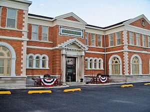
Decatur station (Illinois)
Distance: Approx. 1851 meters
Latitude and longitude: 39.84722222,-88.94638889
The Decatur station, also known as the Wabash Railroad Station and Railway Express Agency, is a historic railway station located at 780 East Cerro Gordo Street in Decatur, Illinois. Built in 1901, the station served trains on the Wabash Railroad, the most economically significant railroad through Decatur. Architect Theodore Link designed the Classical Revival building.

Roosevelt Junior High School (Decatur, Illinois)
United States historic place
Distance: Approx. 2587 meters
Latitude and longitude: 39.85638889,-88.965
Roosevelt Junior High School is a historic school located in Decatur, Illinois, United States. Built from 1917 to 1921, the school was the second exclusive middle school in the city after the now-closed Centennial Junior High School. Decatur architectural firm Brooks, Bramhall & Dague designed the school in the Collegiate Gothic style, a popular choice for educational buildings at the time.
Decatur Downtown Historic District (Decatur, Illinois)
Historic district in Illinois, United States
Distance: Approx. 2755 meters
Latitude and longitude: 39.84222222,-88.95555556
The Decatur Downtown Historic District is a historic commercial district located in downtown Decatur, Illinois. The district includes 75 buildings, 61 of which are considered significant or contributing to its historic character. While downtown Decatur was platted in 1829, it did not experience significant commercial development until 1854, when two railroads built lines through the city; all but one of the district's contributing buildings were built between 1854 and 1916.
Weather in this IP's area
moderate rain
12 Celsius
11 Celsius
11 Celsius
12 Celsius
1007 hPa
87 %
1007 hPa
983 hPa
10000 meters
6.69 m/s
170 degree
100 %
06:38:59
16:41:25


