Country:
 USA
USARegion:
City:
Latitude and Longitude:
Time Zone:
Postal Code:
IP information under different IP Channel
ip-api
Country
Region
City
ASN
Time Zone
ISP
Blacklist
Proxy
Latitude
Longitude
Postal
Route
IPinfo
Country
Region
City
ASN
Time Zone
ISP
Blacklist
Proxy
Latitude
Longitude
Postal
Route
MaxMind
Country
Region
City
ASN
Time Zone
ISP
Blacklist
Proxy
Latitude
Longitude
Postal
Route
Luminati
Country
USRegion
il
City
decatur
ASN
Time Zone
America/Chicago
ISP
INS-AS
Latitude
Longitude
Postal
db-ip
Country
Region
City
ASN
Time Zone
ISP
Blacklist
Proxy
Latitude
Longitude
Postal
Route
ipdata
Country
Region
City
ASN
Time Zone
ISP
Blacklist
Proxy
Latitude
Longitude
Postal
Route
Popular places and events near this IP address

Decatur, Illinois
City in Macon County, Illinois, United States
Distance: Approx. 1235 meters
Latitude and longitude: 39.84142222,-88.95588056
Decatur ( dih-KAY-tər) is the largest city in and the county seat of Macon County, Illinois, United States. The city was founded in 1829 and is situated along the Sangamon River and Lake Decatur in Central Illinois. As of the 2020 census, it had a population of 70,522.
Lake Decatur
Reservoir in Decatur, Illinois
Distance: Approx. 2372 meters
Latitude and longitude: 39.81666667,-88.93333333
Lake Decatur is a 2,800-acre (11 km2) reservoir located in the city of Decatur, Illinois, USA, east of downtown. The city and lake both share the name of U.S. Navy Commodore Stephen Decatur. The lake is 613 feet (187 m) above sea level and has a watershed of 925 square miles (2,400 km2) or 592,000 acres (240,000 ha) reaching into parts of seven counties.
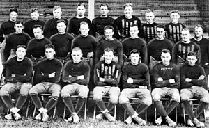
Staley Field
Sporting venue in the United States
Distance: Approx. 1788 meters
Latitude and longitude: 39.84666667,-88.92638889
Staley Field in Decatur, Illinois, United States, was the home of the Decatur Staleys club of the American Professional Football Association in 1920, coached and managed by the young George Halas, who also played for the team. The team was owned by the A. E. Staley Manufacturing Company, for which Staley Field was the company athletic field. Staley Field was also used by the company baseball team during the summer months, and Halas also played on that team.
Decatur Township, Macon County, Illinois
Township in Illinois, United States
Distance: Approx. 2521 meters
Latitude and longitude: 39.85,-88.96666667
Decatur Township is in Macon County, Illinois. At the 2010 census, its population was 52,915 and it contained 24,918 housing units.

Stephen Decatur High School (Decatur, Illinois)
Former school in Illinois
Distance: Approx. 1247 meters
Latitude and longitude: 39.8452,-88.9523
Stephen Decatur High School was a public high school in Decatur, Illinois, United States, which existed from 1862 to 2000. Stephen Decatur High School was simply known as Decatur High School until 1957, when the city's only high school was joined by Lakeview High School (a small rural district absorbed by consolidation), and MacArthur and Eisenhower High Schools, which were newly constructed to accommodate the student population that was exploding as a result of the post-World War 2 "baby boom". The school, like the city, was named after Stephen Decatur, Jr.
Elwin, Illinois
Census-designated place in Illinois, United States
Distance: Approx. 1670 meters
Latitude and longitude: 39.85166667,-88.94416667
Elwin is an unincorporated community and census-designated place (CDP) in South Wheatland Township, Macon County, Illinois, United States. It was first listed as a CDP in 2020, with a population of 119.
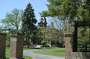
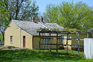
James Millikin House
Historic house in Illinois, United States
Distance: Approx. 2145 meters
Latitude and longitude: 39.84194444,-88.96694444
The James Millikin House is a historic house located at 125 N. Pine St. in Decatur, Illinois. The house was built in 1876 for James Millikin, a wealthy Decatur businessman who later founded Millikin University.

Transfer House (Decatur, Illinois)
United States historic place
Distance: Approx. 1108 meters
Latitude and longitude: 39.8425,-88.95333333
The Transfer House is a historic building located in Central Park in Decatur, Illinois. Built in 1896, the building originally served as a transfer point for Decatur's electric streetcar system. Architect William W. Boyington's design for the building was influenced by a number of Victorian styles, particularly the Richardsonian Romanesque.
Decatur station (Illinois)
Distance: Approx. 1211 meters
Latitude and longitude: 39.84722222,-88.94638889
The Decatur station, also known as the Wabash Railroad Station and Railway Express Agency, is a historic railway station located at 780 East Cerro Gordo Street in Decatur, Illinois. Built in 1901, the station served trains on the Wabash Railroad, the most economically significant railroad through Decatur. Architect Theodore Link designed the Classical Revival building.

Decatur Historic District
Historic district in Illinois, United States
Distance: Approx. 1860 meters
Latitude and longitude: 39.84222222,-88.96333333
The Decatur Historic District is a residential historic district in the Millikin Heights neighborhood of Decatur, Illinois. The district encompasses the city's historic Near West and Southwest neighborhoods and was formed beginning in the 1850s and continuing through the 1920s. Nearly all of the popular architectural styles from this period are represented in the district.

Decatur Downtown Historic District (Decatur, Illinois)
Historic district in Illinois, United States
Distance: Approx. 1252 meters
Latitude and longitude: 39.84222222,-88.95555556
The Decatur Downtown Historic District is a historic commercial district located in downtown Decatur, Illinois. The district includes 75 buildings, 61 of which are considered significant or contributing to its historic character. While downtown Decatur was platted in 1829, it did not experience significant commercial development until 1854, when two railroads built lines through the city; all but one of the district's contributing buildings were built between 1854 and 1916.
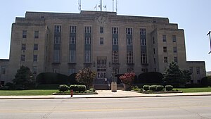
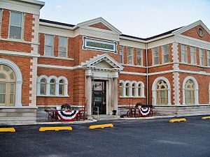
Macon County Courthouse (Illinois)
Local government building in the United States
Distance: Approx. 1017 meters
Latitude and longitude: 39.84,-88.95388889
The Macon County Courthouse is a government building in Decatur, the county seat of Macon County, Illinois, United States. Completed in 1940, it is the fourth courthouse in the county's history.
Weather in this IP's area
clear sky
32 Celsius
31 Celsius
30 Celsius
32 Celsius
1009 hPa
33 %
1009 hPa
987 hPa
10000 meters
1.94 m/s
2.36 m/s
183 degree
06:41:02
18:57:49