12.43.90.130 - IP Lookup: Free IP Address Lookup, Postal Code Lookup, IP Location Lookup, IP ASN, Public IP
Country:
Region:
City:
Location:
Time Zone:
Postal Code:
IP information under different IP Channel
ip-api
Country
Region
City
ASN
Time Zone
ISP
Blacklist
Proxy
Latitude
Longitude
Postal
Route
Luminati
Country
Region
il
City
decatur
ASN
Time Zone
America/Chicago
ISP
INS-AS
Latitude
Longitude
Postal
IPinfo
Country
Region
City
ASN
Time Zone
ISP
Blacklist
Proxy
Latitude
Longitude
Postal
Route
IP2Location
12.43.90.130Country
Region
illinois
City
decatur
Time Zone
America/Chicago
ISP
Language
User-Agent
Latitude
Longitude
Postal
db-ip
Country
Region
City
ASN
Time Zone
ISP
Blacklist
Proxy
Latitude
Longitude
Postal
Route
ipdata
Country
Region
City
ASN
Time Zone
ISP
Blacklist
Proxy
Latitude
Longitude
Postal
Route
Popular places and events near this IP address
Macon County, Illinois
County in Illinois, United States
Distance: Approx. 2060 meters
Latitude and longitude: 39.86,-88.96
Macon County is a county located in the U.S. state of Illinois. According to the 2020 United States Census, it had a population of 103,998. Its county seat and most populous city is Decatur.

Area codes 217 and 447
Area codes in west and central Illinois, United States
Distance: Approx. 1406 meters
Latitude and longitude: 39.8666667,-88.95
Area codes 217 and 447 are telephone area codes in the North American Numbering Plan (NANP) for much of the central part of the U.S. state of Illinois. The numbering plan area (NPA) includes the state capital, Springfield, and Champaign, Urbana, Decatur, Taylorville, Lincoln, Danville, Effingham, Quincy, Rantoul, and Jacksonville. 217 was one of the original North American area codes created in 1947 and 447 was added to the same area in 2021 to form an all-services overlay.

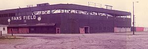
Fans Field (Decatur)
Former minor league baseball park in Decatur, IL, USA
Distance: Approx. 2561 meters
Latitude and longitude: 39.861518,-88.935893
Fans Field was a minor league baseball park in Decatur, IL. It was the home of the Decatur Commodores, of the Three-I League, Mississippi-Ohio Valley League and Midwest League, from 1927 through 1974. It was at the southeast corner of East Garfield Avenue (left field) and North Woodford Street (third base). During late 1974 and early 1975, the city debated what to do with the abandoned ballpark.

Decatur Township, Macon County, Illinois
Township in Illinois, United States
Distance: Approx. 3270 meters
Latitude and longitude: 39.85,-88.96666667
Decatur Township is in Macon County, Illinois. At the 2010 census, its population was 52,915 and it contained 24,918 housing units.

St. Teresa High School (Decatur, Illinois)
Private school in Decatur, Illinois, United States
Distance: Approx. 680 meters
Latitude and longitude: 39.8725,-88.95388889
St. Teresa High School is a private, Roman Catholic high school in Decatur, Illinois. It is located in the Roman Catholic Diocese of Springfield in Illinois.
MacArthur High School (Decatur, Illinois)
Public school in the United States
Distance: Approx. 3427 meters
Latitude and longitude: 39.85313,-88.97949
Douglas MacArthur High School is a public high school located in Decatur, Illinois. The school serves about 1,184 students from grades 9 to 12 in Decatur Public School District 61.
Elwin, Illinois
Census-designated place in Illinois, United States
Distance: Approx. 3144 meters
Latitude and longitude: 39.85166667,-88.94416667
Elwin is an unincorporated community and census-designated place (CDP) in South Wheatland Township, Macon County, Illinois, United States. It was first listed as a CDP in 2020, with a population of 119.
WSOY (AM)
Radio station in Decatur, Illinois
Distance: Approx. 1211 meters
Latitude and longitude: 39.87805556,-88.94222222
WSOY (1340 kHz) is a commercial AM radio station broadcasting a Talk radio format. Licensed to Decatur, Illinois, the station is owned by Neuhoff Corp., through licensee Neuhoff Media Decatur, LLC. Neuhoff owns four other local radio stations, WCZQ, WDZ, WDZQ and WSOY-FM. Studios and offices are located on North Water Street and the transmitter site is near St. Louis Bridge Road, sharing the same tower as WDZ. WSOY operates at 1,000 watts, day and night, using a non-directional antenna.
Walther Theological Seminary
Lutheran seminary in the US
Distance: Approx. 2144 meters
Latitude and longitude: 39.8642,-88.9735
Walther Theological Seminary is an institution of theological higher education in Decatur, Illinois, United States, that provides preparation of pastors for the congregations and missions of the United Lutheran Mission Association (ULMA) and other confessional Lutheran churches. The seminary offers two master's degrees, one for the training of clergy (M.Div.) and the other for lay people (M.A.). The seminary's practice and policy is to ordain only men for the ministry, in accordance with the historic biblical Lutheran view on the role of women.

Spring Creek (Macon County, Illinois)
Stream in Macon County, Illinois, U.S.
Distance: Approx. 2989 meters
Latitude and longitude: 39.8725,-88.99055556
Spring Creek is a stream in Macon County, Illinois. A tributary of Stevens Creek, itself a tributary of the Sangamon River, Spring Creek originates just northeast of the town of Forsyth before emptying into Stevens Creek west of Horace B. Garman Park in Decatur, Illinois.

Roosevelt Junior High School (Decatur, Illinois)
United States historic place
Distance: Approx. 2547 meters
Latitude and longitude: 39.85638889,-88.965
Roosevelt Junior High School is a historic school located in Decatur, Illinois, United States. Built from 1917 to 1921, the school was the second exclusive middle school in the city after the now-closed Centennial Junior High School. Decatur architectural firm Brooks, Bramhall & Dague designed the school in the Collegiate Gothic style, a popular choice for educational buildings at the time.
Decatur Correctional Center
Prison for women in Decatur, Illinois
Distance: Approx. 3104 meters
Latitude and longitude: 39.89480556,-88.92711111
Decatur Correctional Center is a prison for women in Decatur, Illinois. It is operated by the Illinois Department of Corrections (IDOC). It first opened on January 24, 2000.
Weather in this IP's area
clear sky
-9 Celsius
-16 Celsius
-12 Celsius
-9 Celsius
1025 hPa
57 %
1025 hPa
998 hPa
10000 meters
7.2 m/s
11.32 m/s
280 degree
