Country:
Region:
City:
Latitude and Longitude:
Time Zone:
Postal Code:
IP information under different IP Channel
ip-api
Country
Region
City
ASN
Time Zone
ISP
Blacklist
Proxy
Latitude
Longitude
Postal
Route
Luminati
Country
ASN
Time Zone
Asia/Jakarta
ISP
PT. DATA Utama Dinamika
Latitude
Longitude
Postal
IPinfo
Country
Region
City
ASN
Time Zone
ISP
Blacklist
Proxy
Latitude
Longitude
Postal
Route
db-ip
Country
Region
City
ASN
Time Zone
ISP
Blacklist
Proxy
Latitude
Longitude
Postal
Route
ipdata
Country
Region
City
ASN
Time Zone
ISP
Blacklist
Proxy
Latitude
Longitude
Postal
Route
Popular places and events near this IP address
Petra Christian University
Private university located in Surabaya, Indonesia.
Distance: Approx. 5834 meters
Latitude and longitude: -7.33947222,112.73752778
Petra Christian University, commonly abbreviated as PCU (Indonesian: Universitas Kristen Petra) is a major private Christian university the oldest and largest in Indonesia, located in Wonocolo District in Surabaya, East Java - Indonesia. It was established in 1961, founded by PPPK Petra, an educational Christian based in Surabaya which established in 1951. The Petra name itself is taken from the Greek language that translates as coral reef or rock.
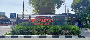
Purabaya Bus Terminal
Bus station in East Java, Indonesia
Distance: Approx. 4430 meters
Latitude and longitude: -7.35111111,112.72444444
Purabaya Bus Terminal (Indonesian: Terminal Purabaya), or Bungurasih Bus Terminal, is a type-A bus terminal serving bus services in Greater Surabaya area of Indonesia. It is located in the outskirts of Surabaya; in Bungurasih, Waru, Sidoarjo Regency, East Java. It serves local and inter-island routes.
Nahdlatul Ulama Museum
History and culture museum in Surabaya, Indonesia
Distance: Approx. 5867 meters
Latitude and longitude: -7.33822222,112.72380556
The Nahdlatul Ulama Museum (Indonesian: Museum Nahdlatul Ulama) is an Indonesian museum that documents the culture and history of the Nahdatul Ulama (NU). Opened on 25 November 2004 by Abdurrahman Wahid, the museum is located in Surabaya, Indonesia. The NU Congress inaugurated the museum with the help of Ra'is Aam as Chairman of NU and KH. M. Sahal Mahfudh.
Polygon Bikes
Indonesian bicycle manufacturer
Distance: Approx. 3234 meters
Latitude and longitude: -7.419807,112.729034
Polygon Bikes is a bicycle's trade name made by PT Insera Sena, an Indonesian bicycle manufacturer based in Sidoarjo, East Java. Polygon operates manufacturing facilities in various places in Indonesia. Polygon has a globally connected design team, and commonly used as sponsor and its bike in bicycle competition.

Mpu Tantular Museum
Ethnographic museum in East Java, Indonesia
Distance: Approx. 4867 meters
Latitude and longitude: -7.433982,112.719922
Mpu Tantular Museum is a State Museum (Museum Negeri) located in Buduran, Sidorajo, East Java, a province of Indonesia. Formerly the Stedelijk Historisch Museum Soerabaia, the museum began as a society established by Godfried Hariowald von Faber in 1933. Today, the museum was the State Museum of the Province of East Java "Mpu Tantular".
Avian Tower
Skyscraper in Surabaya, Indonesia
Distance: Approx. 5339 meters
Latitude and longitude: -7.34299019,112.73043844
Avian Tower is a high-rise building located in Surabaya, Indonesia. It serves as the headquarters of Avian Brands The Tower is 84 meters tall, with 20 stories. The tower is a twisted tower, the floor rotates an average 3°, and the tower itself rotate 60°.

Kertomenanggal railway station
Railway station in Indonesia
Distance: Approx. 5601 meters
Latitude and longitude: -7.340578,112.729508
Kertomenanggal Station (KTL) is an inactive railway station located in Menanggal, Gayungan, Surabaya. This station is included in the Operation Area VIII Surabaya and is a railway station that is located in the southernmost city of Surabaya. This station is 1.2 km (0.75 mi) from Waru Station to the north, to be precise near the Surabaya Golkar Building.
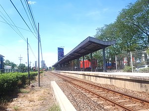
Sawotratap railway station
Railway station in Indonesia
Distance: Approx. 2496 meters
Latitude and longitude: -7.3685,112.729
Sawotratap Station (STP) is an inactive railway station located in Sawotratap, Gedangan, Sidoarjo Regency. The station is included in the Operation Area VIII Surabaya. Previously, the station only served the Surabaya–Bangil Commuter service.
Waru railway station
Railway station in Indonesia
Distance: Approx. 4259 meters
Latitude and longitude: -7.35264,112.729324
Waru Station (WR) is a class II railway station located in Kedungrejo, Waru, Sidoarjo Regency, East Java, Indonesia included in the Operation Area VIII Surabaya at an altitude of +5 meters (16 ft). The station is strategically located on the Surabaya–Sidoarjo main route and close to Purabaya Bus Terminal. Tracks 3 and 4 were previously used for container loading and unloading activities from Tanjung Priuk and Kalimas, these trains only operate once in two days.

Gedangan railway station (Sidoarjo)
Railway station in Indonesia
Distance: Approx. 309 meters
Latitude and longitude: -7.38889,112.729
Gedangan Station (GDG) is a class III railway station located in Gedangan, Gedangan, Sidoarjo Regency, included in Operation Area VIII Surabaya at an altitude of +4 meters.
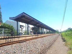
Pagerwojo railway station
Railway station in Indonesia
Distance: Approx. 5820 meters
Latitude and longitude: -7.44174,112.715
Pagerwojo Station (PWJ) is an inactive railway station located in Pucang, Sidoarjo, Sidoarjo Regency. The station is included in the Operation Area VIII Surabaya. Previously, the station only served the Surabaya–Bangil Commuter service.
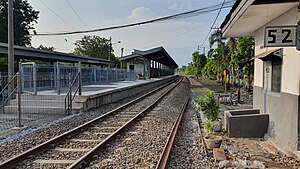
Buduran railway station
Railway station in Indonesia
Distance: Approx. 4128 meters
Latitude and longitude: -7.4277,112.723
Buduran Station (BDR) is an inactive railway station located in Buduran, Buduran, Sidoarjo Regency, Indonesia. The station was included in the Operation Area VIII Surabaya. Previously, the station only served the Surabaya–Bangil Commuter service.
Weather in this IP's area
few clouds
33 Celsius
40 Celsius
33 Celsius
33 Celsius
1005 hPa
62 %
1005 hPa
1005 hPa
10000 meters
5.14 m/s
70 degree
20 %
05:00:28
17:28:21
