119.30.12.180 - IP Lookup: Free IP Address Lookup, Postal Code Lookup, IP Location Lookup, IP ASN, Public IP
Country:
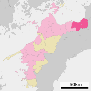
 Japan
JapanRegion:
City:
Location:
Time Zone:
Postal Code:
ISP:
ASN:
language:
User-Agent:
Proxy IP:
Blacklist:
IP information under different IP Channel
ip-api
Country
Region
City
ASN
Time Zone
ISP
Blacklist
Proxy
Latitude
Longitude
Postal
Route
db-ip
Country
Region
City
ASN
Time Zone
ISP
Blacklist
Proxy
Latitude
Longitude
Postal
Route
IPinfo
Country
Region
City
ASN
Time Zone
ISP
Blacklist
Proxy
Latitude
Longitude
Postal
Route
IP2Location
119.30.12.180Country
jpRegion
ehime
City
shikokuchuo
Time Zone
Asia/Tokyo
ISP
Language
User-Agent
Latitude
Longitude
Postal
ipdata
Country
Region
City
ASN
Time Zone
ISP
Blacklist
Proxy
Latitude
Longitude
Postal
Route
Popular places and events near this IP address
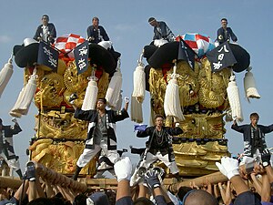
Shikokuchūō
City in Shikoku, Japan
Distance: Approx. 37 meters
Latitude and longitude: 33.98333333,133.55
Shikokuchūō (四国中央市, Shikokuchūō-shi, lit. "Central Shikoku City") is a city located in Ehime Prefecture, Japan. As of August 31, 2022, the city had an estimated population of 83,635 in 28876 households and a population density of 200 persons per km².

Minoura Station
Railway station in Ka'onji, Kagawa Prefecture, Japan
Distance: Approx. 9669 meters
Latitude and longitude: 34.048,133.6195
Minoura Station (箕浦駅, Minoura-eki) is a passenger railway station located in the city of Kan'onji, Kagawa Prefecture, Japan. It is operated by JR Shikoku and has the station number "Y21".

Kawanoe Station
Railway station in Shikokuchūō, Ehime Prefecture, Japan
Distance: Approx. 4334 meters
Latitude and longitude: 34.0152,133.5764
Kawanoe Station (川之江駅, Kawanoe-eki) is a passenger railway station located in the city of Shikokuchūō, Ehime Prefecture, Japan. It is operated by JR Shikoku and has the station number "Y22".

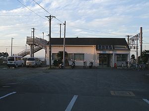
Iyo-Mishima Station
Railway station in Shikokuchūō, Ehime Prefecture, Japan
Distance: Approx. 824 meters
Latitude and longitude: 33.9794,133.5422
Iyo-Mishima Station (伊予三島駅, Iyo-Mishima-eki) is a passenger railway station located in the city of Shikokuchūō, Ehime Prefecture, Japan. It is operated by JR Shikoku and has the station number "Y23".
Iyo-Sangawa Station
Railway station in Shikokuchūō, Ehime Prefecture, Japan
Distance: Approx. 4904 meters
Latitude and longitude: 33.9679,133.5001
Iyo-Sangawa Station (伊予寒川駅, Iyo-Sangawa-eki) is a passenger railway station located in the city of Shikokuchūō, Ehime Prefecture, Japan. It is operated by JR Shikoku and has the station number "Y24".

Akaboshi Station
Railway station in Shikokuchūō, Ehime Prefecture, Japan
Distance: Approx. 8833 meters
Latitude and longitude: 33.96673056,133.45635
Akaboshi Station (赤星駅, Akaboshi-eki) is a passenger railway station located in the city of Shikokuchūō, Ehime Prefecture, Japan. It is operated by JR Shikoku and has the station number "Y25".

Dōzan River
River in Japan
Distance: Approx. 6542 meters
Latitude and longitude: 33.92840556,133.52377778
The Dōzan River (銅山川, Dōzan-gawa) is the largest branch of the Yoshino River and flows through Ehime and Tokushima prefectures in Japan. Its name was derived from the Besshi copper mine that is now closed. In Tokushima Prefecture, it is called the Iyo River (伊予川 Iyo-gawa).
Ehime Prefectural Mishima High School
Public high school in Japan
Distance: Approx. 589 meters
Latitude and longitude: 33.979097,133.545685
Ehime Prefectural Mishima High School (愛媛県立三島高等学校, Ehime Kenritsu Mishima Kōtōgakkō) is a public high school located in Mishimachūō, Shikokuchūō, Ehime, Shikoku, Japan opened in 1923 as the Ehime Prefectural Mishima Middle School (愛媛県立三島中学校, Ehime Kenritsu Mishima Chūgakkō).

Kinshako Prefectural Natural Park
Distance: Approx. 5023 meters
Latitude and longitude: 33.938,133.554
Kinshako Prefectural Natural Park (金砂湖県立自然公園, Kinshako kenritsu shizen-kōen) is a Prefectural Natural Park in northeast Ehime Prefecture, Japan. Established in 1961, the park is wholly situated within the municipality of Shikokuchūō. The park's central feature is the eponymous Lake Kinsha.
Weather in this IP's area
light snow
1 Celsius
-6 Celsius
1 Celsius
1 Celsius
1020 hPa
64 %
1020 hPa
984 hPa
10000 meters
9.12 m/s
11.37 m/s
286 degree
92 %