119.252.115.57 - IP Lookup: Free IP Address Lookup, Postal Code Lookup, IP Location Lookup, IP ASN, Public IP
Country:
 Federated States of Micronesia
Region:
City:
Location:
Time Zone:
Postal Code:
ISP:
ASN:
language:
User-Agent:
Proxy IP:
Blacklist:
IP information under different IP Channel
ip-api
Country
Region
City
ASN
Time Zone
ISP
Blacklist
Proxy
Latitude
Longitude
Postal
Route
db-ip
Country
Region
City
ASN
Time Zone
ISP
Blacklist
Proxy
Latitude
Longitude
Postal
Route
IPinfo
Country
Region
City
ASN
Time Zone
ISP
Blacklist
Proxy
Latitude
Longitude
Postal
Route
IP2Location
119.252.115.57Country
fmRegion
pohnpei
City
kolonia
Time Zone
Pacific/Pohnpei
ISP
Language
User-Agent
Latitude
Longitude
Postal
ipdata
Country
Region
City
ASN
Time Zone
ISP
Blacklist
Proxy
Latitude
Longitude
Postal
Route
Popular places and events near this IP address
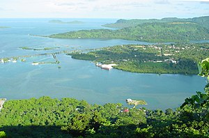
Kolonia
Place in Pohnpei, Federated States of Micronesia
Distance: Approx. 183 meters
Latitude and longitude: 6.96388889,158.20805556
Kolonia is a coastal town and the capital of Pohnpei State in the Federated States of Micronesia (FSM). It's not to be confused with the far smaller Colonia, the capital of the State of Yap. It was also the former FSM capital before being replaced by Palikir in 1989, located nearby to the southwest in the municipality of Sokehs.

Western and Central Pacific Fisheries Commission
Regional fisheries management organisation
Distance: Approx. 766 meters
Latitude and longitude: 6.9666024,158.2128149
The Western and Central Pacific Fisheries Commission (WCPFC) is a regional fisheries management organisation established to conserve and manage tuna and other highly migratory fish stocks across the western and central areas of the Pacific Ocean. Its full name is Commission for the Conservation and Management of Highly Migratory Fish Stocks in the Western and Central Pacific Ocean. It commenced operations in late 2005, and its secretariat is based in Pohnpei, in the northern Pacific state of the Federated States of Micronesia.
Our Lady of Mercy Catholic High School (Micronesia)
High school in Kolonia, Pohnpei State, Federated States of Micronesia
Distance: Approx. 751 meters
Latitude and longitude: 6.967868,158.211963
Our Lady Of Mercy Catholic High School (OLMCHS) is a Catholic school located in the Kolonia, Pohnpei Island, Pohnpei State, Federated States of Micronesia. OLMCHS is an academic high school. It is being staffed by the Spanish Mercederian Sisters and volunteers from the United States of America and Latin America.

Catholic Belltower
United States historic place
Distance: Approx. 746 meters
Latitude and longitude: 6.96841667,158.21147222
The Catholic Belltower (also known as the Cathedral of Ponape Belltower and Ponape Belltower) is a historic tower at the Catholic Mission in Kolonia, on the island of Pohnpei in the Federated States of Micronesia. The belltower and adjoining masonry apse are all that remain of a church built in 1909 by German and Spanish Capuchin missionaries, when Ponape and the other Caroline Islands were administered as part of German New Guinea. The rest of the church was destroyed during the fighting of World War II. The tower is 4.8 square metres (52 sq ft), rising to a height of 20.7 metres (68 ft), and the shell of the apse is about 10 metres (33 ft) in height.
Chief Agriculturist House
United States historic place
Distance: Approx. 728 meters
Latitude and longitude: 6.95916667,158.21083333
The Chief Agriculturist House is a historic house in Kolonia, the capital of Pohnpei State in the Federated States of Micronesia. It is a steel and concrete structure, built in the mid-1920s when Pohnpei and the other Caroline Islands were part of the Japanese South Seas Mandate. It was one of the highest-quality buildings constructed on Pohnpei during the Japanese administration, and was the home of the Japanese weatherman and agricultural overseer, said to be the second most powerful figure in Japanese Micronesia.
Japanese Hydro-electric Power Plant
United States historic place
Distance: Approx. 477 meters
Latitude and longitude: 6.95972222,158.20666667
The Japanese Hydro-electric Power Plant is a former hydroelectric power generation plant and historic site in Kolonia, the capital of Pohnpei State in the Federated States of Micronesia. The site is historically and culturally important as a representative of three different eras in the island's history. The site is important in the culture of Pohnpei as a location of high-quality stones gathered for use in ritual ceremonies involving the pounding of kava and drinking preparations from the plant.
Japanese Shrine (Pohnpei)
United States historic place
Distance: Approx. 674 meters
Latitude and longitude: 6.96416667,158.2125
The Japanese Shrine is a Shinto shrine in Kolonia, the capital of Pohnpei State in the Federated States of Micronesia. The official name at that time was Japanese: 南洋庁ポナペ国民学校奉安殿, romanized: Nan'yō Chō Ponape Kokumin Gakkō Hō-an-den, lit. 'Nan'yō Government Ponape National School Hōanden'. It is a concrete structure, about 8 by 4 feet (2.4 m × 1.2 m) and 10–12 feet (3.0–3.7 m) in height.

Japanese Artillery Road and Pohndolap Area
United States historic place
Distance: Approx. 1690 meters
Latitude and longitude: 6.96444444,158.19111111
The Japanese Artillery Road and Pohndolap Area are a historic area on Sokehs Island (now actually a peninsula of Pohnpei) in the Federated States of Micronesia. Sokehs has a prominent north-south ridge (known locally as "Pohndolap", overlooking the state capital Kolonia, and was fortified by the Japanese during World War II. They built a road to the summit area and emplaced anti-aircraft guns on the ridge. The ridge was also a key site in the 1910 Sokehs Rebellion against German rule, and the remnants of a Pohnpeian fort are also in the area.

Spanish Wall
United States historic place
Distance: Approx. 718 meters
Latitude and longitude: 6.96777778,158.21166667
The Spanish Wall is the deteriorating remnant of Spanish Fort Alphonso XIII in Kolonia, the capital of Pohnpei State in the Federated States of Micronesia. When built, the wall was about 0.5 miles (0.80 km) in length and 8 feet (2.4 m) in height with a parapet that ranged in height from 2–3 feet (0.61–0.91 m). The wall was built by Spanish administrators of Pohnpei in 1887 after a local uprising drove the local Spanish authorities onto a ship in the harbor.
Sokehs Mass Grave Site
United States historic place
Distance: Approx. 645 meters
Latitude and longitude: 6.96672222,158.21155556
The Sokehs Mass Grave Site is the location where fifteen participants of the 1910/1911 Sokehs Rebellion on the island of Pohnpei were buried by German colonial authorities. The rebellion broke out in October 1910 on Sokehs Island and was suppressed by German naval forces by early 1911. At a summary trial of 36 Sokehs rebels, 17 were convicted of murder and insurrection, and 15 subsequently executed by firing squad and buried in this mass grave.
Japanese Elementary School for Ponapean Children
United States historic place
Distance: Approx. 658 meters
Latitude and longitude: 6.96722222,158.21138889
The Japanese Elementary School for Ponapean Children is a historic school building in Kolonia, the capital of Pohnpei State in the Federated States of Micronesia. The surviving building is one of two reinforced concrete buildings, constructed c. 1920-21 by the Japanese authorities of the South Seas Mandate, which included the island of Pohnpei, then known as "Ponape".
Bailey Olter High School
High school in Kolonia, Pohnpei Island, Pohnpei State, Federated States of Micronesia
Distance: Approx. 1625 meters
Latitude and longitude: 6.9497222,158.2033333
Bailey Olter High School, formerly Pohnpei Island Central School (PICS), and Pacific Islands Central School, is a senior high school in Kolonia, Pohnpei Island, Pohnpei State, Federated States of Micronesia. As of 2018 the school, operated by the Pohnpei State Department of Education, has about 1,500 students, making it the state's largest high school. Its service area includes Kolonia, Nett, Sokehs (including the FSM capital Palikir), and U. PICS was the first senior high school on the island of Pohnpei; it was originally the sole senior high school in the Trust Territory of the Pacific Islands, and for a period then only secondary school in the Micronesia region.
Weather in this IP's area
light intensity shower rain
25 Celsius
26 Celsius
25 Celsius
25 Celsius
1013 hPa
94 %
1013 hPa
1010 hPa
10000 meters
100 %