Country:
 India
IndiaRegion:
City:
Latitude and Longitude:
Time Zone:
Postal Code:
IP information under different IP Channel
ip-api
Country
Region
City
ASN
Time Zone
ISP
Blacklist
Proxy
Latitude
Longitude
Postal
Route
IPinfo
Country
Region
City
ASN
Time Zone
ISP
Blacklist
Proxy
Latitude
Longitude
Postal
Route
MaxMind
Country
Region
City
ASN
Time Zone
ISP
Blacklist
Proxy
Latitude
Longitude
Postal
Route
Luminati
Country
INASN
Time Zone
Asia/Kolkata
ISP
Sify Limited
Latitude
Longitude
Postal
db-ip
Country
Region
City
ASN
Time Zone
ISP
Blacklist
Proxy
Latitude
Longitude
Postal
Route
ipdata
Country
Region
City
ASN
Time Zone
ISP
Blacklist
Proxy
Latitude
Longitude
Postal
Route
Popular places and events near this IP address
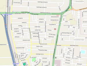
Adyar, Chennai
Neighborhood of Chennai, India
Distance: Approx. 987 meters
Latitude and longitude: 13.0063,80.2574
Adyar is a large neighbourhood in south Chennai, Tamil Nadu, India. It is among the most upscale neighborhoods in Chennai. It is located on the southern banks of the Adyar River.
Alagappa College of Technology
Indian educational institution
Distance: Approx. 1091 meters
Latitude and longitude: 13.007906,80.238795
Alagappa College of Technology is an educational institution located in Chennai, Tamil Nadu, India that offers higher education in engineering, technology and allied sciences. The college was established in 1944 and was integrated with Anna University in 1978 from University of Madras as a constituent part of Anna University within its Guindy Campus.
Anna University School of Architecture and Planning
Architectural school of Anna University
Distance: Approx. 987 meters
Latitude and longitude: 13.0076,80.2397
School of Architecture and Planning (SAP) is one of the four constituent colleges of Anna University, Chennai, Tamil Nadu (India). It was established as a Department of Architecture of the University of Madras in 1957 and was located in the Alagappa College of Technology. The department was later renamed as the School of Architecture and Planning and shifted to its own independent campus in 1968.
Asian College of Journalism, Chennai
Journalism school in Chennai, Tamil Nadu, India
Distance: Approx. 1032 meters
Latitude and longitude: 12.995967,80.246249
The Asian College of Journalism (ACJ) is a journalism school in Chennai, India, which offers postgraduate diploma courses in journalism.

Madhya Kailash
Hindu temple in South Chennai, India
Distance: Approx. 221 meters
Latitude and longitude: 13.00638889,80.24694444
Madhya Kailash (Tamil: மத்திய கைலாசம்), also known as Nadukkayilai in Tamil, is a Hindu temple in South Chennai, located at the junction between Sardar Patel Road, Adyar and Rajiv Gandhi Salai. It is located opposite the Central Leather Research Institute and is close to the Indian Institute of Technology, Chennai.
Central Polytechnic Chennai
College in Tamil Nadu, India
Distance: Approx. 577 meters
Latitude and longitude: 13,80.247
Central Polytechnic Chennai is a polytechnic in Tamil Nadu.
Gandhi Nagar, Chennai
Neighbourhood in Chennai, India
Distance: Approx. 579 meters
Latitude and longitude: 13.007736,80.252938
Gandhi Nagar is a neighbourhood in Adyar, in the south eastern part of the Indian city of Chennai. It is among the most upscale neighborhoods in Chennai. Property prices in Gandhi Nagar have been increasing significantly.
Madhya Kailash Junction
Bridge in Chennai, India
Distance: Approx. 222 meters
Latitude and longitude: 13.006722,80.247369
The Madhya Kailash Junction is an important junction in the southern part of the city of Chennai. It is located at the beginning of the Rajiv Gandhi Salai (IT Expressway) which intersects the Sardar Patel Road in the form of "T".

Adyar Ananda Bhavan
Indian vegetarian restaurant chain
Distance: Approx. 1003 meters
Latitude and longitude: 13.0059,80.2576
Adyar Ananda Bhavan (also known as AAB or A2B) is an Indian chain of vegetarian restaurants and confectioners founded in Rajapalayam and headquartered in Adyar, Chennai. It is the oldest chain of restaurants in Chennai and has 145+ outlets across India.
Roja Muthiah Research Library
Research library in Chennai, India
Distance: Approx. 797 meters
Latitude and longitude: 12.997841,80.248464
The Roja Muthiah Research Library (RMRL), in Chennai, India, was founded in 1994, and opened to researchers in 1996; it provides research materials for Tamil studies in a variety of fields of the humanities, social sciences, and sciences. The Library is based on the collection of Roja Muthiah, who accumulated one of the world's finest private libraries of Tamil publications.
Voluntary Health Services hospital, Chennai
Hospital in Tamil Nadu, India
Distance: Approx. 350 meters
Latitude and longitude: 13.00277778,80.24611111
Voluntary Health Services, popularly known as the VHS Hospital, is a multispecialty tertiary care referral hospital in the south Indian state of Tamil Nadu, reportedly serving the economically weaker sections of the society. It was founded in 1958 by Krishnaswami Srinivas Sanjivi, an Indian physician, social worker and a winner of Padma Shri and Padma Bhushan awards and is run by a charitable non governmental organization of the same name. The hospital is situated along Rajiv Gandhi Salai at Taramani, in Chennai.

Adyar Creek
Backwater estuary in Adyar, Chennai, India
Distance: Approx. 583 meters
Latitude and longitude: 13,80.25
Adyar Creek is a backwater estuary located in Adyar, Chennai at the mouth of the Adyar River along the Coromandel Coast of the Bay of Bengal. The creek begins near the Chetinnad Palace, extending northward into the mainland and taking a complete U-turn near the Foreshore Estate before ending near Mandavelipakkam. The creek surrounds the Quibble Island.
Weather in this IP's area
mist
28 Celsius
33 Celsius
27 Celsius
28 Celsius
1008 hPa
92 %
1008 hPa
1007 hPa
5000 meters
1.03 m/s
40 %
05:59:43
17:47:52