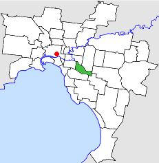
Country:
 Australia
Region:
City:
Latitude and Longitude:
Time Zone:
Postal Code:
IP information under different IP Channel
ip-api
Country
Region
City
ASN
Time Zone
ISP
Blacklist
Proxy
Latitude
Longitude
Postal
Route
IPinfo
Country
Region
City
ASN
Time Zone
ISP
Blacklist
Proxy
Latitude
Longitude
Postal
Route
MaxMind
Country
Region
City
ASN
Time Zone
ISP
Blacklist
Proxy
Latitude
Longitude
Postal
Route
Luminati
Country
AURegion
vic
ASN
Time Zone
Australia/Melbourne
ISP
Aussie Broadband
Latitude
Longitude
Postal
db-ip
Country
Region
City
ASN
Time Zone
ISP
Blacklist
Proxy
Latitude
Longitude
Postal
Route
ipdata
Country
Region
City
ASN
Time Zone
ISP
Blacklist
Proxy
Latitude
Longitude
Postal
Route
Popular places and events near this IP address
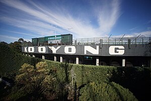
Kooyong, Victoria
Suburb of Melbourne, Victoria, Australia
Distance: Approx. 175 meters
Latitude and longitude: -37.84194444,145.035
Kooyong () is a suburb in Melbourne, Victoria, Australia, 7 km south-east of Melbourne's Central Business District, located within the City of Stonnington local government area. Kooyong recorded a population of 842 at the 2021 census. Kooyong is the second most expensive suburb of Melbourne, with a median house price of $3.585 million.

Kooyong railway station
Railway station in Melbourne, Australia
Distance: Approx. 444 meters
Latitude and longitude: -37.8399,145.03337
Kooyong railway station is a commuter railway station on the Glen Waverley line, which is part of the Melbourne railway network. It serves the eastern suburb of Kooyong, in Melbourne, Victoria, Australia. Kooyong station is a ground level unstaffed station, featuring two side platforms.

Tooronga railway station
Railway station in Melbourne, Australia
Distance: Approx. 843 meters
Latitude and longitude: -37.84939,145.0417
Tooronga railway station is a commuter railway station on the Glen Waverley line, which is part of the Melbourne railway network. It serves the eastern suburb of Malvern, in Melbourne, Victoria, Australia. Tooronga station is a ground level unstaffed station, featuring two side platforms.

Bialik College
School in Australia
Distance: Approx. 673 meters
Latitude and longitude: -37.8421,145.0435
Bialik College is a private comprehensive co-educational early learning, primary and secondary Jewish day school, located in the Melbourne suburb of Hawthorn, Victoria, Australia. Established in 1942 in Carlton North, Victoria, the school has had a Zionist orientation since its inception, with the establishment of the State of Israel central to its identity. Bialik's approach to Judaism is pluralistic and cross-communal.

Kooyong Stadium
Australian tennis venue
Distance: Approx. 658 meters
Latitude and longitude: -37.83833333,145.03194444
Kooyong Stadium, at the Kooyong Lawn Tennis Club, is an Australian tennis venue, located in the Melbourne suburb of Toorak, adjacent to the namesake suburb of Kooyong. The stadium was built in 1927, and has undergone several renovations. It has a seating capacity of slightly more than 5,000.

Gardiners Creek
River in Victoria, Australia
Distance: Approx. 1134 meters
Latitude and longitude: -37.83333333,145.03333333
Gardiners Creek, originally known as Kooyongkoot Creek, is an urban stream in the eastern suburbs of Melbourne, and part of the Yarra River catchment. Apart from a few sparse surviving remnant riparian bushlands, the majority of the creek's length has been heavily urbanised, and it has been degraded in much the same way as other Melbourne eastern suburban streams such as the Mullum Mullum Creek and Koonung Creek. The Gardiners Creek Trail follows the creek for most of its length.
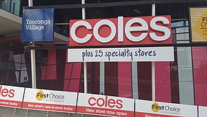
Tooronga Village
Shopping mall in Victoria, Australia
Distance: Approx. 896 meters
Latitude and longitude: -37.84611111,145.04555556
Tooronga Village is a residential, office and retail centre in the suburb of Glen Iris in Melbourne, the capital of the Australian state of Victoria. It formerly referred solely to a shopping centre, which temporarily closed in March 2008. The mixed-use redevelopment by Stockland covers the former shopping centre site and part of the adjacent former brickworks site.

Stonington mansion
Former Australian Government House in Melbourne
Distance: Approx. 737 meters
Latitude and longitude: -37.848934,145.03159
Stonington (formerly Stonnington) is a private residence and former Australian Government House located in the Melbourne suburb of Malvern, at 336 Glenferrie Road. The house was built for John Wagner, a partner in Cobb and Co coaches. Stonington gave its name to the City of Stonnington, a Melbourne municipality.
City of Malvern
Former local government area in Victoria, Australia
Distance: Approx. 782 meters
Latitude and longitude: -37.85,145.03333333
The City of Malvern was a local government area about 9 kilometres (6 mi) southeast of Melbourne, the state capital of Victoria, Australia. The city covered an area of 15.88 square kilometres (6.13 sq mi), and existed from 1856 until 1994, when it was merged with the City of Prahran to create the City of Stonnington.

Auburn High School (Victoria)
Public high school in Hawthorn East, Melbourne, Victoria, Australia
Distance: Approx. 678 meters
Latitude and longitude: -37.839385,145.041911
Auburn High School is a public co-educational high school located in Hawthorn East, Melbourne, Victoria, Australia, serving Year 7 to Year 12. Formerly known as Hawthorn Secondary College, it was re-established under its current name in January 2014. Auburn High School is the only Victorian government secondary school to be offering a Binational French program.
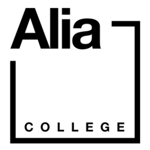
Alia College
School
Distance: Approx. 791 meters
Latitude and longitude: -37.8433,145.045
Alia College is an independent co-educational alternative secondary school located in Hawthorn East, Melbourne, Victoria, Australia. The school is built around values of tolerance, creativity, self-expression, respect and responsibility. Advertising itself as a "non rule-based school", Alia College does not have a school uniform, allows its students to leave the school premises and does not impose any formal punishments such as detentions.
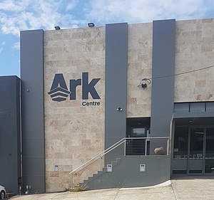
Ark Centre
Distance: Approx. 593 meters
Latitude and longitude: -37.842999,145.042733
Ark Centre is a modern Orthodox synagogue and Community Centre located in the Melbourne suburb of Hawthorn East. It was founded by a number of people who were previously members of Kew Hebrew Congregation.
Weather in this IP's area
overcast clouds
10 Celsius
10 Celsius
9 Celsius
11 Celsius
1028 hPa
88 %
1028 hPa
1026 hPa
10000 meters
0.45 m/s
3.13 m/s
242 degree
92 %
06:17:16
18:11:43