Country:
 Pakistan
Region:
City:
Latitude and Longitude:
Time Zone:
Postal Code:
IP information under different IP Channel
ip-api
Country
Region
City
ASN
Time Zone
ISP
Blacklist
Proxy
Latitude
Longitude
Postal
Route
IPinfo
Country
Region
City
ASN
Time Zone
ISP
Blacklist
Proxy
Latitude
Longitude
Postal
Route
MaxMind
Country
Region
City
ASN
Time Zone
ISP
Blacklist
Proxy
Latitude
Longitude
Postal
Route
Luminati
Country
PKASN
Time Zone
Asia/Karachi
ISP
IX Peering for Mobilink and Link Direct International.
Latitude
Longitude
Postal
db-ip
Country
Region
City
ASN
Time Zone
ISP
Blacklist
Proxy
Latitude
Longitude
Postal
Route
ipdata
Country
Region
City
ASN
Time Zone
ISP
Blacklist
Proxy
Latitude
Longitude
Postal
Route
Popular places and events near this IP address

Blue Area
Central Business District in Pakistan
Distance: Approx. 315 meters
Latitude and longitude: 33.7182,73.0714
Blue Area is the central business district of Islamabad, Pakistan along the Jinnah Avenue. The area is a 2-kilometer (1.2 mi)-long corridor along Islamabad's Khayaban-e-Quaid-e-Azam (also known as Jinnah Avenue), Islamabad's primary arterial road which leads up to the main government buildings. It is characterized by clean, wide roads and tall buildings among the panoramic greenery of the adjacent areas.
Islamabad College for Boys
Distance: Approx. 1390 meters
Latitude and longitude: 33.71818394,73.08861915
Islamabad College for Boys (ICB) is the oldest boys college in Islamabad, Pakistan, under the administration of Federal Directorate of Education (FDE). It is situated in Sector G-6/3 near Melody and Siraj Covered Markets.
Siege of Lal Masjid
2007 armed confrontation in Pakistan
Distance: Approx. 1474 meters
Latitude and longitude: 33.7128,73.087
The siege of Lal Masjid (Urdu: لال مسجد محاصرہ; code-named Operation Sunrise) was an armed confrontation in July 2007 between Islamic fundamentalist militants and the government of Pakistan, led by president Pervez Musharraf and prime minister Shaukat Aziz. The focal points of the operation were the Lal Masjid ("Red Mosque") and the Jamia Hafsa madrasah complex in Islamabad, Pakistan. Since January 2006, Lal Masjid and the adjacent Jamia Hafsa madrasah had been operated by Islamic militants led by two brothers, Abdul Aziz and Abdul Rashid.

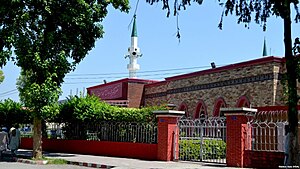
Lal Masjid, Islamabad
Mosque in Islamabad, Pakistan
Distance: Approx. 1468 meters
Latitude and longitude: 33.71286111,73.08697222
The Lal Masjid (Urdu: لال مسجد; transl. Red Mosque) is a mosque located in Islamabad, the capital of Pakistan. It is located near Abpara Market. It was constructed in 1966 and is one of the oldest mosques in the city.

ISE Tower
Office in Pakistan
Distance: Approx. 1746 meters
Latitude and longitude: 33.7119,73.0578
The ISE Tower is a high-rise building located at 55, Jinnah Avenue of the Blue Area business district of Islamabad. The building was originally designed to serve as a stock exchange building. However, following the merger of the Islamabad Stock Exchange in 2016, the tower has been repurposed as an office building.
Embassy of Afghanistan, Islamabad
Diplomatic mission
Distance: Approx. 1542 meters
Latitude and longitude: 33.72518415,73.08933486
The Embassy of Afghanistan in Islamabad is the diplomatic mission of the Islamic Emirate of Afghanistan to Pakistan. As of 2017 a new embassy was being constructed in the Diplomatic Enclave of Islamabad, to become Afghanistan's largest embassy abroad. The last Afghan ambassador to Pakistan before the fall of the Islamic Republic to the Taliban was Najibullah Alikhel.
PHA Foundation
Housing Authority of the Government of Pakistan
Distance: Approx. 766 meters
Latitude and longitude: 33.723954,73.080738
The PHA Foundation, (موَسسہ پی ایچ اے) short form for Pakistan Housing Authority Foundation, (Urdu: پاکستان موَسسہَ اختیاریہ برائے اقامت کاری) is a government body based in Islamabad, Pakistan, with offices in Lahore (31.454055°N 74.239937°E / 31.454055; 74.239937) and Karachi (24.924614°N 67.142528°E / 24.924614; 67.142528). The PHA Foundation controls and helps in building housing societies and communities in modern ways. It was established on May 18, 1999 to help improving housings.

Pakistan Engineering Council
Government of Pakistan regulating body in engineering
Distance: Approx. 1841 meters
Latitude and longitude: 33.72392752,73.09317507
The Pakistan Engineering Council (Urdu: پاکستان انجینئرنگ کونسل; acronym: PEC) is a professional body for accreditation of engineering education and regulation of engineering profession in Pakistan. It was established on 10 January 1976 by the Parliament under the PEC Act, 1976. The council also registers engineers and professional engineers and grants license to consulting and constructing/operating engineering firms working in Pakistan.
Embassy of Argentina, Islamabad
Diplomatic mission
Distance: Approx. 1644 meters
Latitude and longitude: 33.734932,73.075069
The Embassy of Argentina in Islamabad is the diplomatic mission of Argentina to Pakistan. It is located at 20, Hill Rd, F-6-3, F-6, Islamabad, Islamabad. Argentina sent its first diplomat to Pakistan in January 1948.
Embassy of Azerbaijan, Islamabad
Diplomatic mission
Distance: Approx. 1760 meters
Latitude and longitude: 33.7208,73.0928
The Embassy of Azerbaijan in Islamabad is the diplomatic mission of Azerbaijan to Pakistan. It is located at Plot 1D and 1E in Diplomatic Encave II, Islamabad. The embassy is concurrently accredited to Afghanistan.
France Colony, Islamabad
Place in Islamabad Capital Territory, Pakistan
Distance: Approx. 1222 meters
Latitude and longitude: 33.7203981,73.0606047
France Colony is a slum, or katchi abadi, in the F-7 sector of Islamabad, Pakistan. The neighborhood derives its name from the past presence of a French embassy in the area. According to The Friday Times, France Colony has low-quality electric and telecommunications networks with high electricity prices, unclean water and waste accumulation.

High Commission of Bangladesh, Islamabad
Diplomatic mission
Distance: Approx. 1793 meters
Latitude and longitude: 33.73627778,73.075
The High Commission of Bangladesh in Islamabad is the chief diplomatic mission of Bangladesh to Pakistan. It is located in Sector F-6 of Islamabad. The present Bangladeshi High Commissioner to Pakistan is Md.
Weather in this IP's area
few clouds
23 Celsius
23 Celsius
23 Celsius
23 Celsius
1013 hPa
61 %
1013 hPa
949 hPa
10000 meters
1.79 m/s
1.74 m/s
37 degree
16 %
06:06:19
17:44:24