Country:
 Pakistan
Region:
City:
Latitude and Longitude:
Time Zone:
Postal Code:
IP information under different IP Channel
ip-api
Country
Region
City
ASN
Time Zone
ISP
Blacklist
Proxy
Latitude
Longitude
Postal
Route
IPinfo
Country
Region
City
ASN
Time Zone
ISP
Blacklist
Proxy
Latitude
Longitude
Postal
Route
MaxMind
Country
Region
City
ASN
Time Zone
ISP
Blacklist
Proxy
Latitude
Longitude
Postal
Route
Luminati
Country
PKRegion
pb
City
littleattock
ASN
Time Zone
Asia/Karachi
ISP
Pakistan Telecommunication Company Limited
Latitude
Longitude
Postal
db-ip
Country
Region
City
ASN
Time Zone
ISP
Blacklist
Proxy
Latitude
Longitude
Postal
Route
ipdata
Country
Region
City
ASN
Time Zone
ISP
Blacklist
Proxy
Latitude
Longitude
Postal
Route
Popular places and events near this IP address

Kabul River
River in Afghanistan and Pakistan
Distance: Approx. 2496 meters
Latitude and longitude: 33.91666667,72.23222222
The Kabul River (Urdu: دریائے کابل, Pashto: د کابل سیند), the classical Cophen , is a 700-kilometre-long (430 mi) river that emerges in the Sanglakh Range of the Hindu Kush mountains in the northeastern part of Maidan Wardak Province, Afghanistan. It is separated from the watershed of the Helmand River by the Unai Pass. The Kabul River empties into the Indus River near Attock, Pakistan.
Mansar, Pakistan
Town in Punjab, Pakistan
Distance: Approx. 481 meters
Latitude and longitude: 33.89361111,72.24138889
Mansar (Urdu:مانسر) is a town in the Chach Valley of Attock District in Punjab Province, Pakistan. It is located close to bank of the Indus River, and the Azad Kashmir Regiment of Pakistan Army is based close to this village.
Khawari
Distance: Approx. 6463 meters
Latitude and longitude: 33.9,72.16666667
Khawari is a village of Jehangira Tehsil, Nowshera District in the Khyber Pakhtunkhwa province of Pakistan. The total Population of the village is around 7000. Most of the people of this village work abroad.
Nizampur, Khyber Pakhtunkhwa
Town in Khyber-Pakhtunkhwa, Pakistan
Distance: Approx. 1957 meters
Latitude and longitude: 33.902,72.21713889
Nizampur is a town in Jehangira tehsil of Nowshera district in Khyber Pakhtunkhwa. It is located at 33°47'7N 72°1'27E and has an altitude of 329 metres (1082 feet). The area contains reserves of iron ore.
Attock Fort
Fort in Punjab, Pakistan
Distance: Approx. 291 meters
Latitude and longitude: 33.89194444,72.23694444
Attock Fort (Urdu: قلعہ اٹک) is a fortress in Pakistan, built at Attock Khurd during the reign of Akbar from 1581 to 1583 under the supervision of Khawaja Shamsuddin Khawafi to protect the passage of the River Indus. Attock was briefly captured on 28 April 1758 by the Maratha Empire and became the northern boundary of the Maratha Empire. Ahmad Shah Durrani recaptured Attock and halted the Maratha advance in the north temporarily after the Third Battle of Panipat.
Attock Khurd
Ancient city in Punjab, Pakistan
Distance: Approx. 671 meters
Latitude and longitude: 33.9,72.23333333
Attock Khurd (Urdu: اٹک خورد; "Little Attock") is a small town located beside the Indus River in the Attock District of Punjab Province in Pakistan. Khurd and Kalan are Persian words, meaning small and big, respectively. The words are themselves derived from Middle Persian.
Attock Bridge
Distance: Approx. 2449 meters
Latitude and longitude: 33.8725,72.2368
Attock Bridge (Urdu: اٹک پل ) is situated between Attock Khurd and Khairabad Kund on Indus River in Pakistan. It is commonly known as "Old Attock Bridge". This bridge is one of the most important strategic and commercial crossing on the Indus River between Punjab and Khyber Pakhtunkhwa provinces, hence was heavily fortified.
Kund Park
Zoo in Khyber Pakhtunkhwa, Pakistan
Distance: Approx. 3771 meters
Latitude and longitude: 33.928352,72.234718
Kund Park (also known as Kund Bear Park), established in 2000, is an animal theme park located in Nowshera, Khyber Pakhtunkhwa, Pakistan. The park is a conservation center and sanctuary for Asian black bears and Himalayan brown bears. It also houses leopards as well as various species of cranes, deer, ducks, parrots, peafowls and pheasants.
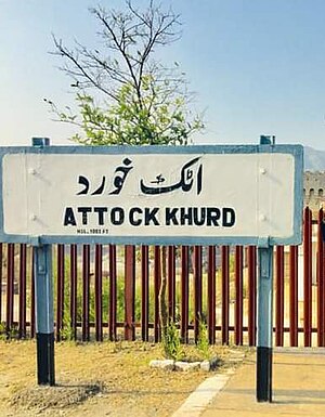
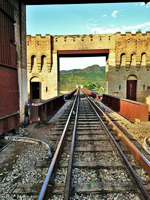
Attock Khurd railway station
Railway station in Punjab province, Pakistan
Distance: Approx. 2365 meters
Latitude and longitude: 33.8736,72.2409
Attock Khurd Railway Station (Urdu and Punjabi: اٹک خورد ریلوے اسٹیشن) is located in the town of Attock Khurd, Attock district, Punjab province, Pakistan. Special train excursions have operated to this station.
Khairabad Kund railway station
Railway station in Pakistan
Distance: Approx. 671 meters
Latitude and longitude: 33.9,72.23333333
Khairabad Kund Railway Station (Urdu: خیرآباد کنڈ ریلوے اسٹیشن, Pashto: د خیرآباد اورګاډي سټيشن) is located in the village of Khairabad, Nowshera district, Khyber Pakhtunkhwa province, Pakistan. The station is on the Karachi–Peshawar Railway Line.
Rumian railway station
Railway station in Pakistan
Distance: Approx. 7503 meters
Latitude and longitude: 33.8562,72.3031
Rumian Railway Station (Urdu and Punjabi: رومیان ریلوے اسٹیشن) is located in Rumian village, Attock district, Punjab province, Pakistan.
Khairabad, Pakistan
Town in Khyber-Pakhtunkhwa, Pakistan
Distance: Approx. 1957 meters
Latitude and longitude: 33.902,72.21713889
Khairabad (Pashto: خیرآباد , Urdu: خیرآباد ) is a town in Jehangira tehsil of Nowshera District in Khyber Pakhtunkhwa province of Pakistan. Attock is located to the east, Nizampur to the south and Jehangira town to the north.
Weather in this IP's area
light rain
30 Celsius
30 Celsius
30 Celsius
30 Celsius
1012 hPa
46 %
1012 hPa
980 hPa
10000 meters
1.32 m/s
1.8 m/s
43 degree
100 %
06:09:45
17:47:40