Country:
 Pakistan
Region:
City:
Latitude and Longitude:
Time Zone:
Postal Code:
IP information under different IP Channel
ip-api
Country
Region
City
ASN
Time Zone
ISP
Blacklist
Proxy
Latitude
Longitude
Postal
Route
IPinfo
Country
Region
City
ASN
Time Zone
ISP
Blacklist
Proxy
Latitude
Longitude
Postal
Route
MaxMind
Country
Region
City
ASN
Time Zone
ISP
Blacklist
Proxy
Latitude
Longitude
Postal
Route
Luminati
Country
PKRegion
sd
City
hyderabad
ASN
Time Zone
Asia/Karachi
ISP
Pakistan Telecommunication Company Limited
Latitude
Longitude
Postal
db-ip
Country
Region
City
ASN
Time Zone
ISP
Blacklist
Proxy
Latitude
Longitude
Postal
Route
ipdata
Country
Region
City
ASN
Time Zone
ISP
Blacklist
Proxy
Latitude
Longitude
Postal
Route
Popular places and events near this IP address
Firdous Colony
Residential neighbourhood within the city of Karachi, Pakistan
Distance: Approx. 775 meters
Latitude and longitude: 25.4,68.38333333
Firdous Colony (Urdu: فردوس کالونی), officially Firdous Cooperative Housing Society, is a neighborhood in the Karachi Central district of Karachi, Pakistan. This society was formed by Mr. Shah Masood Ahmad, who came from Bihar-India and purchased this land for his people.
Phuleli
Canal in Pakistan
Distance: Approx. 1506 meters
Latitude and longitude: 25.379994,68.383796
Phuleli is a canal in Hyderabad, Sindh, Pakistan. It's a non-perennial canal with a planned discharge capacity of 15000 cusec, was built in 1955 to address the irrigation water needs of the left bank regions of lower Sindh. The canal starts at the Ghulam Muhammad Barrage on the left side of the Indus River and runs through Hyderabad, Sindh's second biggest city.

St Bonaventure's High School
Private primary and secondary school in Hyderabad, Sindh, Pakistan
Distance: Approx. 1837 meters
Latitude and longitude: 25.393515,68.367534
St Bonaventure's High School (formerly St Bonaventure's Boys' High School) is a private Catholic primary and secondary school, located on Foujdari Road in Saddar, Hyderabad in the Sindh province of Pakistan. The school has another branch in the Hyderabad town of Qasimabad. The school is operated by the Roman Catholic diocese of Hyderabad.

Roman Catholic Diocese of Hyderabad in Pakistan
Roman Catholic diocese in Pakistan
Distance: Approx. 1881 meters
Latitude and longitude: 25.3932,68.3671
The Roman Catholic Diocese of Hyderabad (Lat: Dioecesis Hyderabadensis in Pakistan) is a diocese of the Latin Church of the Roman Catholic Church in Pakistan.
Ilyasabad
Pakistani town
Distance: Approx. 1078 meters
Latitude and longitude: 25.39538889,68.37530556
Ilyasabad (Urdu: الياس آباد) is a town in the southern suburbs of the city of Hyderabad, in Sindh, Pakistan.

Pacco Qillo
18 century fort Hyderabad, Sindh
Distance: Approx. 1654 meters
Latitude and longitude: 25.38443889,68.37268611
Pakko Qillo (Sindhi: پڪو قلعو, Strong Fort) is a fort in Hyderabad, Sindh, Pakistan. It was built in the 18th century, and served as a strategic military base and played a crucial role in the city's history.
Tando Thoro
Distance: Approx. 1606 meters
Latitude and longitude: 25.4,68.4
Tando Thoro is a suburb of Hyderabad, Sindh, Pakistan, formerly a village nearby.
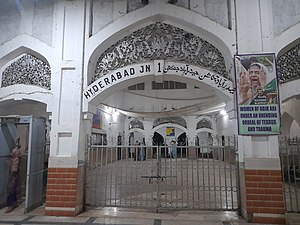
Hyderabad Junction railway station
Railway station in Sindh, Pakistan
Distance: Approx. 1845 meters
Latitude and longitude: 25.3811,68.37349892
Hyderabad Junction Railway Station (Sindhi: حيدرآباد جنڪشن ريلوي اسٽيشن) is located in the city of Hyderabad, Sindh, Pakistan and serves as a major railway junction.
Al Fazal Town, Phuleli
Distance: Approx. 775 meters
Latitude and longitude: 25.4,68.38333333
Al Fazal Town is a section of Phuleli, the name of a canal as well as a district of the city of Hyderabad, Pakistan. It was established in 1950. Al Fazal has a famous mosque, but is religiously and ethnically diverse.

Mukhi House
Museum in Hyderabad, Sindh, Pakistan
Distance: Approx. 1708 meters
Latitude and longitude: 25.3862,68.3708
The Mukhi House, also known as Mukhi Mahal, is a museum located in Hyderabad, Sindh, Pakistan. For a brief period, it housed a government school named Khadija Girls School.

Hasrat Mohani Library
Public library in Hyderabad, Pakistan
Distance: Approx. 1678 meters
Latitude and longitude: 25.385722,68.371441
Hasrat Mohani Library, also known as Hasrat Mohani District Central Library, Hyderabad, and formerly known as Holm Stead Free Readers Hall, (Urdu: حسرت موہانی لائبریری) is a public library located in Hyderabad, Sindh, Pakistan, adjacent to Pacco Qillo. It is the oldest library in the city of Hyderabad.

Navalrai Clock Tower, Hyderabad
Clock tower located in Hyderabad
Distance: Approx. 1772 meters
Latitude and longitude: 25.39884,68.36924
Navalrai Clock Tower, Hyderabad, also known as Ghanta Ghar, Hyderabad, and Market Clock Tower, Hyderabad, (Urdu: نول رائے کلاک ٹاور) is a clock tower located in Hyderabad, Sindh.
Weather in this IP's area
clear sky
28 Celsius
30 Celsius
28 Celsius
28 Celsius
1011 hPa
63 %
1011 hPa
1009 hPa
10000 meters
3.8 m/s
5.97 m/s
215 degree
06:21:04
18:07:09