Country:
 Pakistan
Region:
City:
Latitude and Longitude:
Time Zone:
Postal Code:
IP information under different IP Channel
ip-api
Country
Region
City
ASN
Time Zone
ISP
Blacklist
Proxy
Latitude
Longitude
Postal
Route
Luminati
Country
PKRegion
ba
City
quetta
ASN
Time Zone
Asia/Karachi
ISP
Pakistan Telecommunication Company Limited
Latitude
Longitude
Postal
IPinfo
Country
Region
City
ASN
Time Zone
ISP
Blacklist
Proxy
Latitude
Longitude
Postal
Route
db-ip
Country
Region
City
ASN
Time Zone
ISP
Blacklist
Proxy
Latitude
Longitude
Postal
Route
ipdata
Country
Region
City
ASN
Time Zone
ISP
Blacklist
Proxy
Latitude
Longitude
Postal
Route
Popular places and events near this IP address
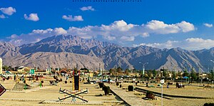
Quetta
Capital of Balochistan, Pakistan
Distance: Approx. 2699 meters
Latitude and longitude: 30.18333333,67
Quetta (; Urdu: کوئٹہ, ko'eṭa, [ˈkweːʈə] , Pashto: کوټه) is the capital and largest city of the Pakistani province of Balochistan. It is the tenth largest city in Pakistan, with an estimated population of over 1.5 million in 2024. It is situated in the south-west of the country, lying in a valley surrounded by mountains on all sides.

Quetta District
District in Balochistan, Pakistan
Distance: Approx. 871 meters
Latitude and longitude: 30.16666667,67
Quetta (Pashto: کوټه, Urdu: کوئٹہ) is a district in the northwestern part of the Balochistan province of Pakistan. According to 2023 Pakistani census population of Quetta District is 2,272,290 (2.2 million). It is part of Quetta Division.
University of Balochistan
University in Balochistan, Pakistan
Distance: Approx. 1438 meters
Latitude and longitude: 30.166,66.99
The University of Balochistan (UoB) (Urdu: جامعہ بلوچستان; Balochi: بلوچستان ء یونیورسٹی , Pashto: د بلوچستان پوهنتون ) also known as Balochistan University, is a public university located in the city center area of Quetta, Balochistan, Pakistan. UoB is the oldest highest education institution in Balochistan, having been established in 1970.

Quetta railway station
Railway station in Pakistan
Distance: Approx. 3600 meters
Latitude and longitude: 30.1915,67.0009
Quetta Railway Station (Urdu: کوئٹہ اسٹیشن, Balochi: کوئٹہ اسٹیشن) is the main railway station of Quetta, Balochistan, Pakistan and serves as a major station on the Rohri-Chaman Railway Line and the eastern terminus of the Quetta-Taftan Railway Line.
Hazara Town
Residential town in Quetta, Balochistan, Pakistan
Distance: Approx. 4360 meters
Latitude and longitude: 30.17416667,66.96083333
Hazara Town (Urdu: ہزارہ ٹاؤن, Hazaragi: آزره ټاون, Dari: شهرک هزاره) is a lower- to middle-income area on the western outskirts of Quetta, Pakistan, of which an almost all the residents are ethnic Hazaras, with a small population of Pashtuns and Baloch. Hazara Town encompasses nine blocks, beginning at Brewery Road near Bolan Medical College and continuing to Kirani road.
Mari Abad
Residential town in the city of Quetta, Balochistan, Pakistan
Distance: Approx. 3812 meters
Latitude and longitude: 30.181174,67.033081
Mariabad (Hazaragi: مری آباد) is an inner eastern suburb of Quetta, capital of Pakistan's Balochistan province. It is the most populous area of Quetta, with a population of almost half a million. Most of the population are ethnic Hazara people who belong to the Shia sect of Islam.
Hanna Valley
Valley in Balochistan, Pakistan
Distance: Approx. 3812 meters
Latitude and longitude: 30.181174,67.033081
Hanna Valley (Urdu: وادیِ ہنہ), also locally known as Shal Tungi, is a valley in Balochistan, Pakistan at a distance of 7 miles (11 kilometres) from Quetta. The people living here mostly are Kakars. Hanna Lake is located in the center of this valley.
Quetta Cantonment
Cantonment in Balochistan, Pakistan
Distance: Approx. 3812 meters
Latitude and longitude: 30.181174,67.033081
Quetta Cantonment is a military cantonment area adjacent to the city of Quetta in the Balochistan province of Pakistan.
Satellite Town, Quetta
Town in Balochistan, Pakistan
Distance: Approx. 3812 meters
Latitude and longitude: 30.181174,67.033081
Satellite Town is an upscale neighborhood and residential suburb located in the city of Quetta in Balochistan, Pakistan. The town is situated adjacent to the University of Balochistan and the headquarters of the Geological Survey of Pakistan.
2014 Quetta Airbase attack
Terrorist attack on Quetta Airport
Distance: Approx. 2699 meters
Latitude and longitude: 30.18333333,67
The 2014 Quetta airbase attack occurred on 15 August 2014, when approximately 13 Tehrik-i-Taliban militants attempted to storm two airbases of the Pakistan Army and Pakistan Air Force; PAF Base Samungli and Khalid Airbase, both located in Quetta, Balochistan, Pakistan. The attack was largely unsuccessful as Pakistani security forces foiled the attempt following a major armed engagement between the two sides which resulted in the deaths of 12 militants, while 12 people were injured, including one attacker and 11 security personnel.
Kechi Beg railway station
Railway station in Pakistan
Distance: Approx. 4405 meters
Latitude and longitude: 30.1291,66.973
Kechi Beg railway station (Urdu: کچی بیگ ریلوے اسٹیشن) is located in the Quetta District of Pakistan.

Governor's House, Quetta
Official residence of the governor of Balochistan, Pakistan
Distance: Approx. 4352 meters
Latitude and longitude: 30.1982,67.0059
Governor's House (Urdu/Balochi: گورنر ہاؤس; Pashto: ګورنر هاؤس), formerly known as the Quetta Residency, is a historical government building located on Zarghun Road in Quetta, Balochistan, Pakistan. It serves as the official residence of the governor of Balochistan. Originally built in 1888 to house the chief commissioners of Baluchistan during British rule, the building was damaged during the 1935 Quetta earthquake.
Weather in this IP's area
clear sky
14 Celsius
13 Celsius
14 Celsius
14 Celsius
1019 hPa
30 %
1019 hPa
835 hPa
10000 meters
1.32 m/s
1.36 m/s
315 degree
06:51:42
17:39:50