Country:
 Singapore
Region:
City:
Latitude and Longitude:
Time Zone:
Postal Code:
IP information under different IP Channel
ip-api
Country
Region
City
ASN
Time Zone
ISP
Blacklist
Proxy
Latitude
Longitude
Postal
Route
IPinfo
Country
Region
City
ASN
Time Zone
ISP
Blacklist
Proxy
Latitude
Longitude
Postal
Route
MaxMind
Country
Region
City
ASN
Time Zone
ISP
Blacklist
Proxy
Latitude
Longitude
Postal
Route
Luminati
Country
SGCity
singapore
ASN
Time Zone
Asia/Singapore
ISP
HUAWEI CLOUDS
Latitude
Longitude
Postal
db-ip
Country
Region
City
ASN
Time Zone
ISP
Blacklist
Proxy
Latitude
Longitude
Postal
Route
ipdata
Country
Region
City
ASN
Time Zone
ISP
Blacklist
Proxy
Latitude
Longitude
Postal
Route
Popular places and events near this IP address

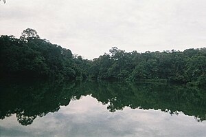
MacRitchie Reservoir
Reservoir
Distance: Approx. 1567 meters
Latitude and longitude: 1.34361111,103.83111111
MacRitchie Reservoir is Singapore's oldest reservoir. The reservoir was completed in 1868 by impounding water with an earth embankment, and was then known as the Impounding Reservoir or Thomson Reservoir.
Saint Patrick's School, Singapore
Catholic All-Boys Mission school in Marine Parade, Singapore
Distance: Approx. 10 meters
Latitude and longitude: 1.352083,103.819836
Saint Patrick's School is a government-aided Roman Catholic Lasallian all-boys' secondary school located along East Coast Road, Singapore. It is more commonly referred to as St Pat's, SPS or St Patrick's. Students and old boys call themselves Patricians or Sons of St.
Ai Tong School
Government-aided, mixed, sap school
Distance: Approx. 1730 meters
Latitude and longitude: 1.36055556,103.83277778
Ai Tong School (simplified Chinese: 爱同学校; traditional Chinese: 愛同學校; pinyin: Àitóng xuéxiào) is a primary school located in Bishan, Singapore. It is one of the five affiliated primary schools under the Singapore Hokkien Huay Kuan. As a Chinese-medium school, Ai Tong emphasises strongly on the learning of Chinese culture, language and values.
Lower Peirce Reservoir
Reservoir in Singapore
Distance: Approx. 1981 meters
Latitude and longitude: 1.36944444,103.82333333
The Lower Peirce Reservoir (Chinese: 贝雅士蓄水池下段 Malay: Takungan Air Lower Peirce) is one of the oldest reservoirs in Singapore. It is located near MacRitchie Reservoir and Upper Peirce Reservoir. Previously known as Kallang River Reservoir or Peirce Reservoir, it was renamed Lower Peirce Reservoir after the creation of Upper Peirce Reservoir.

Syonan Shrine
Distance: Approx. 789 meters
Latitude and longitude: 1.34822222,103.81380556
Syonan Jinja (昭南神社, Shōnan Jinja, lit. "Shōnan Shrine") was a Shinto shrine at MacRitchie Reservoir, Singapore. Built by the Japanese Imperial Army during the Japanese occupation of Singapore in World War II, the shrine was destroyed directly before British forces re-occupied Singapore.
Sin Ming
Place in Singapore
Distance: Approx. 1957 meters
Latitude and longitude: 1.356525,103.83679167
Sin Ming (Chinese: 新民) is a housing estate located in the subzone of Upper Thomson in the town of Bishan, Singapore. It is roughly situated between MacRitchie Nature Reserve and Bishan-Ang Mo Kio Park. It consists of both residential and industrial areas.
Marymount, Singapore
Subzone of Bishan Planning Area in Central Region, Singapore
Distance: Approx. 1904 meters
Latitude and longitude: 1.3539,103.8368
Marymount (Chinese: 玛丽蒙, Tamil: மேரிமவுண்ட்) is a residential district in Singapore. Its boundary is made up of Ang Mo Kio Avenue in Ang Mo Kio in the north, Bishan Road in the east, Braddell Road in the south and Marymount Road in the west.

Upper Thomson MRT station
Mass Rapid Transit station in Singapore
Distance: Approx. 1511 meters
Latitude and longitude: 1.3542,103.8332
Upper Thomson MRT station is an underground Mass Rapid Transit (MRT) station on the Thomson–East Coast line (TEL) in Thomson, Singapore. As the name suggests, it is located along Upper Thomson Road. The five entrances of the station serve various developments such as Soo Chow Estate, Thomson Plaza and the Church of the Holy Spirit.
Thomson Plaza
Shopping mall in Upper Thomson Road, Singapore
Distance: Approx. 1275 meters
Latitude and longitude: 1.35470833,103.83093611
Thomson Plaza, formerly unofficially called Thomson Yaohan, is a suburban shopping mall located along Upper Thomson Road, in Singapore. Opened in 1979, Thomson Plaza is best known for having a Yaohan departmental store in the 1980s and 1990s.
1969 World Cup (men's golf)
Golf tournament
Distance: Approx. 1244 meters
Latitude and longitude: 1.344,103.812
The 1969 World Cup took place 2–5 October at Singapore Island Country Club in Singapore. It was the 17th World Cup event. The tournament was a 72-hole stroke play team event with 45 teams.
Windsor Nature Park
Nature park in Singapore
Distance: Approx. 682 meters
Latitude and longitude: 1.3575,103.8225
Windsor Nature Park is a nature park in Singapore. It was opened on 22 April 2017. The park forms a green buffer zone between Central Catchment Nature Reserve and the urbanized areas of Singapore.
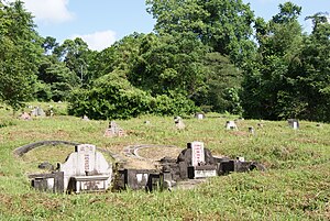
Bukit Brown Cemetery
Cemetery in Singapore
Distance: Approx. 1805 meters
Latitude and longitude: 1.3361,103.823
Bukit Brown Cemetery, also known as the Bukit Brown Municipal Cemetery or the Bukit Brown Chinese Cemetery, is a cemetery in Singapore. Originally owned by George Henry Brown, he purchased the land on hilly terrain and it became known as Brown's Hill, translated locally to Bukit Brown. After ownership for the land was passed around, it was eventually acquired by the government, who opened Bukit Brown Cemetery there in 1922.
Weather in this IP's area
broken clouds
28 Celsius
32 Celsius
27 Celsius
32 Celsius
1008 hPa
75 %
1008 hPa
1002 hPa
10000 meters
1.54 m/s
320 degree
75 %
06:58:43
19:06:27