Country:
 India
IndiaRegion:
City:
Latitude and Longitude:
Time Zone:
Postal Code:
IP information under different IP Channel
ip-api
Country
Region
City
ASN
Time Zone
ISP
Blacklist
Proxy
Latitude
Longitude
Postal
Route
IPinfo
Country
Region
City
ASN
Time Zone
ISP
Blacklist
Proxy
Latitude
Longitude
Postal
Route
MaxMind
Country
Region
City
ASN
Time Zone
ISP
Blacklist
Proxy
Latitude
Longitude
Postal
Route
Luminati
Country
INRegion
wb
City
pedong
ASN
Time Zone
Asia/Kolkata
ISP
Vodafone Idea Ltd
Latitude
Longitude
Postal
db-ip
Country
Region
City
ASN
Time Zone
ISP
Blacklist
Proxy
Latitude
Longitude
Postal
Route
ipdata
Country
Region
City
ASN
Time Zone
ISP
Blacklist
Proxy
Latitude
Longitude
Postal
Route
Popular places and events near this IP address
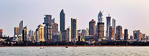
Mumbai
Capital of Maharashtra, India
Distance: Approx. 865 meters
Latitude and longitude: 19.07611111,72.8775
Mumbai ( ; Marathi: [ˈmumbəi], ISO: Muṁbaī; formerly known as Bombay) is the capital city of the Indian state of Maharashtra. Mumbai is the financial capital and the most populous city of India with an estimated population of 12.5 million (1.25 crore). Mumbai is the centre of the Mumbai Metropolitan Region, the sixth-most populous metropolitan area in the world with a population of over 23 million (2.3 crore).
Vidyavihar
Suburb in Mumbai Suburban, Maharashtra, India
Distance: Approx. 1238 meters
Latitude and longitude: 19.08,72.896
Vidyavihar is a small suburb of Mumbai. It has a railway station with the same name on the Mumbai suburban railway on the Central Railway line. The area consists of mainly the Somaiya Vidyavihar campus and a few residential buildings.

Kurla
Suburb in Mumbai Suburban, Maharashtra, India
Distance: Approx. 270 meters
Latitude and longitude: 19.07261111,72.8845
Kurla (Pronunciation: [kuɾlaː]) is a suburb of East Mumbai, India. It is the headquarters of the Kurla taluka of Mumbai Suburban district. The neighbourhood is named after the eponymous East Indian village that it grew out of.
Tilak Nagar (Mumbai)
Place in Maharashtra, India
Distance: Approx. 1099 meters
Latitude and longitude: 19.0658,72.8899
Tilak Nagar, Chembur West, Mumbai 400089. Tilak Nagar is a residential colony in Chembur of Mumbai. There is also a railway station on the Harbour Line of the Mumbai suburban railway by this name.
Don Bosco Institute of Technology, Mumbai
Distance: Approx. 784 meters
Latitude and longitude: 19.081252,72.88858
Don Bosco Institute of Technology is a private engineering college situated at Kurla (West), Mumbai affiliated with the University of Mumbai. It has been granted a "Religious Minority" status (Roman Catholics).
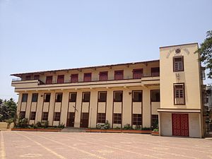
Holy Cross High School (Kurla)
Government school in Mumbai
Distance: Approx. 908 meters
Latitude and longitude: 19.08295,72.886004
Holy Cross High School is a school located in Kurla, a suburb of Mumbai, India. It prepares students for the Secondary School Leaving Certificate examinations conducted by the Maharashtra State Board of Secondary and Higher Secondary Education.

Kurla Assembly constituency
Constituency of the Maharashtra legislative assembly in India
Distance: Approx. 428 meters
Latitude and longitude: 19.073,72.882
Kurla Assembly constituency is one of the 288 Vidhan Sabha constituencies of Maharashtra state in western India. This constituency presently, after delimitation of Legislative Assembly constituencies in 2008, is reserved for the candidates belonging to the Scheduled Castes.

Tilak Nagar railway station
Railway Station in Maharashtra, India
Distance: Approx. 1099 meters
Latitude and longitude: 19.0658,72.8899
Tilak Nagar is a railway station on the Harbour Line of the Mumbai Suburban Railway network. It has two platforms which serves North and South bound railway line. The line North goes to the Chembur Railway Station while the line South goes to Kurla Railway Station.

Holy Cross Church, Kurla
Roman Catholic Church in Mumbai, India
Distance: Approx. 965 meters
Latitude and longitude: 19.08333333,72.88722222
Holy Cross Church, Kurla is a Roman Catholic Church in Kurla, a suburb of Mumbai, India. It was built during the Portuguese era by the Jesuits in 1588 and rebuilt in 1848. It is one of the oldest churches in Mumbai.
Directorate of Technical Education, Maharashtra
Distance: Approx. 842 meters
Latitude and longitude: 19.076,72.8777
The Directorate of Technical Education Maharashtra has more than 2000 educational institutions in the state use DTE Maharashtra exams. The Directorate conducts entrance test including MH-CET, the state entrance test for admission in technical institute degree courses, including Diploma courses for Bachelor of Architecture and Bachelor of Hotel Management and catering technology.
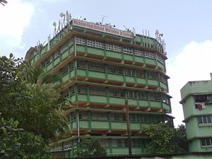
Michael High School, Kurla
Private school, catholic, co-ed school in Mumbai, Maharashtra, India
Distance: Approx. 991 meters
Latitude and longitude: 19.083485,72.883535
Michael High School is located in Kurla, a suburb of Mumbai, India. It prepares students for the Secondary School Leaving Certificate examinations conducted by the Maharashtra State Board of Secondary and Higher Secondary Education.
Parsi–Muslim riots
Riots which occurred in 1851 in Bombay
Distance: Approx. 842 meters
Latitude and longitude: 19.076,72.8777
The Parsi–Muslim riots occurred in 1851 in Bombay, and were reprised in 1874 in parts of Gujarat. These marked the beginning of a period of tension in the two communities. The first riot took place over the blurred depiction of the Islamic prophet, Muhammad, and his appearance in a public print by a Parsi newspaper, Chitra Gyan Darpan, in October 1851.
Weather in this IP's area
haze
30 Celsius
34 Celsius
30 Celsius
30 Celsius
1008 hPa
66 %
1008 hPa
1007 hPa
3000 meters
6.17 m/s
250 degree
40 %
06:24:59
18:47:36