Country:
 New Zealand
Region:
City:
Latitude and Longitude:
Time Zone:
Postal Code:
IP information under different IP Channel
ip-api
Country
Region
City
ASN
Time Zone
ISP
Blacklist
Proxy
Latitude
Longitude
Postal
Route
IPinfo
Country
Region
City
ASN
Time Zone
ISP
Blacklist
Proxy
Latitude
Longitude
Postal
Route
MaxMind
Country
Region
City
ASN
Time Zone
ISP
Blacklist
Proxy
Latitude
Longitude
Postal
Route
Luminati
Country
NZRegion
auk
City
auckland
ASN
Time Zone
Pacific/Auckland
ISP
Two Degrees Networks Limited
Latitude
Longitude
Postal
db-ip
Country
Region
City
ASN
Time Zone
ISP
Blacklist
Proxy
Latitude
Longitude
Postal
Route
ipdata
Country
Region
City
ASN
Time Zone
ISP
Blacklist
Proxy
Latitude
Longitude
Postal
Route
Popular places and events near this IP address

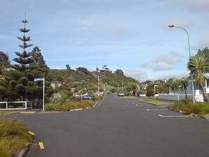
Eden Terrace
Suburb in Auckland, New Zealand
Distance: Approx. 570 meters
Latitude and longitude: -36.8671,174.7585
Eden Terrace is an inner city suburb of Auckland, located 2 km south of the Auckland CBD, in the North Island of New Zealand. Eden Terrace is one of Auckland's oldest suburbs, and also one of the smallest; at just 47 hectares only Newton is smaller. Eden Terrace is under the governance of the Auckland Council.

Newton, New Zealand
Suburb in Auckland Council, New Zealand
Distance: Approx. 300 meters
Latitude and longitude: -36.860995,174.752398
Newton (Māori: Niutana) is a small suburb of Auckland, New Zealand, under the local governance of the Auckland Council. It had a population of 1,641 in the 2013 census. Since the construction of the Central Motorway Junction in 1965–75, Newton has been divided into two parts, and as a result, lost much of its size and coherence.
Arch Hill, New Zealand
Suburb in Auckland Council, New Zealand
Distance: Approx. 630 meters
Latitude and longitude: -36.86388889,174.7475
Arch Hill is a small suburb of Auckland, New Zealand. Arch Hill is under the local governance of the Auckland Council. The area is called Arch Hill due to its "natural features".

Central Motorway Junction
Road junction in New Zealand
Distance: Approx. 578 meters
Latitude and longitude: -36.86038,174.76003
The Central Motorway Junction or CMJ (best known as Spaghetti Junction and rarely as Central Motorway Intersection), is the intersection of State Highways 1 and 16, just south of the central business district of Auckland. A multilevel structure (three traffic levels crossing in several locations), it has been described as a "fiendishly complicated, multi-layered puzzle of concrete, steel and asphalt". Carrying around 200,000 vehicles a day, it is one of the busiest stretches of road in New Zealand.

Roundhead Studios
Recording studio in New Zealand
Distance: Approx. 514 meters
Latitude and longitude: -36.86385,174.760194
Roundhead Studios is an Auckland-based sound recording studio owned by singer-songwriter Neil Finn. It was officially opened in June 2007, however by the time of its opening, several international artists had already used it whilst the studio was either in construction or receiving finishing touches. Artists who have used the facility include Australian band Augie March, US rapper Kanye West, British Indie Rock band Foals, and a range of New Zealand based artists, including Finn's son Liam Finn, Herriot Row, Eddie Rayner, Goldenhorse, Jan Hellriegel, the Topp Twins and Tim Finn.
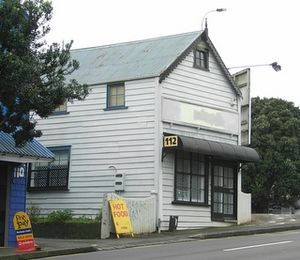
Pigeon Post House
Distance: Approx. 338 meters
Latitude and longitude: -36.8631,174.7583
The Pigeon Post House is located at 112 Newton Road, Newton, Auckland, New Zealand, on the corner of Newton Road and Upper Queen Street. From 1897 into the early 20th century the building was used as a pigeon-carrier postal service between Great Barrier Island and Auckland. It was New Zealand's first regular air-mail postal service.
1993 Auckland mid-air collision
Distance: Approx. 633 meters
Latitude and longitude: -36.8583,174.7583
The 1993 Auckland mid-air collision was an aircraft accident in New Zealand.: 2 It occurred on 26 November 1993, when two aircraft operated by Airwork, under contract to the New Zealand Police, collided and crashed in central Auckland. The mid-air collision of the Aérospatiale TwinStar helicopter and Piper Archer aeroplane resulted in the deaths of all four occupants – a civilian Airwork pilot on each aircraft and two New Zealand Police officers on the helicopter. The accident occurred in daylight with excellent visibility,: 5 in uncontrolled airspace (class G), with both aircraft flying under visual flight rules.
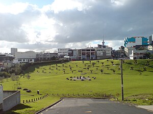
Basque Park
Distance: Approx. 307 meters
Latitude and longitude: -36.864461,174.757501
Basque Park is a north-facing reserve in Eden Terrace, a former working class suburb in central Auckland, the largest city in New Zealand. It is surrounded by Symonds Street, Newton Road, New North Road and the North Western Motorway. This green area was part of a group of important working class housing suburbs of New Zealand.
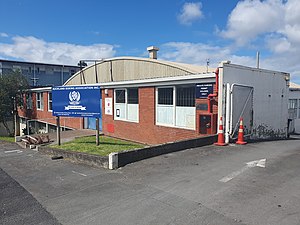
ABA Stadium
Combat sport stadium in New Zealand
Distance: Approx. 549 meters
Latitude and longitude: -36.86762,174.75697
Auckland Boxing Association Stadium (also known as ABA Stadium) is a New Zealand venue for combat sports hosting over 150 events in boxing alone. ABA Stadium is also recognized for its grassroots of boxing. The earliest reported professional boxing event according to Boxrec was in June 1992 where Jimmy Thunder fought Craig Petersen for the Australian Title.

Karanga-a-Hape railway station
Railway station in New Zealand
Distance: Approx. 626 meters
Latitude and longitude: -36.8589513,174.7592431
Karanga-a-Hape railway station is an underground railway station under construction in Auckland, New Zealand. It is scheduled to open in 2026 as part of the City Rail Link project. It will serve the Karangahape Road area with entrances on Beresford Square and Mercury Lane.

Bergman Gallery
New Zealand and Cook Islands art gallery
Distance: Approx. 388 meters
Latitude and longitude: -36.85982,174.753029
Bergman Gallery is an international commercial art gallery with an original gallery in Rarotonga, Cook Islands, and a second gallery in Auckland, New Zealand. The gallery was first established in 2016 by Ben Bergman in Rarotonga, Cook Islands. Bergman Gallery represents and has represented many significant international artists from New Zealand, Cook Islands and Australia, including Fatu Feu'u, Luise Fong, Andy Leleisi'uao, Reuben Paterson, Michel Tuffery, Billy Apple, Mahiriki Tangaroa, Sylvia Marsters, Benjamin Work, Lucas Grogan, Luke Thurgate and Telly Tuita.
Michael Lett (gallery)
Gallery in New Zealand
Distance: Approx. 625 meters
Latitude and longitude: -36.8581,174.7577
Michael Lett is a gallery dealing in contemporary art that operates in Auckland, New Zealand. The gallery was established by Michael Lett in 2003 and since 2015 he has been joined by co-director and part owner Andrew Thomas.
Weather in this IP's area
light rain
10 Celsius
9 Celsius
10 Celsius
11 Celsius
996 hPa
71 %
996 hPa
989 hPa
10000 meters
5.66 m/s
290 degree
40 %
06:18:20
18:12:58