Country:
Region:
City:
Latitude and Longitude:
Time Zone:
Postal Code:
IP information under different IP Channel
ip-api
Country
Region
City
ASN
Time Zone
ISP
Blacklist
Proxy
Latitude
Longitude
Postal
Route
Luminati
Country
ASN
Time Zone
Asia/Hong_Kong
ISP
BDX DC Services HK Limited
Latitude
Longitude
Postal
IPinfo
Country
Region
City
ASN
Time Zone
ISP
Blacklist
Proxy
Latitude
Longitude
Postal
Route
db-ip
Country
Region
City
ASN
Time Zone
ISP
Blacklist
Proxy
Latitude
Longitude
Postal
Route
ipdata
Country
Region
City
ASN
Time Zone
ISP
Blacklist
Proxy
Latitude
Longitude
Postal
Route
Popular places and events near this IP address

Quarry Bay
Area in Hong Kong
Distance: Approx. 417 meters
Latitude and longitude: 22.28313,114.21279
Quarry Bay is an area beneath Mount Parker in the Eastern District of Hong Kong Island, in Hong Kong. Quarry Bay is bordered by Sai Wan Ho to the east, Mount Parker to the south, North Point to the west, and Victoria Harbour to the north. Quarry Bay is a residential and business district in Hong Kong.

Quarry Bay station
MTR interchange station on Hong Kong Island
Distance: Approx. 271 meters
Latitude and longitude: 22.2878,114.2096
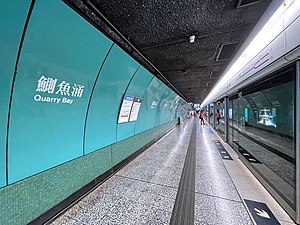
Quarry Bay (Chinese: 鰂魚涌; Cantonese Yale: Jāk'yùhchūng) is a station on the Island line and Tseung Kwan O line of the MTR in Quarry Bay on Hong Kong Island. The station livery is teal green.

Tai Koo station
MTR station on Hong Kong Island
Distance: Approx. 488 meters
Latitude and longitude: 22.2846,114.2161
Tai Koo (Chinese: 太古; pinyin: Tàigǔ; Cantonese Yale: Taaigú) is a station on the Island line of the Hong Kong MTR system. The station is located in Kornhill, Quarry Bay on Hong Kong Island and serves the area including Kornhill, Kornhill Gardens and Taikoo Shing. Tai Koo has a unique crimson livery.

Taikoo Shing
Housing estate in Quarry Bay, Hong Kong
Distance: Approx. 584 meters
Latitude and longitude: 22.286335,114.217644
Taikoo Shing or Tai Koo Shing (Cantonese pronunciation: [tʰāːi.kǔː sȅŋ]), is a private residential development in Quarry Bay, in the eastern part of Hong Kong Island, Hong Kong. It is a part of Swire's property business, along with Taikoo Place, the adjacent Cityplaza retail and office complex, and EAST, a lifestyle business hotel.

Taikoo Place
Commercial building complex in Hong Kong
Distance: Approx. 144 meters
Latitude and longitude: 22.28577778,114.21113889
Taikoo Place (Chinese: 太古坊; Jyutping: taai3 gu2 fong1; pinyin: Tàigǔfāng) is a commercial building complex located in Quarry Bay, east Hong Kong Island, Hong Kong. It comprises grade A office towers, car parking, clubs, office apartment, parks, and shops. It is reachable by MTR Island line (MTR).

Braemar Hill
Hill on Hong Kong Island, Hong Kong
Distance: Approx. 574 meters
Latitude and longitude: 22.2864177,114.2064417
Braemar Hill (Chinese: 寶馬山; Jyutping: bou2 maa5 saan1; Cantonese Yale: bóumáhsān) is a hill with a height of 200 metres (660 ft) south of Braemar Point on Hong Kong Island, Hong Kong. The hill was likely named after the Scottish village of Braemar by British officials. Contrary to popular belief, the peak of Braemar Hill lies on the eastern end of Braemar Hill Road instead of the western end, where the ascent towards Red Incense Summit is noticeably steeper.

Taikoo Dockyard
Distance: Approx. 523 meters
Latitude and longitude: 22.286,114.217
Taikoo Dockyard and Engineering Company (Chinese: 太古船塢; Jyutping: taai3 gu2 syun4 ou3) was a dockyard in what is now Taikoo Shing, MTR Tai Koo station and part of Taikoo Place of Quarry Bay on the Hong Kong Island in Hong Kong. It predates the era before the reclamation of Victoria Harbour.

One Island East
Skyscraper in Quarry Bay, Hong Kong
Distance: Approx. 163 meters
Latitude and longitude: 22.28605556,114.21336111
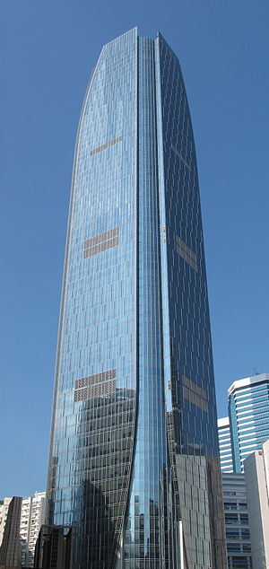
One Island East is a skyscraper in Taikoo Place, Quarry Bay, Hong Kong Island, Hong Kong.

Model Housing Estate
Housing estate in North Point, Hong Kong
Distance: Approx. 564 meters
Latitude and longitude: 22.29083,114.20868
Model Housing Estate is a public housing estate located at King's Road in Tsat Tsz Mui between Quarry Bay and North Point in Hong Kong, near MTR Quarry Bay station Exit C. It is the oldest existing public housing estate in Hong Kong. It comprises 7 residential blocks completed in 1952 to 1953, 1973 and 1979 respectively, offering a total of 667 flats.
Quarry Bay Park
Urban park in Quarry Bay, Hong Kong
Distance: Approx. 594 meters
Latitude and longitude: 22.2889,114.2173
Quarry Bay Park (Chinese: 鰂魚涌公園) is an urban park located in the Quarry Bay area of Hong Kong Island's Eastern District. It lies between the waterfront and the Tai Koo Shing housing estate, and covers around 9.79 hectares (24.2 acres). The park is managed by the Leisure and Cultural Services Department of the Hong Kong Government.
Canossa College
Catholic, all-girls' school in Hong Kong
Distance: Approx. 280 meters
Latitude and longitude: 22.2892,114.2112
Canossa College (Chinese: 嘉諾撒書院) is a Catholic, all-girls' school, founded in 1959. Canossa College is funded by the Government as a subsidised school.

Monster Building
Five buildings in Quarry Bay, Hong Kong
Distance: Approx. 291 meters
Latitude and longitude: 22.284198,114.2123
The Monster Building is a group of five connected buildings on King's Road, Quarry Bay, Hong Kong. It is a popular location for photography and has been used as inspiration for several filming locations. There are 2,243 units in five blocks with 18 floors in height.
Weather in this IP's area
broken clouds
25 Celsius
25 Celsius
23 Celsius
25 Celsius
1017 hPa
74 %
1017 hPa
1012 hPa
10000 meters
5.36 m/s
30 degree
54 %
06:37:33
17:39:24
