Country:
Region:
City:
Latitude and Longitude:
Time Zone:
Postal Code:
IP information under different IP Channel
ip-api
Country
Region
City
ASN
Time Zone
ISP
Blacklist
Proxy
Latitude
Longitude
Postal
Route
Luminati
Country
Region
jk
City
jakarta
ASN
Time Zone
Asia/Jakarta
ISP
INDO Internet, PT
Latitude
Longitude
Postal
IPinfo
Country
Region
City
ASN
Time Zone
ISP
Blacklist
Proxy
Latitude
Longitude
Postal
Route
db-ip
Country
Region
City
ASN
Time Zone
ISP
Blacklist
Proxy
Latitude
Longitude
Postal
Route
ipdata
Country
Region
City
ASN
Time Zone
ISP
Blacklist
Proxy
Latitude
Longitude
Postal
Route
Popular places and events near this IP address
International Design School
Higher education institution based in Jakarta, Indonesia
Distance: Approx. 693 meters
Latitude and longitude: -6.213898,106.834788
IDS | BTEC is a higher education institution based in Jakarta, Indonesia, with its campus at Kemang, Jakarta. IDS was founded by Andi S. Boediman in 2000, as Digital Studio College. In 2010, the school was renamed IDS | International Design School, and in February 2024 the school was renamed IDS | BTEC. IDS | BTEC, established in 2000 in Jakarta, is an educational institution specializing in visual communication encompassing design, animation, and film & media production.

Sasmita Loka Ahmad Yani Museum
Indonesian National Hero Museum in Central Jakarta, Indonesia
Distance: Approx. 370 meters
Latitude and longitude: -6.20458611,106.83656667
The Sasmita Loka Ahmad Yani Museum houses a collection from Ahmad Yani and some dioramas about the G-30-S/PKI, 30 September 1965. The museum is located in jalan Lembang 58 or jalan Laturharhari 65, Central Jakarta, Indonesia.
Philippine consulate bombing in Jakarta
2000 terror attack in Jakarta, Indonesia
Distance: Approx. 1037 meters
Latitude and longitude: -6.19972222,106.83055556
The Philippine consulate in Menteng, Jakarta, Indonesia, was bombed on 1 August 2000. A bomb was detonated outside the official residence of the Philippine ambassador to Indonesia, Leonides Caday, killing two people and injuring 21 others. Those killed were a street vendor and a guard to the official residence.
Gondangdia, Menteng
Administrative village in DKI Jakarta, Indonesia
Distance: Approx. 887 meters
Latitude and longitude: -6.2,106.83333333
Gondangdia is an administrative village in the Menteng district of Jakarta, Indonesia. It has a postal code of 10350.
Taman Suropati
Public park in Menteng, Jakarta, Indonesia
Distance: Approx. 985 meters
Latitude and longitude: -6.1993,106.8326
Taman Suropati or Suropati Park is a public park located in Menteng, Jakarta, Indonesia. The park is located in the center of Menteng and is the meeting point of three streets: Teuku Umar Street, Diponegoro Street, and Imam Bonjol Street.

Formulation of Proclamation Text Museum
History museum in Jakarta, Indonesia
Distance: Approx. 942 meters
Latitude and longitude: -6.2004,106.8311
The Formulation of Proclamation Text Museum (Indonesian: Museum Perumusan Naskah Proklamasi) is a history museum in Jakarta, Indonesia. The building is where the Proclamation of Indonesian Independence was formulated.

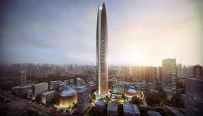
Pertamina Energy Tower
Office, observation, energy in South Jakarta, Indonesia
Distance: Approx. 1080 meters
Latitude and longitude: -6.215535,106.829652
Pertamina Energy Tower was a 99-storey, 523-metre (1,716 ft) proposed skyscraper in Jakarta, Indonesia. It was designed and planned by Skidmore, Owings & Merrill LLP (SOM), a private architecture and engineering company, and it was supposed to be the new HQ of the state-owned energy company Pertamina.

Gereja Paulus Jakarta
Protestant church in Indonesia
Distance: Approx. 911 meters
Latitude and longitude: -6.20055556,106.83138889
The GPIB Paulus Jakarta, officially known as the Gereja Protestan di Indonesian Bagian Barat "Paulus", Jakarta (English: St. Paul's Protestant Church in West Indonesia, Jakarta), is a Reformed church located in Menteng, Jakarta, Indonesia.

Rajawali Place
Hotel, Commercial offices, Residential in Jakarta, Indonesia
Distance: Approx. 760 meters
Latitude and longitude: -6.20666667,106.82861111
Rajawali Place is a prestigious 31-storey commercial office building in Setiabudi, Jakarta, Indonesia with six basement carpark spaces which form part of a mixed used superblock development comprising the luxurious ST Regis Hotel Jakarta and St Regis Residences.

Situ Lembang Park
Park in Menteng, Jakarta, Indonesia
Distance: Approx. 1042 meters
Latitude and longitude: -6.19834,106.835153
Situ Lembang Park (Indonesian: Taman Situ Lembang) is a park located at Menteng, Jakarta, Indonesia. Situ means lake, while Lembang is the name of the road adjacent the park. The park is nestled within houses of Menteng residential area and located close to another park Taman Suropati.
Embassy of the Philippines, Jakarta
Diplomatic mission of the Philippines in Indonesia
Distance: Approx. 1062 meters
Latitude and longitude: -6.19952778,106.83044444
The Embassy of the Philippines in Jakarta is the diplomatic mission of the Republic of the Philippines to the Republic of Indonesia. It is currently located at 8 Imam Bonjol Street (Indonesian: Jalan Imam Bonjol 8) in the Menteng district of Central Jakarta, near significant city landmarks like the Formulation of Proclamation Text Museum and Taman Suropati.

Setiabudi LRT Station
Distance: Approx. 600 meters
Latitude and longitude: -6.209277,106.830211
Setiabudi LRT Station is a light rail station located on Jalan H.R. Rasuna Said, Guntur, Setiabudi, South Jakarta. The station, which is located at an altitude of +22.55 meters, serves the Cibubur and Bekasi lines of the Jabodebek LRT system. Despite sharing the same name, it is not an interchange and is not to be confused with the MRT Jakarta station at Setiabudi Astra station, and is in fact located 600 meters apart from each other.
Weather in this IP's area
haze
34 Celsius
40 Celsius
33 Celsius
35 Celsius
1007 hPa
56 %
1007 hPa
1005 hPa
4000 meters
4.12 m/s
40 degree
40 %
05:25:30
17:49:15
