Country:
 Indonesia
Region:
City:
Latitude and Longitude:
Time Zone:
Postal Code:
IP information under different IP Channel
ip-api
Country
Region
City
ASN
Time Zone
ISP
Blacklist
Proxy
Latitude
Longitude
Postal
Route
IPinfo
Country
Region
City
ASN
Time Zone
ISP
Blacklist
Proxy
Latitude
Longitude
Postal
Route
MaxMind
Country
Region
City
ASN
Time Zone
ISP
Blacklist
Proxy
Latitude
Longitude
Postal
Route
Luminati
Country
IDRegion
jk
City
jakarta
ASN
Time Zone
Asia/Jakarta
ISP
BIZNET NETWORKS
Latitude
Longitude
Postal
db-ip
Country
Region
City
ASN
Time Zone
ISP
Blacklist
Proxy
Latitude
Longitude
Postal
Route
ipdata
Country
Region
City
ASN
Time Zone
ISP
Blacklist
Proxy
Latitude
Longitude
Postal
Route
Popular places and events near this IP address

Jakarta
Capital and largest city of Indonesia
Distance: Approx. 477 meters
Latitude and longitude: -6.175,106.8275
Jakarta (; Indonesian pronunciation: [dʒaˈkarta] , Betawi: Jakartè), officially the Special Capital Region of Jakarta (Indonesian: Daerah Khusus Ibukota Jakarta, abbreviated to DKI Jakarta) and formerly known as Batavia until 1949, is the capital and largest city of Indonesia. Lying on the northwest coast of Java, the world's most populous island, Jakarta is the largest metropole in Southeast Asia and serves as the diplomatic capital of ASEAN. The Special Capital Region has a status equivalent to that of a province and is bordered by two other provinces: West Java to the south and east; and (since 2000, when it was separated from West Java) Banten to the west. Its coastline faces the Java Sea to the north, and it shares a maritime border with Lampung to the west.

National Monument (Indonesia)
National monument and architectural icon of Jakarta, Indonesia
Distance: Approx. 419 meters
Latitude and longitude: -6.17538889,106.82713889
The National Monument (Indonesian: Monumen Nasional, abbreviated Monas) is a 132 m (433 ft) obelisk in the centre of Merdeka Square, Central Jakarta. It is the national monument of the Republic of Indonesia, built to commemorate the struggle for Indonesian independence. This monument is crowned with a flame covered in gold leaf which symbolizes the burning spirit of struggle of the Indonesian people.
Vice Presidential Palace (Indonesia)
Distance: Approx. 780 meters
Latitude and longitude: -6.18171,106.82963
The Vice Presidential Palace (Indonesian: Istana Wakil Presiden) is occupied by the offices of the Vice President of Indonesia, located on Merdeka Selatan Street in Jakarta. It is currently occupied by Vice President Ma'ruf Amin.
Antara (news agency)
Indonesian news agency
Distance: Approx. 390 meters
Latitude and longitude: -6.181,106.824
Antara is an Indonesian news agency organized as a statutory corporation. It is the country's national news agency, supplying news reports to many domestic media organizations. It is the only organization authorized to distribute news materials created by foreign news agencies.

Gambir, Jakarta
District in Central Jakarta, Indonesia
Distance: Approx. 299 meters
Latitude and longitude: -6.175,106.825
Gambir is a district (Indonesian: kecamatan) in the administrative city of Central Jakarta, Indonesia.. It is characterized by many historic buildings from the colonial era. It hosts some of the foremost political and learning/tourism features of the capital.

Gambir railway station
Railway station in Indonesia
Distance: Approx. 726 meters
Latitude and longitude: -6.176716,106.830508
Gambir Station (Indonesian: Stasiun Gambir, station code: GMR) is a major railway station in Gambir, Gambir, Central Jakarta, Jakarta, Indonesia. The station is located on the eastern side of Merdeka Square and the western side of the Pramuka Movement headquarters and Immanuel Church. It is operated by the KAI. During the Dutch East Indies era, the station's name was Weltevreden Station, which later changed its name to Batavia Koningsplein Station after repairs were made in the 1930s.

Bank Indonesia
Central Bank of Indonesia
Distance: Approx. 546 meters
Latitude and longitude: -6.18166667,106.82138889
Bank Indonesia (BI) is the central bank of the Republic of Indonesia. It replaced in 1953 the Bank of Java (Dutch: De Javasche Bank, DJB), which had been created in 1828 to serve the financial needs of the Dutch East Indies.

National Museum of Indonesia
Historical museum in Jakarta
Distance: Approx. 301 meters
Latitude and longitude: -6.17611111,106.82166667
The National Museum of Indonesia (Indonesian: Museum Nasional) is an archeological, historical, ethnological, and geographical museum located in Jalan Medan Merdeka Barat, Central Jakarta, right on the west side of Merdeka Square. Popularly known as the Elephant Museum (Indonesian: Museum Gajah) after the elephant statue in its forecourt, its broad collections cover all of Indonesia's territory and almost all of its history. The museum has endeavoured to preserve Indonesia's heritage for two centuries.

Merdeka Square, Jakarta
Square in Jakarta, Indonesia
Distance: Approx. 434 meters
Latitude and longitude: -6.17527778,106.82722222
Merdeka Square (Indonesian: Medan Merdeka or Lapangan Merdeka, formerly Dutch: Koningsplein, lit. "King's Square") is a large square located in the center of Jakarta, Indonesia. Merdeka is the Indonesian word for freedom or independence.
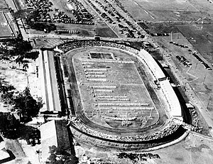
Ikada Stadium
Former multi purpose stadium in Indonesia
Distance: Approx. 434 meters
Latitude and longitude: -6.176683,106.827834
Ikada Stadium was a multi-purpose stadium in Jakarta, Indonesia, designed by Indonesian modern architect Liem Bwan Tjie.The name Ikada only appeared during the Japanese occupation as an abbreviation of Ikatan Atletik Djakarta (Jakarta Athletic Association). This field was established in colonial times by Governor-General Herman Willem Daendels (1818) and was first called Champ de Mars because it coincided with the conquest of the Netherlands by Napoleon Bonaparte. When the Dutch succeeded in reclaiming their country from France, the name was changed to Koningsplein (King's Field) but people preferred to call it Gambir Field, which is now immortalized as the name of the nearby train station.
Prince Diponegoro Monument
Historic site in Jakarta, Indonesia
Distance: Approx. 592 meters
Latitude and longitude: -6.173219,106.827167
Prince Diponegoro Monument is a bronze equestrian statue of the Javanese Prince Diponegoro boldly riding a horse. The statue is located at Merdeka Square, Jakarta, in the northern part of the park. The statue symbolizes Diponegoro's leadership of his people against the Dutch colonial rulers during the Java War of 1825-1830.

Jakarta City Hall
Seat of the Indonesian capital city government
Distance: Approx. 653 meters
Latitude and longitude: -6.1814046,106.828409
Jakarta City Hall (Indonesian: Balai Kota DKI Jakarta) is the seat of the Jakarta City government. The complex contains the official office of the governor and the vice governor of Jakarta, and the main administrative office. Jakarta City Hall is located south of Merdeka Square.
Weather in this IP's area
few clouds
33 Celsius
37 Celsius
32 Celsius
35 Celsius
1008 hPa
52 %
1008 hPa
1007 hPa
6000 meters
4.63 m/s
320 degree
20 %
05:30:04
17:45:18